
Portal:World
The World Portal


The world is the totality of entities, the whole of reality, or everything that exists. The nature of the world has been conceptualized differently in different fields. Some conceptions see the world as unique while others talk of a "plurality of worlds". Some treat the world as one simple object while others analyze the world as a complex made up of parts.
In scientific cosmology, the world or universe is commonly defined as "[t]he totality of all space and time; all that is, has been, and will be". Theories of modality talk of possible worlds as complete and consistent ways how things could have been. Phenomenology, starting from the horizon of co-given objects present in the periphery of every experience, defines the world as the biggest horizon or the "horizon of all horizons". In philosophy of mind, the world is contrasted with the mind as that which is represented by the mind. Theology conceptualizes the world in relation to God, for example, as God's creation, as identical to God or as the two being interdependent. In religions, there is a tendency to downgrade the material or sensory world in favor of a spiritual world to be sought through religious practice. A comprehensive representation of the world and our place in it, as is found in religions, is known as a worldview. Cosmogony is the field that studies the origin or creation of the world while eschatology refers to the science or doctrine of the last things or of the end of the world.
In various contexts, the term "world" takes a more restricted meaning associated, for example, with the Earth and all life on it, with humanity as a whole or with an international or intercontinental scope. In this sense, world history refers to the history of humanity as a whole and world politics is the discipline of political science studying issues that transcend nations and continents. Other examples include terms such as "world religion", "world language", "world government", "world war", "world population", "world economy", or "world championship". (Full article...)
Selected articles -
-

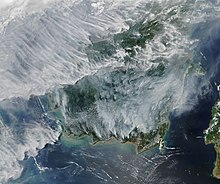
Human impact on the environment (or anthropogenic environmental impact) refers to changes to biophysical environments and to ecosystems, biodiversity, and natural resources caused directly or indirectly by humans. Modifying the environment to fit the needs of society (as in the built environment) is causing severe effects including global warming, environmental degradation (such as ocean acidification), mass extinction and biodiversity loss, ecological crisis, and ecological collapse. Some human activities that cause damage (either directly or indirectly) to the environment on a global scale include population growth, neoliberal economic policies and rapid economic growth, overconsumption, overexploitation, pollution, and deforestation. Some of the problems, including global warming and biodiversity loss, have been proposed as representing catastrophic risks to the survival of the human species.
The term anthropogenic designates an effect or object resulting from human activity. The term was first used in the technical sense by Russian geologist Alexey Pavlov, and it was first used in English by British ecologist Arthur Tansley in reference to human influences on climax plant communities. The atmospheric scientist Paul Crutzen introduced the term "Anthropocene" in the mid-1970s. The term is sometimes used in the context of pollution produced from human activity since the start of the Agricultural Revolution but also applies broadly to all major human impacts on the environment. Many of the actions taken by humans that contribute to a heated environment stem from the burning of fossil fuel from a variety of sources, such as: electricity, cars, planes, space heating, manufacturing, or the destruction of forests. (Full article...) -

The World Economic Forum (WEF) is an international advocacy non-governmental organization and think tank, based in Cologny, Canton of Geneva, Switzerland. It was founded on 24 January 1971 by German engineer Klaus Schwab.
The foundation's stated mission is "improving the state of the world by engaging business, political, academic, and other leaders of society to shape global, regional, and industry agendas". (Full article...) -
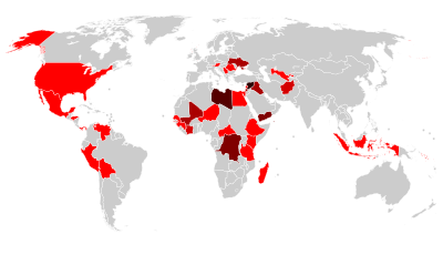
Countries with World Heritage Sites in danger. Number of sites indicated by colour: - Six or more sites
- Five sites
- Four sites
- Three sites
- Two sites
- One site
The List of World Heritage in Danger is compiled by the United Nations Educational, Scientific and Cultural Organization (UNESCO) through the World Heritage Committee according to Article 11.4 of the World Heritage Convention, which was established in 1972 to designate and manage World Heritage Sites. Entries in the list are threatened World Heritage Sites for the conservation of which major operations are required and for which "assistance has been requested". The list is intended to increase international awareness of the threats and to encourage counteractive measures. Threats to a site can be either proven imminent threats or potential dangers that could have adverse effects on a site.
In the case of natural sites, ascertained dangers include the serious decline in the population of an endangered or other valuable species or the deterioration of natural beauty or scientific value of a property caused by human activities such as logging, pollution, settlement, mining, agriculture and major public works. Ascertained dangers for cultural properties include serious deterioration of materials, structure, ornaments or architectural coherence and the loss of historical authenticity or cultural significance. Potential dangers for both cultural and natural sites include development projects, armed conflicts, insufficient management systems or changes in the legal protective status of the properties. In the case of cultural sites, gradual changes due to geology, climate or environment can also be potential dangers. (Full article...) -
The global cuisine or world cuisine is a cuisine that is practiced around the world. A cuisine is a characteristic style of cooking practices and traditions, often associated with a specific region, country or culture. To become a global cuisine, a local, regional or national cuisine must spread around the world, its food served worldwide. There have been significant improvements and advances during the 20th century in food preservation, storage, shipping and production, and today many countries, cities and regions have access to their traditional cuisines and many other global cuisines. (Full article...)
-

Artist's impression of a major asteroid impact. An asteroid caused the extinction of the non-avian dinosaurs.
A global catastrophic risk or a doomsday scenario is a hypothetical event that could damage human well-being on a global scale, even endangering or destroying modern civilization. An event that could cause human extinction or permanently and drastically curtail humanity's existence or potential is known as an "existential risk."
Over the last two decades, a number of academic and non-profit organizations have been established to research global catastrophic and existential risks, formulate potential mitigation measures and either advocate for or implement these measures. (Full article...) -
The World Factbook, also known as the CIA World Factbook, is a reference resource produced by the Central Intelligence Agency (CIA) with almanac-style information about the countries of the world. The official print version is available from the Government Publishing Office. The Factbook is available in the form of a website that is partially updated every week. It is also available for download for use off-line. It provides a two- to three-page summary of the demographics, geography, communications, government, economy, and military of 266 international entities, including U.S.-recognized countries, dependencies, and other areas in the world.
The World Factbook is prepared by the CIA for the use of U.S. government officials, and its style, format, coverage, and content are primarily designed to meet their requirements. It is also frequently used as a resource for academic research papers and news articles. As a work of the U.S. government, it is in the public domain in the United States. (Full article...) -
World history or global history as a field of historical study examines history from a global perspective. It emerged centuries ago; leading practitioners have included Voltaire (1694–1778), Hegel (1770–1831), Karl Marx (1818–1883), Oswald Spengler (1880–1936), and Arnold J. Toynbee (1889–1975). The field became much more active (in terms of university teaching, text books, scholarly journals, and academic associations) in the late 20th century.
It is not to be confused with comparative history, which, like world history, deals with the history of multiple cultures and nations, but does not do so on a global scale. World historians use a thematic approach, with two major focal points: integration (how processes of world history have drawn people of the world together) and difference (how patterns of world history reveal the diversity of the human experience). (Full article...)


General images -
-
 Standing Buddha from Gandhara, 2nd century CE
 -
 An artist's impression of the Archean, the eon after Earth's formation, featuring round stromatolites, which are early oxygen-producing forms of life from billions of years ago. After the Late Heavy Bombardment, Earth's crust had cooled, its water-rich barren surface is marked by continents and volcanoes, with the Moon still orbiting Earth half as far as it is today, appearing 2.8 times larger and producing strong tides. (from Earth)
 -
 A view of Earth with its global ocean and cloud cover, which dominate Earth's surface and hydrosphere; at Earth's polar regions, its hydrosphere forms larger areas of ice cover. (from Earth)
 -
 The pale orange dot, an artist's impression of the early Earth which might have appeared orange through its hazy methane rich prebiotic second atmosphere. Earth's atmosphere at this stage was somewhat comparable to today's atmosphere of Titan. (from History of Earth)
 -
 Cross-section through a liposome (from History of Earth)
 -
 A reconstruction of human history based on fossil data. (from History of Earth)
 -
 Graph showing range of estimated partial pressure of atmospheric oxygen through geologic time (from History of Earth)
 -
 "Lucy", the first Australopithecus afarensis skeleton found. Lucy was only 1.06 m (3 ft 6 in) tall.
 -
 Angkor Wat temple complex, Cambodia, early 12th century
 -
 A view of Earth with different layers of its atmosphere visible: the troposphere with its clouds casting shadows, a band of stratospheric blue sky at the horizon, and a line of green airglow of the lower thermosphere around an altitude of 100 km, at the edge of space (from Earth)
 -
 Ajloun Castle, Jordan
 -
 Earth's western hemisphere showing topography relative to Earth's center instead of to mean sea level, as in common topographic maps (from Earth)
 -
 Chennakesava Temple, Belur, India
 -
 Trilobites first appeared during the Cambrian period and were among the most widespread and diverse groups of Paleozoic organisms. (from History of Earth)
 -

-
 Great Mosque of Kairouan, Tunisia, founded 670 CE
 -
 Battle during 1281 Mongol invasion of Japan
 -
 Fall of the Berlin Wall, 1989
 -
 A Benin Bronze head from Nigeria
 -

-
 Artist's conception of Hadean Eon Earth, when it was much hotter and inhospitable to all forms of life. (from History of Earth)
 -
 Artist's impression of the enormous collision that probably formed the Moon (from History of Earth)
 -
 Tiktaalik, a fish with limb-like fins and a predecessor of tetrapods. Reconstruction from fossils about 375 million years old. (from History of Earth)
 -
 Great Pyramids of Giza, Egypt
 -
 Persepolis, Achaemenid Empire, 6th century BCE
 -
 Last Moon landing: Apollo 17 (1972)
 -

-
 Olmec colossal head, now at the Museo de Antropología de Xalapa
 -
 Map of peopling of the world (Southern Dispersal paradigm), in thousands of years ago.
 -
 A computer-generated image mapping the prevalence of artificial satellites and space debris around Earth in geosynchronous and low Earth orbit (from Earth)
 -
 Yggdrasil, an attempt to reconstruct the Norse world tree which connects the heavens, the world, and the underworld. (from World)
 -
 Artist's conception of Devonian flora (from History of Earth)
 -
 First airplane, the Wright Flyer, flew on 17 December 1903.
 -
 Earth's night-side upper atmosphere appearing from the bottom as bands of afterglow illuminating the troposphere in orange with silhouettes of clouds, and the stratosphere in white and blue. Next the mesosphere (pink area) extends to the orange and faintly green line of the lowest airglow, at about one hundred kilometers at the edge of space and the lower edge of the thermosphere (invisible). Continuing with green and red bands of aurorae stretching over several hundred kilometers. (from Earth)
 -
 Dinosaurs were the dominant terrestrial vertebrates throughout most of the Mesozoic (from History of Earth)
 -
 Empires of the world in 1898
 -
 A 580 million year old fossil of Spriggina floundensi, an animal from the Ediacaran period. Such life forms could have been ancestors to the many new forms that originated in the Cambrian Explosion. (from History of Earth)
 -
 Lithified stromatolites on the shores of Lake Thetis, Western Australia. Archean stromatolites are the first direct fossil traces of life on Earth. (from History of Earth)
 -
 A pillar at Göbekli Tepe
 -
 Earth's axial tilt causing different angles of seasonal illumination at different orbital positions around the Sun (from Earth)
 -
 Image of the physical world, captured by the Hubble Space Telescope (from World)
 -
 An artist's impression of ice age Earth at glacial maximum. (from History of Earth)
 -

-
 Shanghai. China urbanized rapidly in the 21st century.
 -
Artist's impression of Earth during the later Archean, the largely cooled planetary crust and water-rich barren surface, marked by volcanoes and continents, features already round microbialites. The Moon, still orbiting Earth much closer than today and still dominating Earth's sky, produced strong tides. (from History of Earth)
-
 Machu Picchu, Inca Empire, Peru
 -
 Chloroplasts in the cells of a moss (from History of Earth)
 -
 The replicator in virtually all known life is deoxyribonucleic acid. DNA is far more complex than the original replicator and its replication systems are highly elaborate. (from History of Earth)
 -
 View of Earth from the Moon by the Lunar Reconnaissance Orbiter (from Earth)
 -

-
 An animation of the changing density of productive vegetation on land (low in brown; heavy in dark green) and phytoplankton at the ocean surface (low in purple; high in yellow) (from Earth)
 -
 Earth's history with time-spans of the eons to scale (from History of Earth)
 -

-

-

-
 Notre-Dame de Paris, France
 -

-
 Tracy Caldwell Dyson, a NASA astronaut, observing Earth from the Cupola module at the International Space Station on 11 September 2010 (from Earth)
 -

-

-
 A composite image of artificial light emissions at night on a map of Earth (from Earth)
 -

-

-
 Artist's rendition of an oxinated fully-frozen Snowball Earth with no remaining liquid surface water. (from History of Earth)
 -

-
 A composite image of Earth, with its different types of surface discernible: Earth's surface dominating Ocean (blue), Africa with lush (green) to dry (brown) land and Earth's polar ice in the form of Antarctic sea ice (grey) covering the Antarctic or Southern Ocean and the Antarctic ice sheet (white) covering Antarctica. (from Earth)
 -
Pale orange dot, an artist's impression of Early Earth, featuring its tinted orange methane-rich early atmosphere (from Earth)
-
 Artist's impression of a Hadean landscape with the relatively newly formed Moon still looming closely over Earth and both bodies sustaining strong volcanism. (from History of Earth)
 -

-
 Satellite time lapse imagery of Earth's rotation showing axis tilt (from Earth)
 -
 Japanese depiction of a Portuguese carrack. European maritime innovations led to proto-globalization.
 -
 Vitruvian Man by Leonardo da Vinci epitomizes the advances in art and science seen during the Renaissance. (from History of Earth)
 -
 An artist's rendering of a protoplanetary disk (from History of Earth)
 -

-
 A map of heat flow from Earth's interior to the surface of Earth's crust, mostly along the oceanic ridges (from Earth)
 -
 Ming dynasty section, Great Wall of China
 -
 Obelisk of Axum, Ethiopia
 -
 A 2012 artistic impression of the early Solar System's protoplanetary disk from which Earth and other Solar System bodies were formed (from Earth)
 -
 A schematic view of Earth's magnetosphere with solar wind flowing from left to right (from Earth)
 -

-

-
 Earth's land use for human agriculture in 2019 (from Earth)
 -
 A reconstruction of Pannotia (550 Ma). (from History of Earth)
 -

-
 A banded iron formation from the 3.15 Ga Moodies Group, Barberton Greenstone Belt, South Africa. Red layers represent the times when oxygen was available; gray layers were formed in anoxic circumstances. (from History of Earth)
 -
 Taj Mahal, Mughal Empire, India
 -
 Geologic map of North America, color-coded by age. From most recent to oldest, age is indicated by yellow, green, blue, and red. The reds and pinks indicate rock from the Archean.
 -

-
 Florence, birthplace of the Italian Renaissance
 -
 Change in average surface air temperature and drivers for that change. Human activity has caused increased temperatures, with natural forces adding some variability. (from Earth)
 -
 Pangaea was a supercontinent that existed from about 300 to 180 Ma. The outlines of the modern continents and other landmasses are indicated on this map. (from History of Earth)
 -
 The Pantheon, originally a Roman temple, now a Catholic church
.jpeg)


.jpg)


.svg)


.jpg)


.jpg)


Megacities of the world -
.jpg)
Tehran (Persian: تهران; /tɛəˈræn, -ˈrɑːn, ˌteɪ-/; [tehˈɾɒːn] is the capital and largest city of Iran, also serving as the capital of the province, the county and the Central District. With a population of around 9.4 million in the city, and 16.8 million in the metropolitan area, Tehran is the most populous city in Iran and Western Asia, the second-largest metropolitan area in the West Asia, and the 24th most populous metropolitan area in the world. Greater Tehran includes several municipalities, including "New Town of Andisheh", "Islam Shahr", "Shahreh Qods", "Shahryar", "Pakdasht", "Firooz Kooh" and "Shamiran".
Settlement in Tehran dates back over 6,000 years, with the name was first mentioned in historical accounts in an 11 th-century chronicle as a small village in the north of ancient Ray, a prominent Median city. Ray was later absorbed into the metropolitan area of Greater Tehran. The city was first chosen as the capital of Iran by Agha Mohammad Khan of the Qajar Empire in 1786, because of its proximity to Iran's territories in the Caucasus, then separated from Iran in the Russo-Iranian Wars, to avoid the vying factions of the previously ruling Iranian dynasties. The capital has been moved several times throughout history, however, and Tehran became the nation's 32nd capital. Large-scale construction works began in the 1920s, and Tehran became a destination for mass migrations from all over Iran since the 20th century. (Full article...)Did you know -

- ... that Alexander Bannwart got into a fistfight with the pro-war senator Henry Cabot Lodge over America's proposed entry into World War I?
- ... that later pressings of the soundtrack of the soft porn film The Stud replaced Manfred Mann's Earth Band's "Davy's on the Road Again" after a journalist blabbed its presence to the band's keyboardist?
- ... that there are only about 30 Ancient Egyptian obelisks left standing worldwide—and Italy has more than Egypt?
- ... that in 1943, the United States Army conducted a large-scale battle near Stauffer, Oregon, as part of the Oregon Maneuver training exercise preparing troops for combat in World War II?
- ... that Judith Ehrlich incorporated her NPR work on pacifism into a documentary focusing on conscientious objectors during World War II?
- ... that Dr. Disaster's office collapsed in an earthquake on this day in 2011?
- ... that episodes of Angel, Lost, and The Office inspired the writer of The Flash series finale?
- ... that BBC radio broadcaster Venu Chitale taught listeners how to cook without meat when it was rationed during the Second World War?
Countries of the world -

Hong Kong is a special administrative region of the People's Republic of China. With 7.4 million residents of various nationalities in a 1,104-square-kilometre (426 sq mi) territory, Hong Kong is one of the most densely populated territories in the world.
Hong Kong was established as a colony of the British Empire after the Qing dynasty ceded Hong Kong Island in 1841–1842 as a consequence of losing the First Opium War. The colony expanded to the Kowloon Peninsula in 1860 and was further extended when the United Kingdom obtained a 99-year lease of the New Territories in 1898. Hong Kong was occupied by Japan from 1941 to 1945 during World War II. The territory was handed over from the United Kingdom to China in 1997. Hong Kong maintains separate governing and economic systems from that of mainland China under the principle of one country, two systems. (Full article...)
Related portals
Protected areas of the world -
-
Protected areas of Slovakia are areas that need protection because of their environmental, historical or cultural value to the nation. Protected areas in Slovakia are managed by institutions and organizations governed by the Ministry of the Environment.
Types of protected areas:- National Park (Slovak: Národný park; abbr. NP)
- Protected Landscape Area (Chránená krajinná oblasť; CHKO)
- National Nature Reserve (Národná prírodná rezervácia; NPR)
- Nature Reserve (Prírodná rezervácia; PR)
- National Nature Monument (Národná prírodná pamiatka; NPP)
- Nature Monument (Prírodná pamiatka; PP)
- Protected Site (Chránený areál; CHA)
- Protected Landscape Element (Chránený krajinný prvok; CHKP)
- Protected Bird Area* (Chránené vtáčie územie; CHVÚ) *Technically Special Protection Area (SPA) under the EU Bird's Directive
- Protected Tree (Chránený strom; CHS)
-
The protected areas of South Africa include national parks and marine protected areas managed by the national government, public nature reserves managed by provincial and local governments, and private nature reserves managed by private landowners. Most protected areas are intended for the conservation of flora and fauna. National parks are maintained by South African National Parks (SANParks). A number of national parks have been incorporated in transfrontier conservation areas.
Protected areas may also be protected for their value and importance as historical, cultural heritage or scientific sites. More information on these can be found in the list of heritage sites in South Africa. (Full article...) -
Protected areas of Tamil Nadu cover an area of 3,305 km2 (1,276 sq mi), constituting 2.54% of the geographic area and 15% of the 22,643 km2 (8,743 sq mi) recorded forest area of the state of Tamil Nadu in South India. It ranks 14th among all the states and union territories of India in terms of total protected area.
Protected areas in South India were created from private hunting grounds of the erstwhile Maharajas of the princely states. Mudumalai National Park was established in 1940 and was the first modern wildlife sanctuary in South India. The protected areas are administered by the Ministry of Environment and Forests of Government of India and the Tamil Nadu Forest Department. (Full article...) -

Viru bog in Lahemaa National Park
Protected areas in Estonia are national parks, nature reserves and landscape protection areas (nature parks).
Estonia has five national parks, 167 nature reserves and 152 landscape conservation areas. In addition, there are 116 (118) protected areas with an old (Soviet-era) protection regulation and 537 parks. In total, 18.1% of Estonia are protected nature areas, with Lääne County having the highest percentage (32%) and Põlva County the lowest percentage of protected areas, about 9%. (Full article...) -
Andohahela National Park in southern Madagascar
The national parks of Madagascar include all officially recognized protected areas as of 2015. The protected areas network of Madagascar is managed by the Madagascar National Parks Association (PNM-ANGAP). The network includes three types of protected areas: Strict Nature Reserves (IUCN category Ia), National Parks (IUCN category II) and Wildlife Reserves (IUCN category IV). At the 2003 IUCN World Parks Congress in Durban, the Malagasy President, Marc Ravalomanana, announced an initiative to more than triple the area under protection from approximately 17,000 km2 (6,600 sq mi) to over 60,000 km2 (23,000 sq mi) (from 3% to 10% of Madagascar's area). This "Durban Vision", as it has been dubbed, involved broadening the definition of protected areas in the country and legislation has been passed to allow the creation of four new categories of protected area: Natural Parks (IUCN category II), Natural Monuments (IUCN category III), Protected Landscapes (IUCN category V), and Natural Resource Reserves (IUCN category VI). As well as allowing these new objectives for protected areas management, the new legislation also provided for entities other than PNM-ANGAP to manage protected areas, such as government ministries, community associations, NGOs and other civil society organizations, and the private sector. (Full article...) -
The Protected areas of New South Wales include both terrestrial and marine protected areas. there are 225 national parks in New South Wales. A number established since the late 1970s followed campaigns by local residents and environmentalists.
Based on the Collaborative Australian Protected Area Database (CAPAD) 2020 data there are 2136 separate terrestrial protected areas with a total land area of 7,696,641 hectares (19,018,810 acres) (9.61% of the state's area). CAPAD data also shows 18 marine protected areas with a total area of 348,849 hectares (862,020 acres), covering 39.63% of NSW waters. (Full article...) -
This is a list of protected areas of Sierra Leone, including national parks, game reserves, conservation areas, wetlands, and those that are listed as proposed protected areas in the UN Environment Programme World Conservation Monitoring Centre (UNEP WCM) database. (Full article...)
-

There are numerous parks throughout the sovereign island country of Singapore. This is a list of parks in Singapore that are currently existing and have articles on Wikipedia. Most parks in Singapore are managed by the National Parks Board, although smaller neighbourhood parks are managed by the Housing Development Board. Most of these parks are connected via the Park Connector Network (PCN). (Full article...) -
The protected areas of Finland include national parks, nature reserves and other areas, with a purpose of conserving areas of all of Finland's ecosystems and biotopes.
Protected areas include:- National parks of Finland (Kansallispuisto/Nationalpark) - 8,170 km2
- Strict nature reserves of Finland (Luonnonpuisto/Naturreservat) - 1,530 km2
- Mire reserves of Finland (Soidensuojelualue/Myrskyddsområde) - 4,490 km2
- Protected herb-rich forest areas (Lehtojensuojelualue/Lundskyddsområde) - 13 km2
- Protected old-growth forest areas (Vanhat metsät/Gamla skogar) - 100 km2
- Grey seal protection areas (Hylkeidensuojelualue/Sälskyddsområde) - 190 km2
- Other protected areas on state-owned land - 468 km2
-
A list of protected areas of Oman:
- Al Wusta Wildlife Reserve
- Ra's Al Hadd Turtle Reserve
- Ad Dimaniyat Islands Reserve
- Al Saleel National Park (As Salil Natural Park)
- Jabal Samhan Nature Reserve
- Al Jabal Al Akhdar Scenic Reserve
- Western Hajer Stars Lights Reserve
- Arabian Oryx Sanctuary
- Al Rustaq Wildlife Reserve
- Al Wusta Wetland Reserve
- Jabal Qahwan Nature Reserve
- Al Sareen Nature Reserve
- Ras al Shajar Nature Reserve
- Al Khuwuair Nature Reserve
- Khawrs of the Salalah Coast Reserve
-
As of present, there are around 400 protected areas in Pakistan that are recognized by IUCN. The total protected land area represents 13% of Pakistan's landmass as of 2020, The Government of Pakistan plans to increase it to at least 15% by 2023. As a signatory of the UN Convention on Biological Diversity, Pakistan is committed to expanding its protected areas to encompass 17% of its total territory by the year 2030. This ambitious goal aims to ensure the long-term conservation of nature, safeguard vital ecosystem services, and preserve the cultural values associated with these protected areas. (Full article...)
-
The mountain of Stob Binnein lies in the Loch Lomond and The Trossachs National Park.
Many parts of Scotland are protected in accordance with a number of national and international designations because of their environmental, historical or cultural value. Protected areas can be divided according to the type of resource which each seeks to protect. NatureScot has various roles in the delivery of many environmental designations in Scotland, i.e. those aimed at protecting flora and fauna, scenic qualities and geological features. Historic Environment Scotland is responsible for designations that protect sites of historic and cultural importance. Some international designations, such as World Heritage Sites, can cover both categories of site.
The various designations overlap considerably with many protected areas being covered by multiple designations with different boundaries. (Full article...) -
"Temple Gate" Rock formation at Alkhanay National Park
Protected areas of Russia, (official Russian title: Russian: Особо охраняемые природные территории, literally "Specially Protected Natural Areas"), is governed by the corresponding 1995 law of the Russian Federation. (Full article...) -
-
Protected areas of Libya include any geographical area protected for a specific use.
Most protected areas are intended for the conservation of flora and fauna. Libya's national parks and nature reserves are maintained by the "Technical Committee of Wildlife and National Parks" which was created in 1990, as part of the General Secretariat of Agricultural Reclamation and Land Reform. (Full article...)


Selected world maps
-
 The Goode homolosine projection is a pseudocylindrical, equal-area, composite map projection used for world maps.
 -
 The world map by Gerardus Mercator (1569), the first map in the well-known Mercator projection
 -
 1516 map of the world by Martin Waldseemüller
 -
 A plate tectonics map with volcano locations indicated with red circles
 -
 Mollweide projection of the world
 -
 Index map from the International Map of the World (1:1,000,000 scale)
 -
 United Nations Human Development Index map by country (2016)
 -
 Time zones of the world
 -
 Only a few of the largest large igneous provinces appear (coloured dark purple) on this geological map, which depicts crustal geologic provinces as seen in seismic refraction data


World records
- List of Olympic records in athletics
- List of world records in athletics
- List of junior world records in athletics
- List of world records in masters athletics
- List of world youth bests in athletics
- List of IPC world records in athletics
- List of world records in canoeing
- List of world records in chess
- List of cycling records
- List of world records in track cycling
- List of world records in finswimming
- List of world records in juggling
- List of world records in rowing
- List of world records in speed skating
- List of world records in swimming
- List of IPC world records in swimming
- List of world records in Olympic weightlifting
Topics

Continents of Earth | ||||||||
|---|---|---|---|---|---|---|---|---|
| ||||||||
| ||||||||
| ||||||||


| Cenozoic Era (present–66.0 Ma) |
| ||||||||||||
|---|---|---|---|---|---|---|---|---|---|---|---|---|---|
| Mesozoic Era (66.0–252 Ma) |
| ||||||||||||
| Paleozoic Era (252–539 Ma) |
| ||||||||||||
| Proterozoic Eon (539 Ma–2.5 Ga) |
| ||||||||||||
| Archean Eon (2.5–4 Ga) | |||||||||||||
| Hadean Eon (4–4.6 Ga) | |||||||||||||
ka = kiloannum (thousands years ago); Ma = megaannum (millions years ago); Ga = gigaannum (billions years ago). See also: Geologic time scale • | |||||||||||||
| Locations | ||
|---|---|---|
| Related | ||

| |||||||||||||||||||
| |||||||||||||||||||
| |||||||||||||||||||

Economic classification of countries | |||||
|---|---|---|---|---|---|
| Three-World Model | |||||
| Gross domestic product (GDP) |
| ||||
| Gross national income (GNI) | |||||
| Wages | |||||
| Wealth | |||||
| Other national accounts | |||||
| Human development | |||||
| Digital divide | |||||
| Net international investment position (NIIP) | |||||
| Technological |
| ||||
|---|---|---|---|---|---|
| Sociological | |||||
| Ecological |
| ||||
| Biological |
| ||||
| Astronomical | |||||
| Eschatological |
| ||||
| Others |
| ||||
| Fictional | |||||
| Organizations | |||||
Categories

Wikimedia
The following Wikimedia Foundation sister projects provide more on this subject:
-
 Commons
Free media repository -
 Wikibooks
Free textbooks and manuals -
 Wikidata
Free knowledge base -
 Wikinews
Free-content news -
 Wikiquote
Collection of quotations -
 Wikisource
Free-content library -
 Wikispecies
Directory of species -
 Wikiversity
Free learning tools -
 Wikivoyage
Free travel guide -
 Wiktionary
Dictionary and thesaurus


