
Hauneck
This article includes a list of references, related reading, or external links, but its sources remain unclear because it lacks inline citations. (February 2024) |
Hauneck | |
|---|---|
 Coat of arms | |
Location of Hauneck within Hersfeld-Rotenburg district 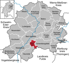 | |
 Hauneck  Hauneck | |
| Coordinates: 50°49′N 09°44′E / 50.817°N 9.733°E | |
| Country | Germany |
| State | Hesse |
| Admin. region | Kassel |
| District | Hersfeld-Rotenburg |
| Subdivisions | 7 districts |
| Government | |
| • Mayor (2022–28) | Stephan Bolender[1] (SPD) |
| Area | |
| • Total | 17.75 km2 (6.85 sq mi) |
| Elevation | 232 m (761 ft) |
| Population (2022-12-31)[2] | |
| • Total | 3,217 |
| • Density | 180/km2 (470/sq mi) |
| Time zone | UTC+01:00 (CET) |
| • Summer (DST) | UTC+02:00 (CEST) |
| Postal codes | 36282 |
| Dialling codes | 06621 |
| Vehicle registration | HEF |
| Website | www.hauneck.de |
Hauneck is a municipality in Hersfeld-Rotenburg district in eastern Hesse, Germany.
Geography[edit]
Location[edit]
The town of Bad Hersfeld lies right nearby to the north. Some 35 km away lie Fulda to the south and Alsfeld to the west.
The community stretches along the Haune. A few kilometres to the north, the Haune flows into the Fulda.

Constituent communities[edit]
The community's Ortsteile are Bodes, Eitra, Fischbach, Oberhaun, Rotensee, Sieglos and Unterhaun.
Neighbouring communities[edit]
These are Bad Hersfeld, Schenklengsfeld, Eiterfeld, Haunetal and Niederaula.

History[edit]

In 972 came the first documentary mention of a chapel. It is believed to have served as a pilgrimage place. The village developing here had its first documentary mention in 1217 in a document from the abbot of Hersfeld Abbey, Ludwig I to the Vogt (roughly “reeve”) Bertho von Buchenau, in which the place is named as Cruceberc. The chapel served over the centuries that followed as a village church. In the 16th century, the village was forsaken, until the late 17th century when another place, called Unterhaun, arose here. In 1736, the community acquired a new village church. Subsequently, the old chapel up on a bank overlooking the community fell into ruins in this century.
In the Middle Ages, the Knights of Buchenau (Buchenaouwe) held the Amt of Schildschlag and the court district of Johannesberg as a fief from the Hersfeld Abbey. To these areas belonged many of today's constituent communities. The Abbey also put the knights to work as Vögte. The Vogtei (Vogt’s seat) and the court seat lay together with the St. Johannes provost's seat at the Johannesberg. Later, under the Landgraves of Hesse, the administrative areas were ruled from Hauneck Castle (now in ruins), out of which then came the community's name in 1971.
Amalgamations[edit]

Through municipal reform on 31 December 1971, the community of Hauneck came into being with the amalgamation of Oberhaun, Rotensee, Sieglos and Unterhaun. In 1972, the formerly self-administering communities of Bodes, Fischbach and Eitra also joined the community.
Population development[edit]
| Year | 1830 | 1939 | 1970 | 1987 | 2001 |
| Inhabitants | 1,249 | 2,127 | 2,990 | 3,593 | 3,729 |
Politics[edit]
Community council[edit]
This section needs to be updated. (July 2021) |
The municipal election held on 26 March 2006 yielded the following results:
| Parties and voter communities | % 2006 |
Seats 2006 |
% 2001 |
Seats 2001 | |
| CDU | Christian Democratic Union of Germany | 12.4 | 3 | 15.3 | 3 |
| SPD | Social Democratic Party of Germany | 55.0 | 13 | 63.9 | 15 |
| FWG | Freie Wählergemeinschaft | 32.7 | 7 | 20.8 | 5 |
| Total | 100.0 | 23 | 100.0 | 23 | |
| Voter turnout in % | 57.5 | 60.3 | |||
The community's executive (Gemeindevorstand) is made up of six members, with four seats allotted to the SPD, one to the CDU and 1 to the FWG.
Mayor[edit]
The mayor Stephan Bolender (SPD) was elected on 16 January 2022 with 74% of the vote.
Coat of arms[edit]
The community's arms might be described thus: Argent a bend wavy azure between seven mullets of six gules.
The wavy bend (diagonal stripe) stands for the Haune, which flows through the community. The mullets of six (six-pointed stars) symbolize the community's seven constituent communities.
Economy and infrastructure[edit]
Transport[edit]
Hauneck lies right on Autobahn/highway/Autoroute 4, right near interchange 32 (Bad Hersfeld). Bundesstraße 27 runs along the Haune through the community. The Bebra–Fulda railway runs through Hauneck.
Culture and sightseeing[edit]

Buildings[edit]
- Church in Oberhaun from the 14th century
- Old graveyard in Unterhaun with chapel ruins (from 972) on the Crucaberc (Kirchberg)
References[edit]
- ^ "Ergebnisse der letzten Direktwahl aller hessischen Landkreise und Gemeinden" (XLS) (in German). Hessisches Statistisches Landesamt. 5 September 2022.
- ^ "Bevölkerung in Hessen am 31.12.2022 nach Gemeinden" (XLS) (in German). Hessisches Statistisches Landesamt. June 2023.
External links[edit]
- Community’s official webpage (in German)
- Hauneck at Curlie (in German)
Towns and municipalities in Hersfeld-Rotenburg district | ||
|---|---|---|
 | ||
| International | |
|---|---|
| National | |