
Gasselternijveen
Gasselternijveen | |
|---|---|
Village | |
 Protestant Church | |
 Flag | |
 The village centre (dark green) and the statistical district (light green) of Gasselternijveen in the municipality of Aa en Hunze. | |
 Gasselternijveen Location in the Netherlands  Gasselternijveen Gasselternijveen (Netherlands) | |
| Coordinates: 52°59′12″N 6°50′50″E / 52.98667°N 6.84722°E | |
| Country | Netherlands |
| Province | Drenthe |
| Municipality | Aa en Hunze |
| Area | |
| • Total | 5.61 km2 (2.17 sq mi) |
| Elevation | 5 m (16 ft) |
| Population (2021)[1] | |
| • Total | 1,785 |
| • Density | 320/km2 (820/sq mi) |
| Time zone | UTC+1 (CET) |
| • Summer (DST) | UTC+2 (CEST) |
| Postal code | 9514[1] |
| Dialing code | 0599 |
Gasselternijveen is a village in the Dutch province of Drenthe. It is a part of the municipality of Aa en Hunze, and lies about 20 km east of Assen.
History[edit]
The village was first mentioned in 1739 as "Nieuw Gasselter Veen", and means "new peat colony of Gasselte.[3]
A canal was built around 1663 by Johan Struyck to excavate the peat in the area. The colony wasn't very successfully until 1819 when the Gasselternijveenschemond was dug and connected the village to Stadskanaal. By 1844, the original canal had silted and could no longer be used.[3]
Until the early 20th-century it was mainly a village of skippers and traders.[4] Gasselternijveen was home to 488 people in 1840.[5] The Dutch Reformed church was built between 1858 and 1859, and a tower was added in 1879.[4]
Between 1905 and 1947, Gasselternijveen was connected to both the Zwolle to Stadskanaal railway and a branch line to Assen. The building was torn in 1966.[6]
Gallery[edit]
-
 Avebe potato starch factory
 -
 Village clock
 -
 Windmill "De Juffer"
 -
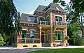 Villa Tergast


References[edit]
- ^ a b c "Kerncijfers wijken en buurten 2021". Central Bureau of Statistics. Retrieved 10 April 2022.
two entries
- ^ "Postcodetool for 9514AA". Actueel Hoogtebestand Nederland (in Dutch). Het Waterschapshuis. Retrieved 10 April 2022.
- ^ a b "Gasselternijveen - (geografische naam)". Etymologiebank (in Dutch). Retrieved 10 April 2022.
- ^ a b Ronald Stenvert (2001). Gasselternijveen (in Dutch). Zwolle: Waanders. p. 61. ISBN 90 400 9454 3. Retrieved 10 April 2022.
- ^ "Gasselternijveen". Plaatsengids (in Dutch). Retrieved 10 April 2022.
- ^ "station Gasselternijveen". Stationweb (in Dutch). Retrieved 10 April 2022.
This Drenthe location article is a stub. You can help Wikipedia by expanding it. |