
File:Plat book of Saunders County, Nebraska - containing carefully prepared township plats, village plats, analysis of U.S. land system, leading farmers directory - illustrated. LOC 2007626721-19.tif

Size of this JPG preview of this TIF file: 490 × 599 pixels. Other resolutions: 196 × 240 pixels | 393 × 480 pixels | 628 × 768 pixels | 838 × 1,024 pixels | 2,234 × 2,730 pixels.
Original file (2,234 × 2,730 pixels, file size: 17.45 MB, MIME type: image/tiff)
| This is a file from the Wikimedia Commons. Information from its description page there is shown below. Commons is a freely licensed media file repository. You can help. |
Summary
| Description |
English: Available also through the Library of Congress Web site as a raster image. Includes indexes, brief history of Saunders County, brief biographies and portraits of early Saunders County residents, and maps of Nebraska and the United States. LC copy imperfect: Wanting approx. lower 1/3 of title page, t.p. separated from binding, table of contents also partially missing. Vendor: John Carbonell (eBay auction) Acquisitions control no. 2007-047 |
||
| Title | Plat book of Saunders County, Nebraska : containing carefully prepared township plats, village plats, analysis of U.S. land system, leading farmers directory : illustrated. | ||
| Shelf ID | G1453.S35 B7 1907 | ||
| Parent | https://www.loc.gov/resource/g4193sm.gla00023/ | ||
| Sheet title | Rock Creek | ||
| Date | |||
| Source | https://www.loc.gov/item/2007626721/ | ||
| Author | Brown-Scoville Publishing Company | ||
| Permission (Reusing this file) |
|
||
| Other versions |
|
||
| Location | United States · Saunders County · Nebraska | ||
| Part of | American Memory · Catalog · County Landownership Maps · Geography And Map Division · Cultural Landscapes | ||
| Subject | Saunders County · Portraits · Directories · United States · Maps · Nebraska · Saunders County (Ne) · Real Property · Landowners · Biography · History |


Licensing
|
This is a faithful photographic reproduction of a two-dimensional, public domain work of art. The work of art itself is in the public domain for the following reason:
The official position taken by the Wikimedia Foundation is that "faithful reproductions of two-dimensional public domain works of art are public domain".
This photographic reproduction is therefore also considered to be in the public domain in the United States. In other jurisdictions, re-use of this content may be restricted; see Reuse of PD-Art photographs for details. | ||||
File history
Click on a date/time to view the file as it appeared at that time.
| Date/Time | Thumbnail | Dimensions | User | Comment | |
|---|---|---|---|---|---|
| current | 11:21, 2 July 2018 | 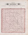 | 2,234 × 2,730 (17.45 MB) | Fæ | LOC Maps multisheet https://www.loc.gov/item/2007626721/ sheet 19 of 102 #8642 |
File usage
The following pages on the English Wikipedia use this file (pages on other projects are not listed):