
Portal:Myanmar
ကြိုဆိုပါတယ်။ / Welcome to the Myanmar Portal 

Myanmar, officially the Republic of the Union of Myanmar and also known as Burma (the official name until 1989), is a country in Southeast Asia. It is the largest country by area in Mainland Southeast Asia and has a population of about 55 million. It is bordered by Bangladesh and India to its northwest, China to its northeast, Laos and Thailand to its east and southeast, and the Andaman Sea and the Bay of Bengal to its south and southwest. The country's capital city is Naypyidaw, and its largest city is Yangon (formerly Rangoon).
Myanmar is a member of the East Asia Summit, Non-Aligned Movement, ASEAN, and BIMSTEC, but it is not a member of the Commonwealth of Nations despite once being part of the British Empire. Myanmar is a Dialogue Partner of the Shanghai Cooperation Organization. The country is very rich in natural resources, such as jade, gems, oil, natural gas, teak and other minerals, as well as also endowed with renewable energy, having the highest solar power potential compared to other countries of the Great Mekong Subregion. However, Myanmar has long suffered from instability, factional violence, corruption, poor infrastructure, as well as a long history of colonial exploitation with little regard to human development. In 2013, its GDP (nominal) stood at US$56.7 billion and its GDP (PPP) at US$221.5 billion. The income gap in Myanmar is among the widest in the world, as a large proportion of the economy is controlled by cronies of the military junta. Myanmar is one of the least developed countries; as of 2020, according to the Human Development Index, it ranks 147 out of 189 countries in terms of human development, the lowest in Southeast Asia. Since 2021, more than 600,000 people were displaced across Myanmar due to the surge in violence post-coup, with more than 3 million people in dire need of humanitarian assistance. (Full article...)
Selected articles -
-
 The military history of Myanmar (Burma) spans over a millennium, and is one of the main factors that have shaped the history of the country, and to a certain degree, the history of Southeast Asia. At various times in history, successive Burmese kingdoms were also involved in warfare against their neighbouring states in the surrounding regions of modern Burmese borders—from Bengal, Manipur and Assam in the west, to Yunnan (the southern China) in the northeast, to Laos and Siam in the east and southeast.
The Royal Burmese Army was a major Southeast Asian armed force between the 11th and 13th centuries and between 16th and 19th centuries. It was the premier military force in the 16th century when the Toungoo dynasty built the largest empire in the history of Southeast Asia. The centuries-long warfare between Burma and Siam (1547–1855) shaped not only the history of both countries but also that of mainland Southeast Asia. In the 18th and early 19th centuries, highly militaristic Konbaung kings had built the largest empire in mainland Southeast Asia until they encountered the British in present-day northeast India. Prior to the three Anglo-Burmese wars (1824–1885), previous existential threats to the country had come from China in the form of Mongol invasions (1277–1301) and Manchu invasions (1765–1769). (Full article...) -
The Padah-Lin Caves (Burmese: ဗဒလင်းဂူ, pronounced [bədəlíɰ̃ ɡù]; also Padalin or Badalin) are limestone caves located in Taunggyi District, Shan State, Burma (Myanmar). It is located near a path from Nyaunggyat to Yebock, on a spur of the Nwalabo mountains within the Panlaung Reserved Forest. There are two caves; the smaller of the two is a rock shelter while the larger cave comprises nine chambers connected by narrow passages in a north-south axis, three large sinkholes that let natural light in, and several active speleothem formations. (Full article...) -

Laphet, served in a traditional lacquer tray called laphet ok.
Burmese cuisine encompasses the diverse regional culinary traditions of Myanmar, which have developed through longstanding agricultural practices, centuries of sociopolitical and economic change, and cross-cultural contact and trade with neighboring countries at the confluence of Southeast Asia, East Asia, and South Asia, such as modern-day nations of Thailand, China, and India, respectively. Mohinga, a savory fish soup with lemongrass and banana leaves are eaten for breakfast with rice noodles, lunch is rice accompanied with small side dishes of vegetables, a small soup and a meat or fish dish. Dinner is consumed in a similar fashion to lunch. Burmese stews or curries are not Indian curries but milder with reliance on the trio of onion garlic and ginger to create savory gravies. Burmese food does not rely heavily on coconut such as in Thai cuisine. Burmese however enjoy spicy food with addition of chilis mixed into the dishes.
Burmese cuisine is typified by a wide-ranging array of dishes, including traditional stews Burmese curries, Burmese salads, accompanied by soups and a medley of vegetables that are traditionally eaten with white rice. Burmese cuisine also features Indian breads as well as noodles in many forms, such as fried, in soups, or as most popularly consumed as salads. Street food and snack culture has also nurtured the profuse variety of traditional Burmese fritters and modern savory and sweet snacks labeled under the umbrella of mont. (Full article...) -

Effect of the 2004 Indian Ocean earthquake on Myanmar
Official reports from the government of Myanmar (Burma) cite a death toll of 90 due to the tsunami caused by the 2004 Indian Ocean earthquake on 26 December 2004. However, some estimates put the toll at between 400 and 600. 30,000 citizens of Burma were estimated to be in need of shelter, food and water, and 788 buildings were reported damaged and destroyed.
An NGO estimated that 2,500 citizens of Burma based in Phang Nga Province, Thailand during the event may have been killed, and that 7,000 Burmese were still unaccounted for. Many of these missing were, however, not presumed to be dead. Many refugees fled to Thailand's interior after the destruction, or were deported or chased back into the hills that divide the countries by Thai authorities. (Full article...) -
The Burma Railway, also known as the Siam–Burma Railway, Thai–Burma Railway and similar names, or as the Death Railway, is a 415 km (258 mi) railway between Ban Pong, Thailand, and Thanbyuzayat, Burma (now called Myanmar). It was built from 1940 to 1943 by South East Asian civilians abducted and forced to work by the Japanese and a smaller group of captured Allied soldiers, to supply troops and weapons in the Burma campaign of World War II. It completed the rail link between Bangkok, Thailand, and Rangoon, Burma. The name used by the Japanese Government was Tai–Men Rensetsu Tetsudō (泰緬連接鉄道), which means Thailand-Burma-Link-Railway.
At least 250,000 Southeast Asian civilians were subjected to forced labour to ensure the construction of the Death Railway and more than 90,000 civilians died building it, as did around 12,000 Allied soldiers. The workers on the Thai side of the railway were Tamils, Malays, and fewer Chinese civilians from Malaya. Possibly over 345,000 died while working, with the death rate per month rivaling that of Auschwitz. (Full article...) -
General elections were held in Myanmar on 8 November 2015, with the National League for Democracy winning a supermajority of seats in the combined national parliament. Voting occurred in all constituencies, excluding seats appointed by the military, to select Members of Assembly to seats in both the upper house (the House of Nationalities) and the lower house (the House of Representatives) of the Assembly of the Union, and State and Region Hluttaws. Ethnic Affairs Ministers were also elected by their designated electorates on the same day, although only select ethnic minorities in particular states and regions were entitled to vote for them.
These polls were the first openly contested election held in the country since 1990, which was annulled by the military government after the National League for Democracy's (NLD) victory. The poll was preceded by the 2010 general election, which was marred by a boycott and widespread allegations of systematic fraud by the victorious Union Solidarity and Development Party (USDP). (Full article...) -
Hkakaborazi National Park is a national park in northern Myanmar with an area of 1,472 sq mi (3,810 km2). It was established in 1998.
It surrounds Hkakabo Razi, the highest mountain in the country.
It ranges in elevation from 2,950 to 18,730 ft (900 to 5,710 m) comprising evergreen forest and mixed deciduous forests in Nogmung Township, Kachin State. It is managed by the Nature and Wildlife Conservation Division.
It is contiguous with Bumhpa Bum Wildlife Sanctuary and Hukaung Valley Wildlife Sanctuary. These protected areas together with Hponkanrazi Wildlife Sanctuary comprise the largest continuous expanse of natural forest called the Northern Forest Complex stretching over an area of 11,624 sq mi (30,110 km2). Its objective is to conserve the biodiversity of the Ayeyarwady and Chindwin river basins. (Full article...) -
The Karen conflict is an armed conflict in Kayin State, Myanmar (formerly known as Karen State, Burma). It is part of the wider internal conflict in Myanmar between the military government and various minority groups. Karen nationalists have been fighting for an independent state, known as Kawthoolei, since 1949. The Karen National Union (KNU) and its Karen National Liberation Army (KNLA) are the most prominent Karen rebel groups. Hundreds of thousands of civilians have been displaced by the conflict, many of whom fled to neighbouring Thailand and survive in refugee camps.
Tensions between the Karen people and the Bamar ethnic majority in Myanmar have existed since colonial-era based on the British 'direct and indirect rule' policy and Karen soldiers' roles in putting down Burmese rebellions in the late 19th century. Around the time of Burmese independence, the Karen National Defence Organisation (KNDO) was formed as an armed wing of the Karen National Union (KNU) to put down a communist rebellion. After the Burmese government settled for peace and allowed communist back into national politics, a series of tensions, escalations and battles led to the KNU declaring formally war on the Burmese government on 31 January 1949. (Full article...) -
The Saffron Revolution (Burmese: ရွှေဝါရောင်တော်လှန်ရေး) was a series of economic and political protests and demonstrations that took place during August, September, and October 2007 in Myanmar. The protests were triggered by the decision of the national military government to remove subsidies on the sales prices of fuel. The national government is the only supplier of fuels and the removal of the price subsidy immediately caused diesel and petrol prices to increase by 66–100% and the price of compressed natural gas for buses to increase 500% in less than a week.
The various protests were led by students, political activists, including women, and Buddhist monks and took the form of a campaign of nonviolent resistance, sometimes also called civil resistance. (Full article...) -
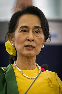
Win Myint (Burmese: ဝင်းမြင့်; MLCTS: wang: mrang. [wɪ́ɰ̃ mjɪ̰ɰ̃]; born 8 November 1951) is a Burmese politician who served as the tenth President of Myanmar from 2018 to 2021. Win Myint was removed from office in the 2021 military coup d'état. He was the Speaker of the House of Representatives of Myanmar from 2016 to 2018. He also served as a member of parliament in the House of Representatives (Pyithu Hluttaw) from 2012 to 2018. Win Myint was viewed as an important ally and of State Counsellor Aung San Suu Kyi, who served as the head of government. (Full article...)


.JPG)


.jpg)


Did you know (auto-generated) -

- ... that the Myanmar Photo Archive (example photograph shown) revealed "a side of modern Myanmar that, until very recently, remained hidden in dusty attics"?
- ... that Rangoon kept its own time for more than two decades after Burma Standard Time first came into effect?
- ... that the mission of the United Nations special envoy on Myanmar has been called a "diplomatic graveyard"?
- ... that former Burmese actress Honey Nway Oo turned rebel and took up arms against the military junta following the 2021 Myanmar coup d'état?
- ... that the Myanmar Coast Guard was initially proposed as a civilian law enforcement agency before being established as a branch of the military three years later?
- ... that Rolling Stone named Mission of Burma's "Academy Fight Song" as one of the 100 greatest debut singles of all time?
- ... that as part of the coronation of Mindon Min, the square yuzana around the capital was designated a sanctuary?
- ... that one academic described the introduction of femboys to Myanmar as a tactic to achieve an "ideological revolution"?
Related portals and projects
General images -
-
 Hlei pyaingbwè - a Burmese regatta (from Culture of Myanmar)
 -
 Portuguese ruler and soldiers mounting an Elephant. Philips, Jan Caspar (draughtsman and engraver) (from History of Myanmar)
 -
 Political Map of Burma (Myanmar) c. 1450 CE. (from History of Myanmar)
 -

-
 Mount Popa, a dormant volcano in the Central Lowlands (from Geography of Myanmar)
 -
 British soldiers remove their shoes at the entrance of Shwedagon Pagoda. To the left, a sign reads "Foot wearing is strictly prohibited" in Burmese, English, Tamil, and Urdu. (from Culture of Myanmar)
 -
 A large fracture on the Mingun Pahtodawgyi caused by the 1839 Ava earthquake. (from Geography of Myanmar)
 -
 Jade Mine in Hpakant (from Geography of Myanmar)
 -
 British soldiers on patrol in the ruins of the Burmese town of Bahe during the advance on Mandalay, January 1945. (from History of Myanmar)
 -
 Aerial view of a burned Rohingya village in Rakhine state, Myanmar, September 2017 (from History of Myanmar)
 -
 The paddle steamer Ramapoora (right) of the British India Steam Navigation Company on the Rangoon river having just arrived from Moulmein. 1895. Photographers: Watts and Skeen (from History of Myanmar)
 -
 Recorder's Court on Sule Pagoda Road, with the Sule Pagoda at the far end, Rangoon, 1868. Photographer: J. Jackson. (from History of Myanmar)
 -
 Boxing match, 19th-century watercolour (from Culture of Myanmar)
 -
 A wedding procession, with the groom and bride dressed in traditional Burmese wedding clothes, reminiscent of royal attire (from Culture of Myanmar)
 -
 A bull fight, 19th-century watercolour (from Culture of Myanmar)
 -
 Temples at Mrauk U, was the capital of the Mrauk U Kingdom, which ruled over what is now Rakhine State. (from History of Myanmar)
 -
 Pagan Kingdom during Narapatisithu's reign. Burmese chronicles also claim Kengtung and Chiang Mai. Core areas shown in darker yellow. Peripheral areas in light yellow. Pagan incorporated key ports of Lower Burma into its core administration by the 13th century. (from History of Myanmar)
 -
 A group of Buddhist worshipers at Shwedagon Pagoda, an important religious site for Burmese Buddhists (from Culture of Myanmar)
 -
 The shores of Irrawaddy River at Nyaung-U, Bagan (from Geography of Myanmar)
 -
 Two female musicians play the saung at a performance in Mandalay. (from Culture of Myanmar)
 -
 Protesters in Yangon with a banner that reads non-violence: national movement in Burmese, in the background is Shwedagon Pagoda. (from History of Myanmar)
 -

-
 A wide range of Burmese lacquerware from Bagan (from Culture of Myanmar)
 -
 Salween river at Mae Sam Laep on the Thai-Myanmar border (from Geography of Myanmar)
 -
 Protesters in Yangon carrying signs reading "Free Daw Aung San Suu Kyi" on 8 February 2021. (from History of Myanmar)
 -
 Vegetable stall on the roadside at the Madras Lancer Lines, Mandalay, January 1886. Photographer: Hooper, Willoughby Wallace (1837–1912). (from History of Myanmar)
 -
 The restored Taungoo or Nyaungyan dynasty c. 1650 CE. (from History of Myanmar)
 -
 Former US President Barack Obama poses barefoot on the grounds of Shwedagon Pagoda, one of Myanmar's major Buddhist pilgrimage sites. (from Culture of Myanmar)
 -
 Sculpture of Myanmar mythical lion (from Culture of Myanmar)
 -
 Myinhkin thabin - equestrian sport (from Culture of Myanmar)
 -
 Saint Mary's Cathedral in Downtown Yangon is the largest Roman Catholic cathedral in Burma. (from Culture of Myanmar)
 -
 19th-century funeral cart and spire, which would form part of the procession from the home to the place of cremation (from Culture of Myanmar)
 -

-
 Grandfather Island, Dawei (from Geography of Myanmar)
 -
 Myanmar (Burma) map of Köppen climate classification (from Geography of Myanmar)
 -
 A theatrical performance of the Mon dance (from Culture of Myanmar)
 -
 Aung San Suu Kyi addresses crowds at the NLD headquarters shortly after her release. (from History of Myanmar)
 -

-
 Mountains near Pindaya on the Shan Plateau (from Geography of Myanmar)
 -
 British soldiers dismantling cannons belonging to King Thibaw's forces, Third Anglo-Burmese War, Ava, 27 November 1885. Photographer: Hooper, Willoughby Wallace (1837–1912). (from History of Myanmar)


_headquarter.jpg)


Major topics
Categories

More topics

Associated Wikimedia
The following Wikimedia Foundation sister projects provide more on this subject:
-
 Commons
Free media repository -
 Wikibooks
Free textbooks and manuals -
 Wikidata
Free knowledge base -
 Wikinews
Free-content news -
 Wikiquote
Collection of quotations -
 Wikisource
Free-content library -
 Wikiversity
Free learning tools -
 Wikivoyage
Free travel guide -
 Wiktionary
Dictionary and thesaurus


