Williams Reef

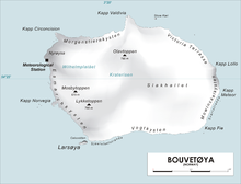
Williams Reef is a reef which extends southward for about 0.5 nautical miles (0.9 km) from Cape Fie in the island of Bouvetøya. The reef was charted in 1898 by a German expedition in the Valdivia under Carl Chun. It was recharted in December 1927 by a Norwegian expedition and named for Captain John Williams, an American sealer who had visited Bouvetoya in the schooner Golden West in 1878, making a landing on the island.[1]
References[edit]
- ^ "Prof. Dr. phil., Dr. med. h. c. Carl Chun". University of Leipzig. Retrieved October 1, 2016.
![]() This article incorporates public domain material from "Williams Reef". Geographic Names Information System. United States Geological Survey.
This article incorporates public domain material from "Williams Reef". Geographic Names Information System. United States Geological Survey.
