
Wikipedia:Graphics Lab/Map workshop/Archive/Sep 2014
| This page is an archive. Do not edit the contents of this page. Please direct any additional comments to the current main page. |

South West England

Article(s): South West England and many others
Request:
- Only nine years late... I've noticed that this map does not show the Isle of Wight (for comparison see File:EnglandSouthEast.png). It needs to be added - it's specifically mentioned at, for instance, West Country dialects. -- Ghmyrtle (talk) 18:43, 29 April 2014 (UTC)
Graphist opinion(s): Consider using locator maps from Commons:Category:SVG locator maps of regions in England (location map scheme)--TUBS (talk) 07:54, 16 May 2014 (UTC)
Literacy rate in the world
-
 Map of literacy rate in the world

Article(s): Central Europe
Request:
- This image has huge blank areas in the top and bottom areas, taking up space needlessly and forcing the actual map to be constrained to a smaller size. Please remove the blank areas. -- JIP | Talk 06:16, 2 September 2014 (UTC)
Graphist opinion(s):
Grey-land white-ocean

Article(s): Fuller projection
Request:
- Wiki-style grey-land white-ocean no cartography lines version, please... -- Kintetsubuffalo (talk) 12:47, 10 August 2014 (UTC)
Graphist opinion(s):
- I have uploaded a version modified as requested:
but it may fall foul of the bureaucracy at Commons. Maproom (talk) 20:40, 25 August 2014 (UTC)
- and has now done so. Ah well – no-one was using it anyway. Maproom (talk) 07:16, 3 September 2014 (UTC)
Megali Idea

Article(s): Megali Idea
Request:
- please change to less garish wikicolors... -- Kintetsubuffalo (talk) 15:24, 23 September 2014 (UTC)
Graphist opinion(s):
 Done Maproom (talk) 21:05, 23 September 2014 (UTC)
- Thank you!--Kintetsubuffalo (talk) 11:18, 24 September 2014 (UTC)
LTE (telecommunication)
-
 World Map of country activity Done

Article(s): LTE (telecommunication)
Request:
Graphist opinion(s):
District boundaries on Bangladesh location map
-
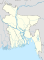 Map 1: Current location map, with first-level administrative (division) boundaries
 -
 Map 2: Example location map (Albania), with two levels of administrative boundaries


Request:
- Please add the second-level administrative (district) boundaries onto File:Bangladesh location map.svg (Map 1, above), like File:Albania location map.svg (Map 2, above), which has both first- and second-level administrative boundaries marked on the map.
- If not, please create a new map with the above requirements. Thanks. Scientific Adviser 09:38, 15 September 2014 (UTC)
Graphist opinion(s):
Local Government of Ireland

Article(s): Local government in the Republic of Ireland, NUTS of the Republic of Ireland.
Request:
- The local government boundaries of Ireland underwent some changes on 3 June 2014-
-Waterford City Council and Waterford County Council have merged.
-Limerick City Council and Limerick County Council have also merged.
-North Tipperary County Council and South Tipperary County Council have also now merged.
So would someone please change the above map to reflect that.
Graphist opinion(s):
Native American Indian Tribes - Raven Stories
-
 Tlingit tribe geography
 -
 Regional map
 -
 The Raven sits on a frog after having rescued children from a flood.

_Ethnographische_Karte,_das_Gebiet_der_TLINKIT.jpg)

Article(s): Raven Tales
Request:
- As I've been working on extensively expanding the Raven Tales article which is about they cultural stories of Indians in the north west, it's become apparent that the geography of each tribe and the relation of them to each other is significant to the stories. Reading the stories there is significant detail which describes the geography. I think it would be very interesting to compose a map which displays each of the tribes that have stories of Raven... to see the geographic comparison. Going even further it would be awesome to attempt to plot the journeys of Raven through all of the stories but this may be a very intensive endeavor to take on.
I've added extensive references to the Raven Tales article where you can get access to the original stories if you'd like to start taking a look. Thanks. I found this image [1] which should help as well. -- David Condrey (talk) 20:08, 3 September 2014 (UTC)
Graphist opinion(s):
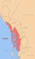
Khorloogiin Choibalsan

![[1]](http://www.bced.gov.bc.ca/abed/images/map2.jpg)
Article(s): Khorloogiin Choibalsan
Request:
- Please make added borders less draw-y, match the rest of map... -- Kintetsubuffalo (talk) 15:28, 23 September 2014 (UTC)
Graphist opinion(s):
- The borders on the rest of the map don't look draw-y because they are precise. They can be precise because they represent something real and well-defined. The borders of the territories of the proposed "Greater Mongolia" were never defined, and it would feel dishonest to draw them as precise. How would it be if someone made them greyer, or invisible, just leaving the pink patches? Unfortunately the pink patches don't quite border Mongolia, so there would be an annoying and incorrect gap. Maproom (talk) 21:48, 23 September 2014 (UTC)
- That's specious-Altai, Tuva, Buryatia and Inner Mongolia, all already labeled on the map, have well-defined borders, and do border Mongolia without any gap. It is a disservice to Wikipedia to have a map up that looks like it was sketched out in MSPaint of an afternoon. The options are improve the map or seek to have it deleted, not another halfway stopgap map that doesn't address the earlier issue.--Kintetsubuffalo (talk) 11:36, 24 September 2014 (UTC)
.svg)
Tideway
Article(s): Tideway
Request:
- The article about the tidal part of River Thames could do with a map please. -- Rob Kam (talk) 15:24, 26 September 2014 (UTC)
Graphist opinion(s):
Subterranean rivers of London
Article(s): Subterranean rivers of London
Request:
- The article about the subterranean rivers of London could do with a map please. -- Rob Kam (talk) 15:26, 26 September 2014 (UTC)
Graphist opinion(s):