
Wikipedia:Graphics Lab/Map workshop/Archive/Nov 2012
Stale[edit]
More on gray wolf range[edit]
-
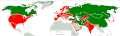 Current wolf distribution map, lacking Ethiopian range
Article(s): Gray wolf
Request: Incorporate the Ethiopian highlands (as illustrated here: http://www.ilri.org/InfoServ/Webpub/fulldocs/Bulletin17/image/FIG%201.jpg) into the species' current range (as discovered in this study http://www.ncbi.nlm.nih.gov/pmc/articles/PMC3027653/?tool=pmcentrez). Cheers. Mariomassone (talk) 19:56, 3 August 2012 (UTC)
- UPDATE: According to this study here, Gaubert P, Bloch C, Benyacoub S, Abdelhamid A, Pagani P, et al. (2012) Reviving the African Wolf Canis lupus lupaster in North and West Africa: A Mitochondrial Lineage Ranging More than 6,000 km Wide. PLoS ONE 7(8): e42740. doi:10.1371/journal.pone.0042740, Algeria, Senegal and Mali should also be incorporated. Cheers. Mariomassone (talk) 14:54, 21 August 2012 (UTC)
Graphist opinion: Not done, that isn't a gray wolf, at least as currently classified, see Egyptian Jackal. One study suggesting reclassification does not equal a consensus in the biological community. Kmusser (talk) 16:51, 24 August 2012 (UTC)
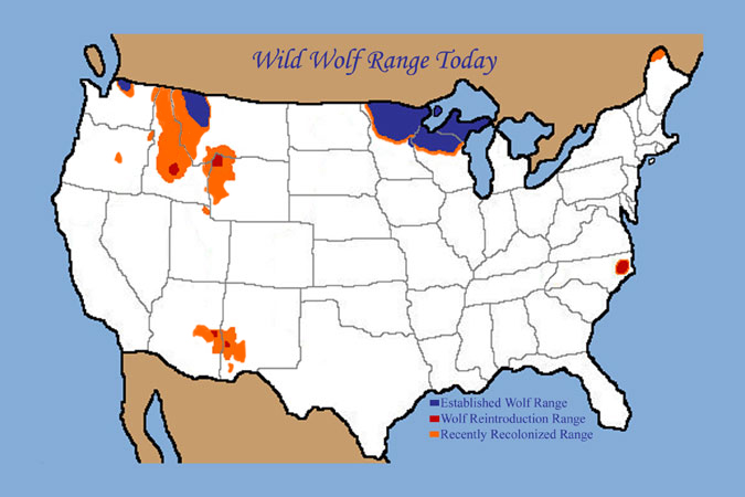
gray wolf subspecies[edit]
-
 Original disturbution
 -
 Today
Today
_subspecies-en.png)
_subspecies.gif)
Article(s): Gray wolf, Subspecies of Canis lupus
Request: We need some updates on those maps. That's a pretty easy job that won't take further than 15 minutes. First thing is the update maps of US(second map). You can find a up to date map here. Another job is, "Caspian Wolf"( purple) is now invalid, delete that subspecies and add habitat to "Eurasian Wolf"(both maps) (and delete the subspecies name at the list below). And also, "Eurasian Wolf" also found on throughout Black Sea Region(both maps). Please make that habitat. And, "Russian Wolf" is found on Central and Southern Kamchatka, add that habitat(both maps). Wolves tend to be visit Gobi Desert but that's an unusual habitat and should not be represented. Leave the Gobi Desert gray(non-habitat). That also applies to Karakum Desert(both maps). Wolves did not expirated from central Russia, fill that blank according to original distirbution map(second map). Finally, there are Tundra wolves on Northern Scandinavia(first map), make that habitat. Westnest message 11:53, 10 August 2012 (UTC)
Graphist opinion(s): OK, I updated them to make them a little more consistent with each other and the more general gray wolf map above so it should be better than it was. I think they're still pretty messed up though, the most obvious error being that the Steppe wolf and Tibetan wolf are missing entirely. For your other changes I'd want citations - really to fix this map properly we'd have citations for each subspecies range. I did a little bit of online searching but most of what I found was too vague to be useful. I did notice though that these maps don't bear much resemblance to other wolf subspecies maps out there. Kmusser (talk) 18:50, 24 August 2012 (UTC)
Baltimore / Enterprise Zone[edit]
Article(s): Baltimore Development Corporation, Urban Enterprise Zone, Baltimore
Request: It would be great to have the map of Baltimore Enterprise Zones up on this page. We did have a map, presented as fair use, but it was deleted. The user who deleted it told me that you all could help me to reconstruct the map. Well, looking around, I see there's not even an SVG map of Baltimore on Commons, so perhaps that's really the starting point. I'd like to help as much as possible, but I am pretty n00b at digital map-making. Thanks! groupuscule (talk) 02:30, 20 August 2012 (UTC)
Graphist opinion(s):
Francophonie map suspended members[edit]

Article(s): La Francophonie
Request: Please update to show that Mali and Guinea-Bissau are suspended. Liam987(talk) 12:34, 31 August 2012 (UTC)
Graphist opinion(s):
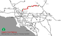
Please update the Syrian Civil War rebel-controlled zone map.[edit]
-
Free Syrian Army control zones, as of June 2012
Article(s): Syrian Civil War
Request: This map has not been updated since June. Surely the zones have changed. Please update. Thank you. 70.179.167.78 (talk) 10:33, 7 September 2012 (UTC)
Graphist opinion(s):
Operation Head Start[edit]
Article(s): Operation Head Start
Request: I was wondering if someone could turn the image here (also at 1:21 in the film) into a map. I would attempt to do it, but since I have no faith in my mapping skills, I was wondering if someone could do it for me. If you want me to upload an image of that map to Commons, I can do that. Thanks! Kevin Rutherford (talk) 05:26, 12 September 2012 (UTC)
Graphist opinion(s):
Coyote attacks on humans
-
 Most coyote attacks in the article will probably fit on this map

Article(s): Coyote attacks on humans
Request: Create a map of southern California coyote attacks to improve the article Coyote attacks on humans. Chrisrus (talk) 16:35, 12 September 2012 (UTC)
Graphist opinion(s):
Add a scale to a map[edit]
-
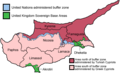 Map of Cyprus

Article(s): Tons of pages
Request: Please add a scale (both km and miles) to this map. 2001:18E8:2:1020:9A4:966F:1021:7F4A (talk) 13:22, 14 September 2012 (UTC)
Graphist opinion(s):
Iwokrama Forest[edit]
Article: Iwokrama Forest
Request: A map of the Iwokrama Forest, which lies between 4° and 5° north latitude and 58.5 and 59.5 degrees west longitude in Guyana. Here is a source for a map:
- http://antiquity.ac.uk/projgall/plew/images/figure1.jpg shows the reserve in yellow and green.--DThomsen8 (talk) 01:49, 18 September 2012 (UTC)
Sudan world map[edit]


.png)

Article(s):
Request: Draw in the border between Sudan and South Sudan on all these maps. Plus redraw all the PNG maps as SVG.
Graphist opinion(s):
Galicia[edit]
Article(s): File:Localizacion de Galicia.svg
Request: Create a new file by drawing in the borders of the Portuguese regions and colouring Galicia in the same colour as the rest of Spain.
Graphist opinion(s):
South Sudan Independence[edit]

Article(s): Decolonization of Africa
Request: Update it by having South Sudan appear last in the photoshot, as it gained independence from Sudan in 2011.
Graphist opinion(s):
Geo-referenced map of Yukon[edit]
-
 An existing location map for Yukon. Not georeferenced.
 -
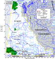 Another map that would be useful. Not georeferenced.
 -


Article(s): Ibex Valley, Category:Yukon
Request: Would it be possible to georeference these maps? Ultimately, a relief map would also be useful, but I couldn't find one in commons. If these are simple tasks, you can direct me to some help page or tutorial on my name page and I can do it myself. Keep in mind that I am not a cartographer, nor do I have any fancy software. Google earth is about as far as my mapping skills go. I'm not super happy with either of these maps, to tell you the truth, I'd like one that shows Whitehorse and the communities and the major roads in the Territory. If I can find one of those, can it be georeferenced? If neither of these maps are able to be georeferenced, please let me know. I'm willing to do some legwork as required, I just really don't know what you need. Thanks. --JonGDixon (talk)
Graphist opinion(s):
Commonwealth Realms and Republics[edit]

Article(s): Commonwealth of Nations
Request: Create a new SVG map by colouring all 16 of the Commonwealth realms in blue and the 5 other Commonwealth countries that have their own monarchies in green, and leave the 33 republics as they are, in pink.
Graphist opinion(s):
Resolved[edit]
U.S. map (with Maryland highlighted)[edit]

Article(s): Montgomery County, Maryland
Request: The Eastern Shore of Virginia is highlighted as being part of Maryland. This is incorrect. Please mark the Eastern Shore as being part of Virginia. Illegitimate Barrister (talk) 23:46, 15 October 2012 (UTC)
Graphist opinion(s): Done. Kmusser (talk) 13:47, 1 November 2012 (UTC)
Visa-exempt countries and territories to Canada[edit]
-
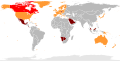 Countries and territories whose citizens are visa-exempt to Canada

Article(s): Visa policy of Canada
Request: I would be very grateful if you could make the following changes please:
- Change 5 countries (Botswana, Namibia, Saint Lucia, Saint Vincent and the Grenadines and Swaziland) from #FF9933 to #800000
- Change 3 countries (Costa Rica, Malaysia and Saudi Arabia) from #C0C0C0 to #800000
Thank you very much!
Bonus bon (talk) 08:19, 16 September 2012 (UTC)
Graphist opinion(s):
![]() Done: It wasn't exactly clear which of the Caribbean spots were supposed to be St. Lucia and St. Vincent and the Grenadines, but I changed two that were in the approximate location. Lesgles (talk) 23:10, 9 October 2012 (UTC)
Done: It wasn't exactly clear which of the Caribbean spots were supposed to be St. Lucia and St. Vincent and the Grenadines, but I changed two that were in the approximate location. Lesgles (talk) 23:10, 9 October 2012 (UTC)
Caspian dialects[edit]
-

-
 SVG map


.gif)
Article(s): Caspian languages
Request: png or svgify... Kintetsubuffalo (talk) 10:16, 15 November 2012 (UTC)
Graphist opinion(s): ![]() Request taken by ArnoldPlaton (talk).
Request taken by ArnoldPlaton (talk).
 Done. Vectorized. I added only the larger cities, as the old one was to cluttered with names. I took the liberty of adding the Semnani languages as well, due to similarity and small area of distribution (but added a note saying they are not Caspian, just a bit similar). If you feel it needs to be enlarged, somebody else should do it as I don't know how to do it. Feel free to use in articles. PS. I could add the Talysh language as well if necessary - ArnoldPlaton (talk) 22:27, 20 November 2012 (UTC)
- Fantastic, thank you!--Kintetsubuffalo (talk) 11:47, 24 November 2012 (UTC)