
Vaux-Marquenneville
Vaux-Marquenneville | |
|---|---|
 South face of the church, with the town hall behind | |
 Coat of arms | |
Location of Vaux-Marquenneville  | |
 Vaux-Marquenneville  Vaux-Marquenneville | |
| Coordinates: 49°59′08″N 1°47′10″E / 49.9856°N 1.7861°E | |
| Country | France |
| Region | Hauts-de-France |
| Department | Somme |
| Arrondissement | Abbeville |
| Canton | Gamaches |
| Intercommunality | CA Baie de Somme |
| Government | |
| • Mayor (2020–2026) | Jean-François Langlet[1] |
| Area 1 | 3.97 km2 (1.53 sq mi) |
| Population (2021)[2] | 81 |
| • Density | 20/km2 (53/sq mi) |
| Time zone | UTC+01:00 (CET) |
| • Summer (DST) | UTC+02:00 (CEST) |
| INSEE/Postal code | 80783 /80140 |
| Elevation | 70–122 m (230–400 ft) (avg. 152 m or 499 ft) |
| 1 French Land Register data, which excludes lakes, ponds, glaciers > 1 km2 (0.386 sq mi or 247 acres) and river estuaries. | |
Vaux-Marquenneville (French pronunciation: [vo maʁkɛnvil]; Picard: Veux-Martchéneville) is a commune in the Somme department in Hauts-de-France in northern France.
Geography[edit]
The commune is situated 8 miles (13 km) south of Abbeville, on the D93 road. The name Vaux derives from "vale" or "valley" and Marquenneville comes from the domain of someone called Marca.[3] The inhabitants are known as Vallois in French.
Population[edit]
|
| |||||||||||||||||||||||||||||||||||||||||||||||||||
| Source: EHESS[4] and INSEE (1968-2017)[5] | ||||||||||||||||||||||||||||||||||||||||||||||||||||
History[edit]
Known by many variants of the current name throughout the centuries: 1166: Vaux, 1557 Vaulx, 1757 Vaux 1284 Marquienvilla, 1301 Marchaigneville, 1312 Markaigneville, 1340 Markainneville, 1388 Marquenneville [6]
The Knights Templar were established nearby at Oisemont and had a farm at Vaux[7]
The first known seigneurs were the Riencourt family [7]
In 1790 the commune came under the management of the department of the Somme and in 1793 the town of Vaux (after 1801: Vaux-Marquenneville) was integrated into the arrondissement of Abbeville and the canton of Saint-Maxent, and after 1801 the canton of Hallencourt.[4]
The town was occupied, as were many French towns and villages, by the German army during World War II. In 1943 work began to build a V1 missile launch ramp at "Le Mont" in Marquenneville.
A German army deserter hid in a hangar under a pile of wheat and after fruitless search by the Wehrmacht, the soldier, with the help of the French Resistance escaped from France to Spain and return to his own home.
In June 1944. the V1 ramps were destroyed by No. 485 Squadron RNZAF. The bombardment lasted one and a half hours (from 15h45 to 17h15).
The village was liberated by a Canadian tank regiment in 1944.
Vaux-Marquenneville received the Croix de Guerre with Bronze Star from the Secretary of State for War who said: "This courageous village, badly damaged during the Second World War, was delivered by faith and hard work".
Places of interest[edit]
- The sixteenth century church.[8] The Riencourt family tomb is inside[7]
- The war memorial[9] is on the left of the entrance to the church graveyard.
-
 Church of Vaux-Marquenneville
 -
 The war memorial
 -
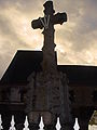
 A cross
-France).JPG)
_(Somme(80)-France).JPG)
-France)..JPG)
- The manor with a 17th-century dovecote.
- Another dovecote of the same period can be found at another farm in the village.[7]
- The school and mairie[10]
- 1834: The presbytery serves as a school and communal housing. The annual salary of the teacher was 200 francs.
- 1838-1855: Renovation of the school.
- 1861: Separation of boys and girls by a partition.
- 1873: Collapse of the west side and part of the roof.
- 1876: Introduction of the municipal library in the school.
- 1883: Establishment of the Fund Schools.
- 1889-1890: Construction of the new mixed school (now the mairie).
- Since the 1960s, the school has been closed but the building is still used as the mairie.
See also[edit]
References[edit]
- ^ "Répertoire national des élus: les maires" (in French). data.gouv.fr, Plateforme ouverte des données publiques françaises. 13 September 2022.
- ^ "Populations légales 2021". The National Institute of Statistics and Economic Studies. 28 December 2023.
- ^ Source: "Les lieudits" de la Section Patrimoine CIS N°9
- ^ a b Des villages de Cassini aux communes d'aujourd'hui: Commune data sheet Vaux-Marquenneville, EHESS (in French).
- ^ Population en historique depuis 1968, INSEE
- ^ Source: C.I.S.Section Patrimoine N°9
- ^ a b c d Source: " la Somme, les 783 communes", septembre 2004, aux éditions Delattre, Grandvilliers (60)
- ^ Histoire de Cloches [1]
- ^ "Vaux - Marquenville". Mémorial morts pour la France (80) (in French). Archived from the original on 19 November 2004.
- ^ Source: Section Patrimoine C.I.S. N°11 Pg:garde, 19, 29, 32, 52, 56
| Authority control databases: National |
|---|