
User:Steverelei
The Canadian: Scenic Highlights and other Points of Interest[edit]
 |
 |

|
The Canadian sits at the Jasper, Alberta, station amid the scenic mountains of Jasper National Park. The dome car allows passengers to enjoy views of the mountains as the train passes through Jasper National Park. The route of the Canadian across Canada.
| The Canadian | |
|---|---|
|
The Canadian:Scenic Highlights[edit]
Operating Railroad[edit]
Host Railroads[edit]
Burlington Northern Santa Fe Canadian National Canadian Pacific
Country:[edit]
Provinces through which the Canadian passes:[edit]
Cities and Major Stops
|
|
|
|
|
|
|
|
|
|
|
|
|
|
|
|
|
|
|
}}
Introduction[edit]
The Canadian is VIA Rail Canada's (VIA), premier passenger train. Westbound the train is #1, traveling across Canada from Toronto, Ontario, to Vancouver, British Columbia. Eastbound it is train #2 (Vancouver-Toronto). At 2,775 miles, it is the second longest train ride in the world. Only the Trans-Siberian Express on the Trans-Siberian Railway is longer. Since 1990, the Canadian has operated mostly over the more northerly Canadian National Railway (CN)--a route once used by its own Super Continental -- line through the Canadian Rockies instead of its more southerly Canadian Pacific (CP) route. True, it is not the same, but taken on its own merits, the "new" route over the CN still has much to offer, especially its passage through Jasper National Park with its gorgeous, spectacular mountainous scenery. Despite the route and other changes, the Canadian continues the legacy of its predecssors by continuing to provide transcontinental train service across Canada, showcasing various places, landscapes, people, and other aspects of Canadian life.
The Train[edit]
In 1955 when the original streamlined Canadian was inaugerated, the train was intended to emulate the famous California Zephyr (Chicago-Oakland) that had already been in service since 1949 with its streamlined cars including dome cars. For many people, the present-day Canadian still evokes the memories of that famous train. During the summer months, the train has an average of 20 cars (excluding locomotives) in tow, due to heavy patronage. The train is pulled by two, sometimes three GPA-30H (VIA's/Canada's version of the FP40-2) locomotives. They are rated at 3,000 HP each and presently sport VIA's handsome two-toned green Renaissance paint scheme. The locomotives have "Head End Power" (HEP) to produce the electricity for the train's lights, heating, air-conditioning, etc.
- There is also baggage car--which carries the passengers' luggage, skis, bikes, etc.
- Two coaches (chair cars).
Dome Car Gallery[edit]
Here are some scenes from the dome car, demonstrating its advantages for sightseeing. Click the individual pictures to get more information about the scenes in them.
-
 Dome cars were designed to allow passengers to enjoy panoramic views of the surrounding scenery
 -
 As seen from the dome car of the Canadian, a lake surrounded by fall colors and the prairies west of Edmonton, Alberta.
 -
 Approaching the Canadian Rocky Mountains of Jasper National Park, Alberta, as seen from the dome car.
 -
 A mountain crag as scene from the dome car of the Canadian while passing through Jasper National Park.
 -
 A dome observation car at the rear end of a VIA Rail passenger train.


- Dome car--"Skyline" series --a car with a sort of glass top bubble in which passengers can sit and enjoy panoramic views of the passing scenery. The lower level of the car has tables for playing games, eating snacks, and other activities. An attendant sells snacks, beverages, light meals, and souvenirs. The are usually four domes on the train (during summer months). One of these domes is a dome observation car--"Park "series--at the rear of the train. This is perhaps the Canadian's signature car--almost its trademark, as it can be seen in many photographs, publicity shots, and other forms of advertising. Besides the dome, the car is rounded like a bullet (hence the "Bullet Lounge")at the rear end where passengers can sit and look out the rear windows and watch the scenery receding behind the train. The car also has a "Mural Lounge," directly underneath the dome section, and one double bedroom and one triple bedroom. One dome car is open to coach passengers, while the other three (including the dome observation) are for sleeping car passengeers only. * Panorama car--also for sleeping car passengers only--is a single level coach car with wrap-around windows for extra-wide viewing. These cars only travel between Edmonton (Alberta) and Vancouver (BC)--through the most spectacular scenery.
- The Dining car is for more formal sit-down meals, serving breakfast, lunch, and dinner. Breakfast entrees include omelettes, pancakes, waffles, and other offerings. In 2011, the entrees were each priced at $12 and included fruit juice and coffee or other nonalcoholic beverages. Lunch entrees--such as caesar salad also sold for $12 with nonalcoholic beverages included. Soups, salads, desserts, and alcoholic beverages are available for extra charges. Dinner entrees were priced from $15 to $18 with the same extras for extra charges as with lunch. One diner toward the front of the train is open to coach passengers, while a second one( about midway between the sleepers) is open only to sleeping car passengers. The cost of dining car meals is included in sleeping car fares. However, alcoholic beverages are extra.
- Sleeping cars. On a 20-car train, that leaves 10 of them in various configurations. This is one of the few trains that still offers sections: seats during the day, with berths that fold down at night with curtains for privacy, like one might see in old movies. There are also private compartments such as roomettes (for one person), bedrooms (for two), suites, and other arrangements. Traditionally, certain series cars, such as the Manor or Chateau, had certain configurations, but that has changed over the years. For example since 2010, VIA undertook a $22 million renovation of some of its sleeping and dome observation cars. This has resulted in doing away with some of the smaller (sleeping) compartments and in place creating larger ones for more upscale clients--and of course charging more upscale fares. It seems to be working in that sleeping car accomodations are often all sold out during busy summer months. The train has long been popular with Japanese tourists.
During the winter, off-season months, the train is usually trimmed down to nine or ten cars: baggage, one coach, one dome, one diner, three or four sleepers, and the rear end dome observation car. It should be noted that train consists can change anytime on any trip. This article should serve as a basic guide as to what cars and services the train(s) may have.
Vancouver to Kamloops[edit]
Departing and Arriving the Vancouver Pacific Central Station[edit]


At 20 cars, the train is too long for the passenger loading platforms at the station. The train is in two parts. The front part of the train--the locomotives and first four or so cars--is on one track to the left. The other part of the train (the diners and sleepers, etc) is to the right. After the passengers have boarded the train, about 20 minutes before departure time, the front of the train moves out and backs up to hook up to the rest of the train. Then at the appointed hour--20 30 (8:30 pm), the train (as one) sets out on its transcontinental journey. Arriving at the station, the train backs into the station on the right track, unhooks the front part of the train (locomotives and first few cars), pulls forward and then backs onto the left hand track, after which coach passengers may deboard.
Leaving the station, the Canadian heads out on tracks owned by the Burlington Northern Santa Fe (BNSF) Railway, which are also used by CN freights and Amtrak passenger trains (to Seattle), passing through such other towns as Burnaby and New Westminster. Near New Westminster, the train crosses the Fraser River over the New Westminster Bridge, which is also known as the Fraser River Swing Bridge. It has a swing span to allow river traffic to pass through and closes to allow train traffic to cross. The Canadian crosses to the south bank of the river and then heads eastward (to the left); BNSF freight and Amtrak passenger trains go west (to the right).
Directional Running through the Fraser River Canyon[edit]
The two railroads--CN and CP--now have an agreement to allow directional running through the canyon as far as Basque. All eastbound trains--CN, CP, and VIA Rail's eastbound Canadian--run on the CP line. All westbound trains--CN, CP, VIA Rail's westbound Canadian--use the CN tracks. Before the canyon, at Gifford, the train diverts from the CN line, crosses a bridge over the Fraser River to Mission (back over to the north side of the river) where it joins with the CP for the eastbound trip through the canyon. This puts the Canadian back on its home CP rails for much of the route through the canyon. True, it is during the middle of the night when most passengers are asleep, but savy, night-owls can do some sightseeing through a very scenic area.The Fraser River Canyon begins about 90 miles east of Vancouver. Although timetable list trains as east/westbound, they are actually traveling conpass north/south in direction. The Fraser River and the Thompson River canyons are known as "Avalanche Alley," and for good reason. The railroads are often perched precariously along canyon walls overlooking an often tumultuous river; both railroads have built numerous tunnels, bridges, snow and rock sheds, and miles of slide detector fences to protect their lines. The journey for the train traveler is certainly adventurous but is relatively smooth. Passenger trains are allowed a maximum speed of 40 mph through the canyon, though there are times and places where it feels as though the train may be going a bit faster. Also from the train, one can often see other trains headed west on the CN line on the opposite side of the river.
.jpg)
Cisco Bridges[edit]
At Siska, a few minutes south of Lytton, there are the Cisco bridges--a pair of railway bridges at the throat of a rocky gorge. From south to north, the CP has been on the west side of the canyon, while the CN has been on the east side. Here, two railroads switch sides: the CP--(520 ft)-long truss bridge; the eastbound Canadian uses this bridge--crosses to the east, the CN--on a 810-ft steel-arched bridge over the CP; the westbound Canadian uses this bridge--is now on the west. Near Lytton, the Fraser is met by the Thompson River. At Basque--one of the few places where both railroads are on the same (east) side of the river, the Canadian once again accesses the CN line for the rest of the way through Thompson River Canyon, past Ashcroft, to its first major station stop at Kamloops at the CN station, which is actually in North Kamloops, across the Thompson River from downtown Kamloops.
The observant passenger might notice a gradual change in climates as the train travels out of Vancouver, where it is more moderate, cooler, and rains a lot. There are lush, green forests and fertile farm valleys. The landscapes through the canyons become increasingly dry, less vegetation. For example, Ashcroft is the most arid town in Canada, while Lytton is often Canada's hot spot during the summer, and now the barren hillsides surrounding Kamloops.
Westbound, the Canadian departs the CN station and stays on the CN line past Basque and onwards through the canyons. Highlights on the CN side include the passage through the Painted Canyon--where the tracks are about 200 feet on a ledge above the river with only one tunnel and two rock sheds to protect the tracks from rock and other falling debris off the canyon walls. At Cisco, the train crosses over the impressive CN's steel arched bridge as (see above). The train continues along the east side of the river past Boston Bar, Hell's Gate, and Hope, where the canyon walls open out to broad, fertile farm lands, then crosses the Fraser River Bridge and follows the same route into the Vancouver station as described above for the eastbound run.
Kamloops to Jasper[edit]
 |
 |
 |
 |
This is the first major station stop since Vancouver. Time at this station is scheduled for about 35 minutes, and it is early morning. Time to get off the train to stretch one's legs, smoke, get some fresh air, etc. There is also servicing and a change of operation crews (engineers and conductors). Helpful hint: Having a meal in the dining car is a wonderful train-traveling experience. It admittedly can be expensive. However, breakfast is probably the most affordable meal, and budget-minded passengers should take advantage of it. Entrée, fruit juice, and non-aloholic beverage--all can be had for $12. The 6:53am departure from Kamloops might be just the right time to check it out and get something to eat before the really spectacular scenery comes up later.
Standing at the North Kamloops station, the train is actually facing north and will be traveling north, at least in a northerly direction, for about the next six hours. The train follows the North Thompson River for much of the way, crossing it several times. The scenery changes gradually from the dry, rolling plateau--though miles of irrigation soften the starkness--to the lusher, evergreen forests farther north. Narrow valleys bordered by mountains on both sides feature farmlands, pastures, forests, logging camps, and small communites. Clearwater and Blue River are two such communities where the CanadianItalic text has flag stops.
Some of the most dramatic segments along the route as the train clings precariously to the mountainsides--particularly Groundhog Mountain and Mount Cheadle. Passengers will note slide detectors on the one side of the train. These wire fences protect the tracks and train from falling debris. When a wire breaks and.or is compromised, it sends a signal to stop or proceed at a much slower speed. In fact, the train creeps along at a cautious pace--26-30 mph--along this stretch. it is not difficult to see why. On the other side of the train are views to the North Thomspon River down below as well as often-snow-covered mountains in the distance. One of the prettiest sights in this area is of Pyramid Falls, which cascades 300 feet down the side of Mount Cheadle. The train does slow down enough for passengers close though still brief look and maybe get two or three good pictures.

To the west are the Cariboo Mountains and the Premier Range. Many of the mountains one sees are named after Canadian Prime Ministers. One can also look out over the valleys below that butt up against those mountains, showing that the train has been climbing.
The train passes through the town of Valemount,so named because it is in a valley between mountains. The Canadian has a flag stop here.

Out of Valemount, the train continues climbing, again often clinging to the side of mountains (on the one side) with views of the mountains and valleys (on the other side). Eventually and finally, the train rounds a sweeping curve that allows it to head in a more northeast, easterly direction (still high up on the mountainside). Mount Robson comes into view. At 12,972 feet, it is the tallest mountain in the Canadian Rockies. The train is also passing through Mount Robson Provincial Park. Although it is rare to see the mountain completely free of clouds, it still a magnificent sight to behold when it can be seen, even with the clouds.
Also down below are two CN rail lines: one, known at the Tête Jaune Sub(division), from Prince George and Prince Rupert. This is the route of VIA's Jasper to Prince Rupert train (previously known as the Skeena).The other, known as the Robson Sub, is used by westbound trains (including the westbound Canadian), which gives trains an easier climb westbound than the eastbound climb. The Albreda Sub is used by eastbound trains, including the eastbound Canadian. The Canadian's(eastbound) route continues to descend into Redpass Junction, where it meets with the Skeena line. The train's route is also paralleling the Yellowhead Highway. Soon the train is gliding along the shores of Moose Lake. Its cold clear waters reflect the mountains of the Selwyn Range (the train has actually gone around it) on the other side of the lake. One may see fishermen fishing for Dolly Vardon, trout, and other fish. Look for another waterfall cascading into the lake. Yellowhead Mountain (7,942 feet), among others, is to the north of the tracks. After Moose Lake, the train travels through a narrow valley nestled between the mountains, crosses the Moose and Fraser rivers.

After Moose Lake, the train travels through a narrow valley nestled between the mountains, crosses the Moose and Fraser rivers and continues following the Fraser. Soon the train comes to the next major scenic highlight of the trip: Yellowhead Lake.Yellowhead Mountain continues to hover overhead to the north (left side of the train going east) while Mounts Rockingham (7,797 feet) and Fitzwilliam (9,549 feet) can be seen to the south across the lake. The train finally crosses the Continental Divide at Yellowhead Pass, which at 3,718 feet is the lowest crossing of the divide in North America. There several boundaries represented here: between British Columbia and Alberta, the Pacific and Mountain time zones, and Pacific and Arctic watersheds. All rivers west of the divide flow to the Pacific Ocean; rivers east flow to either the Arctic or Atlantic oceans. The train has also left Mount Robson Provincial Park and entered Jasper National Park. Once again the train hugs mountainsides among the Victoria Cross Range (to the north) above the Miette River. Once again the train creeps long past protective slide detector fences and through tunnels.Whistler Mountain is in view as the train descends, rounds a curve and pulls into the Jasper train station.
Gallery--Along Moose Lake and Yellowhead Lake[edit]
 |
 |
 |
 |
At 7,472 feet (2,277 meters), the mountain offers stunning views over other ranges and valleys below. Mount Robson in nearby British Columbia can be seen on a clear day. The Colin and Jacques ranges are to east. Exhibits help explain the mountainous environment, and a trail leads to the top of the mountain. There are also gift shops and licensed dining facilities.
Jasper Train Station
The town of Jasper is the headquarters, homebase, for Jasper National Park, a UNESCO World Heritage site. Visit the Jasper Park Visitors Center for maps and other information about the park, sights along the way, etc., some of which may be useful sightseeing from aboard the train. There are world-famous resorts, lodges, roadways, mountain ranges, and many other places and things to see and do. And don't forget about Jasper's sister park Banff National Park and its world-famous, legendary offerings. The Columbia Icefields straddles the border between Jasper and Banff national parks and can be reached from Jasper on the Icefields Parkway.
There are excursions from the station, however, passengers should be careful about going off if they intend to be back in time for the train's departure. By the time passengers return to the train, the train will be serviced, operating crews will be changed, passengers and baggage loaded and unloaded. It will be about time for the train to continue its journey.
Photo Gallery--At the Jasper Train Station[edit]
 |
 |
 |
 |
 |
 |
Jasper to Edmonton[edit]
Let's go get a closer look at those mountains we have been admiring. The town of Jasper sits inside of a big "U," as it relates to the railroad. The railroad comes in from the northwest and rounds a curve into the station. At the station, the train is actually facing northeast. Upon leaving the station, the train continues in a more northeasterly direction rather than due east. Also the train has descended into Jasper from Yellowhead Pass and now climbs a grade shortly after leaving the Jasper railyards. The train is once again hugging mountainsides overlooking the Athabaska Valley and River and surrounding mountains. There is usually a flock of Bighorn sheep grazing on the bluffs above the train (to the north) and possibly down in the valley below. During the winter, they can often be seen licking salt off the highway--Highway #16, also known as the Yellowhead Highway, paying little notice to the traffic or the trains. Other Canadian wildlife that may be seen from the train include bear, deer, elk, mountain goat, and various species of Canadian birds.
 |
 |
 |
 |
To the north/northwest, passengers will see the peaks of the Victoria Cross Range--so named because six of the peaks are named after Canadian recipients of the Victoria Cross. Mount McKean (2743m/9000ft.) and Mount Zengel (2630m/8629ft.) are two such mountains that can be seen from the train. Others in the range include Pyramid Mountain(2766m/9075ft.) and Buttress Mountain (2685m/8809ft.). Looking southward (across the river), there is the Colin Range. Hawk Mountain (2553m/8376ft.), Roche Bonhomme (2495m/8186ft.), and Morro Peak (1678m/5506ft.) are among the peaks in this range that can be seen. Some of the information in this article comes from (Peakfinder.com), which has a lot of information and photos of the Canadian Rockies, including many seen from the train. English is the top of the grade, afterwhich the train descends into the Athabaska Valley with all these mountains surrounding the Athabaska River and the Yellowhead Highway (Route #16) still paralleling our route. Henry House (See also:Henry House) is a national historic site and a meeting for trains. The text on the marker reads:
"Built by William Henry of the North West Company in 1811 to support David Thompson’s exploration of the Athabasca Pass. Henry House stood at the head of navigation on the Athabasca River. When the pass became the principal route to the Pacific this was the staging point where travellers crossing the mountains changed from water to land transport. In the late 1820’s, the post was in charge of a trader called Miette, who have his name to the nearby Miette River. Henry House was closed in the 1830’s."
 |
 |
 |
The train crosses the Snaring River, which has its source in Jasper National Park near the British Columbia border. The river drains several mountains, including its namesake Snaring Mountain. Chetamon Mountain(2606m/8550ft.) and the De Smet Range including the Roche de Smet(2539m/8330ft.) can be seen. The Snaring River Campground is near the conjuction of the Snaring and Athabaska Rivers. Looking to the south, passengers can see the Jacques Range including such peaks as Roche Jacques(2603m/8540ft.) and Cinquefoil Mountain(2259m/7412ft)

The Athabasca River has its origins from the Columbia Glacier of the Columbia Icefield in Jasper National Park in Alberta, Canada, and travels 1,231 km (765 mi) before draining into the Peace-Athabasca Delta near Lake Athabasca south of Fort Chipewyan. From there, its waters flow north as Rivière des Rochers, then joining the Peace River to form the Slave River that empties into Great Slave Lake and discharges through the Mackenzie River system into the Arctic Ocean. The train reaches the shores of Jasper Lake (see also:Jasper Lake) and rides along its shores for several miles. The lake is a shallow, wide section of the Athabasca River. This area is the crême de la crême, the pièce de résistance of the route, so much so that this has been the site of many CN publicity photographs--including of the Super Continentalthrough the years, and it is still popular with photographers, railfans, the present-day Canadian and its advertisers and passengers, and many others. The Jasper Lake Sand Dunes are on the northwest shore of Jasper Lake and can be seen from the train. They are the only sand dunes eco-system in the Canadian Rockies. There are a number of places where the railroad tracks have been built on causeways away from the shores. This adds to the effect of being out on the water as well as creating additional views of the lake, its waters and the forests and mountains surrounding it. Viewpoints can take in: the Colin, Jacques, and Miette Ranges to the south and east; the De Smet and Bosche Ranges--including Mount Aeolus(2643m/8672ft.)--to the north and west. This is one of the places where the Yellowhead Highway is off on its own as it is across the lake from the rail line. The train crosses Stoney River, glides through a horseshoe tunnel undrneath Disaster Point, and begins riding along the shores of Brǔlé Lake. Black Cat Mountain(1800m/5908ft.) is so named because its top resembles a cat. There is also Mount Solomon(1585m/5200ft.). No matter where one looks, there is splendid scenery to see and enjoy. There will probably be boaters and fisherman as well as birds and other wildlife out on or near the water. The bluffs may have mountain sheep grazing on them. The Yellowhead Highway is on the other side of the lake. Folding Mountain (2844m/9331ft.) should be visible as the train crosses the Athabasca River. The river is now on the north side of the tracks.

Entrance is the official easternmost point of the Canadian Rockies (at least on the CN), however, the Miette Range of the Rockies are usually still visible for many miles as the train heads out across the prairies. Actually, the surrounding landscapes are still heavily forested, the riverbanks are a bit dramatic, but the land is opening up to ever broader valleys, plains, and farmlands. About three miles west of Hinton, the train crosses an impressive trestle over Prairie Creek with the Athabasca still in sight. The train crosses a curved trestle over Sundance Creek then over the McLoed River on a 1,066-foot bridge and Wolf Creek on a 652-foot bridge. The train rides along the shores of three lakes: to the north the Octopus Lake; to the south, Wabamun and Chip. The train finally reaches West Jct. which serves as a wye, where the train accesses the Edmonton VIA Rail station by backing into it. Both east and westbound trains do this. The train is scheduled to be at the station for an hour as there will be a crew change and other servicing. The Panorama car only travels between Vancouver and Edmonton. Here, the car will be taken off (eastbound) or put on (westbound). One caveat about this station is that there is no public transportation to/from the station. Taxis are available. Historically, this is the northwest point of a loop trains once used to go into downtown Edmonton. Westbound, trains would divert from the mainline at East Junction, head south (the present Edmonton Light Rail Transit parallels the route) as far as the CN passenger station, which was inside the CN Tower. Then, trains would swing north and rejoin the mainline at West Jct. Eastbound, trains would leave the mainline at Dunvegan Junction and rejoin it at East Junction.
Gallery--More Jasper Park Scenes from Train[edit]
 | |  |  |
Edmonton-Saskatoon[edit]
The train heads out of the Edmonton station and at Dunvegan Junction heads east (to the right) and across the northern prairies by night.

Saskatoon-Winnipeg[edit]
Shortly after leaving the station, the Canadian crosses the South Saskatchewan River over the1,501-foot Grand Trunk Bridge.

Freight trains[edit]
 |  |  |  |

The Canadian meets and passes many freight trains on its long route. The passenger train is the glamour star of the railroad, but the freights pay the bills. General merchandise--or manifest--trains are those that may have many different kinds of cars, carrying a wide variety of products. There are also many single commodity--unit--trains:ie, coal, sulfur, phosphates, and grain (some of these cars may also be mixed in with manifest freights), which are usually headed to ports for export overseas. Lumber products, especially from verdant areas of British Columbia and Alberta, are important commodities on trains.[Saskatchewan produces mustard seed, much of which is shipped to France to make Grey Poupon mustard.
There are lots of double stacks--containers--that usually go from ship to train to truck, sometimes from one side of the continent to another to transfer to another ship (such as from Asia to Europe). This is one type of intermodal trasnport service. It refers not only to single and double-stack container cars and trains, but also trailers on flatcars(TOFC), also called piggybacks. Many trains have both types of freight in the same consist. Vancouver is Canada's major port on the Pacific; Halifax, Nova Scotia, is the major port on the Atlantic. The Prince Rupert Port Authority, also on BC's Pacific coast, is growing in importance for imports and exports including coal and containers. The freight trains passengers may see may be going to or from one of these ports.
Other Information[edit]

Due to the northerly latitude the train travels on much of its route, during the summer, train passengers can enjoy long daylight hours in which to enjoy all this splendid scenery. For example, the sun rises very early in the morning (before 5:00am in June) and sets very late in the evening (after 9:00pm). See Jasper Weather as another example. During the winter, daylight hours are much shorter, but passengers--not always, but often--can enjoy frozen, winter wonderlands of prairies, mountains, valleys, icy lakes and rivers, and other landscapes. Those interested might view the DVD A Yellowhead Winter DVDwhich features scenes of the Canadian and other CN freights passing through Jasper National Park in winter. Another DVD/video Canadian National's Yellowhead Route VHS or DVDalso showcases CN freight operations through Jasper Park and surrounding areas during the summer, including the gorgeous scenery and shots of the Canadian:"the best looking passenger train around. Autumn, with the foliage, can be a colorful time to make the trip. Springtime, there will usually be lingering effects from winter but with wildflowers coming into bloom and dotting the landscapes with their colors. Any time of the year, especially in the mountains, though, the weather can be tricky. It might be sunny and warm one moment, then another moment, it will cloud up, rain, snow, and/or be stormy, and then be nice again or any other combination. Passengers should be prepared.
Canada is officially bi-lingual. Signs, schedules, menus, and announcements onboard trains will be in French as well as English. Even though most of Canada uses the metric system (kilometers,grams, centigrade, etc.), it is on the railroad where the English system is still used. Trains travel at miles per hour; distances are posted in miles--rather than kilometers (although there are places where one can see both). Similarly, whistle/horn calls are the same in Canada as in the U.S.A. Two most often used are: two longs--signally the train is about to move forward such as after stopping at a station. Two longs, a short, a long (tooot, tooot, toot, toooot) is used at grade crossings. Another system that can give U.S. travelers confusion is that the Canadian--along with other transportation systems in Canada and around the world--uses the 24-hour clock--some call it military time. According to the schedule, the Canadian departs the Vancouver station at 20 30, which translates to 8:30pm.
Country:[edit]
Provinces through which the Canadian passes:[edit]
Other Sources:[edit]
- Railfan and Railroad Magazine (January 2010)
- Birdwatching in Jasper
- The Canadian
- Canadian National's Yellowhead Route VHS or DVD
- The Fraser Canyon Route VHS
- milepost.com
- Parks Canada
- Peakfinder
- Scenic Rail Guide to Western Canada by Bill Coo
- VIA Rail Corporate Web Site
- Waymarking.com
- Wildflowers of the Canadian Rockies
- Wildlife of Canada
- Western Canada Travel
- A Yellowhead Winter DVD
-
 A map of the Thompson River's watershed. The Canadian follows the river.
 -
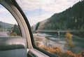
 The North Thompson River as seen from the train.
 -
 North Thompson River as seen from the train.
 -
 The North Thompson River as seen from the train.


