User:Aiapicco/Water conflict
| This is the sandbox page where you will draft your initial Wikipedia contribution.
If you're starting a new article, you can develop it here until it's ready to go live. If you're working on improvements to an existing article, copy only one section at a time of the article to this sandbox to work on, and be sure to use an edit summary linking to the article you copied from. Do not copy over the entire article. You can find additional instructions here. Remember to save your work regularly using the "Publish page" button. (It just means 'save'; it will still be in the sandbox.) You can add bold formatting to your additions to differentiate them from existing content. |
Transboundary water conflicts and their effects on the Environment[edit]
Lead[edit]
Tigris and Euphrates Rivers
Since the 1960s,[1] there has been conflict revolving around water in Turkey, Syria, and Iraq. Turkey, throughout the years, has continuously decided not to follow the 1987 agreement that ensured roughly 500 cubic meters per second of water is streamed down the Tigris and Euphrates Rivers to supply water for the Mesopotamian Marshes and millions of individuals.[2] Turkey deiced to start the Southeastern Anatolia Project or GAP which is to build 20 dams that could hold up to 120 billion cubic meters along with nineteen hydroelectric electricity generators leaving millions of people and wildlife living downstream that rely on both the Tigris and Euphrates Rivers with nothing.
Article body[edit]
Turkey and the GAP Project.
The Tigris and Euphrates River GAP project, which consists of (1.7 million hectares)[3] has exasperated the situation and has created irreversible and future irreversible environmental damage not only to the surrounding countries but to Turkey as well. The GAP project decreased water by 50% from the Tigris and Euphrates Rivers to the surrounding downstream countries, Syria and Iraq. The lack of downstream water has led to many Kurds becoming homeless, increasing water salinity in the Euphrates reaching 1000 PPM and preventing Iraq from returning to rich organic soil used for agriculture. In addition, the lack of downstream water will also prevent natural drainage, including salts and pollution that the rivers naturally got rid of, affecting the health of millions.[3]

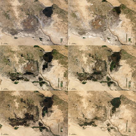
Effects on the Mesopotamian Marshes
The Mesopotamian Marshes, also known as the Iraqi Marshes, saw a considerable decrease during the 1980-1988 war with Iran when Saddam Hussein, the fifth president of Iraq, accused Arab inhabitants of treachery and therefore used water as a weapon to push them out of the Marshes.[4] To get thousands of people out of the area, the Iraq government drained 10% which, used to cover 9,000 square kilometers (3,500 square miles) to 760 sq. km, and in 2005 only gained 40 percent of their original coverage. [3][4]The Third River is a 172 kilometres long project that started in 1992. It involved an additional channel in capturing the downflow water from the Tigris River and moving it across the mashes and the Euphrates River near Al-Qurna. The project forced half a million marshland people to migrate, burnt down the surrounding towns, and polluted the surrounding farmland and water, making the land inhabitable for thousands of species and human life.[3]
Mosul and Haditha Reservoirs

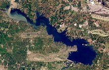
The conflict in Tigris and Euphrates Rivers has resulted in reservoirs decreasing rapidly. In 1985 and 1986, the two biggest reservoirs, Mosul and Haditha, situated in the Tigris and Euphrates, were built to provide hydropower and downstream flow. [5]During the first Gulf War, in 1990 and 1991[6], 3.3km2 of surface area was lost per day in the Mosul reservoir falling from 372 to 346km. On January 25th and February 10th, 1991, the reservoir continued to lose about 3.4 km2 per day of the lake surface, leading to a final surface area of 215 km2 and a volume of 3.3 km3.[5] This was the same time in February 1991 when multiple British bombers sent multiple missiles hitting bridges in southern and western Iraq, killing more than 100 in each attack[7] and affecting water levels. During the same time, between January 17 and February 10th, 1991, the Haditha reservoir, also situated in Iraq, lost an average of 2.5 km2 of lake surface per day and in three weeks lost a total of 21%. In August of 2014, ISIS, a rebel group, captured the Mosul Dam, which Kurdish sources feared would be used to float downstream countries, causing thousands of deaths. [8]The US sent over 130 air strikes to help recapture the dam from ISIS in northern Iraq. [9]The US sent airstrikes hitting the areas surrounding the Haditha reservoir to stop ISIS from capturing another vital dam that is a source for millions.[10] The conflict over the resource in the area caused both the Mosul and Haditha reservoirs to lose surface area at a rate of 2.0km2 a day.[5]
References[edit]
- ^ "Turkey, Syria and Iraq: Conflict over the Euphrates-Tigris | Climate-Diplomacy". climate-diplomacy.org. Retrieved 2022-06-23.
- ^ "Turkey is reportedly depriving hundreds of thousands of people of water". openDemocracy. Retrieved 2022-06-23.
- ^ a b c d Abdulrahman, May F. (2021-08-31). "Effect of Discharge on Water Quality in Euphrates River Between Hit and Ramadi, Iraq". Iraqi Geological Journal. 54 (2B): 101–111. doi:10.46717/igj.54.2b.9ms-2021-08-29. ISSN 2414-6064.
- ^ a b "Iraq's marshes, once drained by Saddam, named world heritage site". Reuters. 2016-07-17. Retrieved 2022-06-23.
- ^ a b c Hasan 1, Mejs; Moody, Aaron 2; Benninger, Larry 1; Hedlund, Heloise 2 1 Department of Geological Sciences (2019-03). "How war, drought, and dam management impact water supply in the Tigris and Euphrates Rivers": 264–279. doi:10.1007/s13280-018-1073-4.
{{cite journal}}: Check date values in:|date=(help); Cite journal requires|journal=(help); no-break space character in|last=at position 6 (help)CS1 maint: numeric names: authors list (link) - ^ "Persian Gulf War | Summary, Dates, Combatants, Casualties, Syndrome, Map, & Facts | Britannica". www.britannica.com. Retrieved 2022-06-23.
- ^ "The airstrike in Mosul was potentially one of the worst U.S.-led civilian bombings in 25 years". Washington Post. ISSN 0190-8286. Retrieved 2022-06-23.
- ^ "Kurdish forces 'break IS hold on Mosul dam'". BBC News. 2014-08-17. Retrieved 2022-06-23.
- ^ "US strikes Islamic State militants at Iraq's Haditha dam". BBC News. 2014-09-07. Retrieved 2022-06-23.
- ^ "US launches airstrikes around Iraq's Haditha Dam". popularmilitary.com. Retrieved 2022-06-23.
