
Talk:Topographic prominence/Archive 1
| This is an archive of past discussions. Do not edit the contents of this page. If you wish to start a new discussion or revive an old one, please do so on the current talk page. |
| Archive 1 |
K2 and Everest
K2 is a on the China Pakistan border, Everest the border of Nepal and Tibet; they are a very long way appart.
- That's right. The prominemce of Everest is 8,850 m (the highest point on its landmass). but although K2 is 8,611 m high, its prominence is only about 6,000 m. (Because you can get from K2 to Everest without descending below 2,000 m if you go along the Karakoram and Himalaya ranges through Kashmir and Nepal. Gdr 15:55, 2005 Mar 23 (UTC)
I don't quite get it - wouldn't this make the whole landmass one big mountain range? --SPUI (talk) 11:53, 20 Mar 2005 (UTC)
- You're right, for the purposes of topographic prominence, each landmass should be considered to be one big mountain range. If you can say in more detail what you "don't quite get" then we could try to improve the article to make it more understandable. Gdr 15:55, 2005 Mar 23 (UTC)
The article suggests K2 is "near the summit of" Everest. The figures above (K2 prominence) would clarify the concept greatly, as I think would starting with the "contour" definition rather than the "col" one. I'll be bold and change it in a few days time. PeterGrecian 13:56, 29 Mar 2005 (UTC)
- The article suggested no such thing. It was the "small bump" that's near the summit of Everest. Anyway, I reworded to make it clearer. However, the numbers given for the prominence of K2 and Everest's South Summit are just guesses. Please replace the guesses with more accurate figures. Gdr 14:44, 2005 Mar 29 (UTC)
Got it!. I've been a bit dim here. However it is much clearer now thanks. Peak Bagger describes three types of prominence; optimistic, interpolated and clean (or pessimistic). K2 is given a clean prominence of 3811 m. The article could be expanded to reflect this distinction. PeterGrecian 14:15, 30 Mar 2005 (UTC)
- But I still wasn't "getting it"! I realised something was wrong when I read "highest col" and saw the diagram showing the lower col for the right hand subpeak. Worse, some web sites say "lowest col" instead of "highest col"! I have rewritten and added a lot. I'm no expert here so most of what I have learned came from the excellent http://www.peaklist.org/theory/theory.html, Prominence and Orometry by Aaron Maizlish. Thincat 12:50, 11 Apr 2005 (UTC)
Aconcagua
This article states currently that the world's second tallest mountain is K2, with 3811m relative height. The list of peaks by prominence, however, (apart from giving K2 4017m rel. ht.), gives Aconcagua second place, with 6962m. I didn't want to just dive in and change the article in case I'd overlooked something, but it probably ought to be changed, right? --Stemonitis 11:05, 26 September 2005 (UTC)
- The article is (correctly) saying K2 is the world's second highest peak in elevation, not prominence. Maybe this should be made clearer though I think the article is OK. Aconcagua, being the highest peak in the Americas, has a prominence equal to its elevation: 6962m (or so!). I expect the prominence of K2 is quite problematic and different authorities may have different opinions. Prominence is the height above its key col and the location of this may be in dispute. However, it would be nice to have a "preferred" value, presumably in the range 3811 - 4017m. It's maybe a pity the K2 article doesn't go into this. However, the present article does give the prominence agreeing with K2, though not, as you say, with List of peaks by prominence, which gives interesting references. The reference in the present article to [1] is also interesting. It gives a "clean" and "optimistic" prominence for K2 thogh the same figure is given for both. Thincat 12:53, 26 September 2005 (UTC)
- Sorry to nitpick, but the article states that K2 is the second tallest mountain, having defined topographic prominence as how tall a mountain is. If it were just in terms of elevation above sea level, then Everest South Peak comes second, unless there's some implicit limit of topographic prominence (e.g. only peaks above 100m rel. ht. count). If tall refers to relative height, then the world's number two is Aconcagua, not K2. I'm not concerned about the differing values for K2's relative height (although it would, of course, be nice to get a single, authoritative figure); I just think that what the article currently says (or seems to me to say) is wrong. --Stemonitis 13:12, 26 September 2005 (UTC)
- I'm with you now and I agree with you! It is indeed poorly expressed for someone just getting here. There are a lot of links to this page and some people will simply want to know roughly what prominence or relative height mean. They won't want to wade through the detail. The first paragraph needs to be really good. Do you want to try a re-write (posting in "talk" first if you like) or are you hoping someone else will pick up on your suggestions? Thincat 13:48, 26 September 2005 (UTC)
- I'll have a think about it, but I'm not sure I'll succeed. I like the old "a way that makes precise the intuition that the world's second-tallest mountain is … not, say, Everest's South Summit", but while people may have that intuition about K2, I'm not sure the same applies to Aconcagua. Like I say, I'll have a think about it and see what I come up with. In the meantime, if anyone finds a really good wording, please don't keep it to yourself. --Stemonitis 14:07, 26 September 2005 (UTC)
I wrote the sentence about K2 and Everest South Summit. The point is that if you believe K2 to be the world's second tallest mountain (rather than Everest South Summit, or even a small bump of snow near the summit of Everest), that's because you have in mind some criteria that a mountain must satisfy to count as a peak in its own right, and not just a subpeak of another mountain; and one of those criteria is having a decent amount of prominence. In other words, we consider K2 to be the second highest mountain because (1) it has enough prominence to count as a peak in its own right; (2) among such peaks it is the second tallest.
I hope no one imagines that the article is trying to redefine "tallest" to mean "greatest prominence"; that would be silly. Gdr 14:24, 26 September 2005 (UTC)
- Ah, so you did mean some cut-off point based on relative height for what counts as a mountain in its own right! I hadn't interpreted the text that way, and it should perhaps be clarified. Incidentally, I don't think it's at all silly to consider "tall" to be equivalent to "greatest prominence"; I use relative height as a means of ranking peaks, not of determining what counts and what doesn't. I like the fact that that gets us away from the arbitrary limits encountered elsewhere. (Is a 913m Scottish mountain really so much less worthy than a Munro? Is a 7999m peak really so much worse than an eight-thousander? Is any peak in the Alps under 4000m inherently inferior? I think not.) An arbitrary relative height limit is not much better than an arbitrary absolute height limit, but if we are to use a cut-off limit, then we should be open about what it is; currently we know it to be somewhere between 10m and about 4000m. Where do you suggest we put it? Or would you rather do without the arbitrary limits? --Stemonitis 15:29, 26 September 2005 (UTC)
- The section "Prominence in mountaineering" in the present article does explicitly say that prominence is an inclusion factor in constructing lists of tall mountains. It is maybe up to the lists to say what inclusion criteria they use. To me also, "tall" means "high in elevation" rather than "high in prominence" (but maybe this should be stated). Where I think there is a problem in the first paragraph is that after saying "how tall a peak is relative to neighbouring peaks" it then says "second-tallest" possibly misleading the reader into thinking relative height is again being meant by implication. Giving the prominence of K2 and South Summit possibly compounds the problem. However, without these figures, the comparison loses its point.Thincat 15:57, 26 September 2005 (UTC)
- Thanks, Thincat, your edits have clarified that first paragraph. I, personally, still don't like these cut-off limits, but since that's the way it's generally done, that's the way it should appear in Wikipedia. Good work. --Stemonitis 15:45, 29 September 2005 (UTC)
A general comment that relates to some of the above discussion: prominence can either be used as a cutoff, for a list that is ranked by, say, elevation, or it can be used as the ranking method itself. Some of the confusion above is due to the page not making this distinction clear. When one says that "K2 is the second tallest mountain" one is using a height-ranked list, cut off by prominence. When one says that "Aconcagua is the second most prominent mountain" (one would never say "second tallest") one is using a prominence-ranked list.
One of the nice features of prominence is that a list ranked by prominence needs no cutoff; a peak with prominence 2000m, say, really is a significant peak, and not a subpeak of anything.
These issues are discussed well in some of the references, but I wanted to make sure that they were explicitly included in this discussion. I would suggest editing the page to make this distinction clear. I agree that the first paragraph, as it is now, in particular can be confusing on this point. I won't edit the page myself for now though.
One more note: a reference might be added about the prominence@yahoogroups.com discussion group, which is a good up-to-date source for prominence ideas and data. --Spireguy 19:17, 7 October 2005 (UTC)
Prominence of K2
First, in response to some earlier talk, I would like to point out that the saddle of K2 is at Mustang Lo, 4594m, and that its prominence is therefore 4,017m. This has now been updated on Greg Slayden's site [here] and afaik is not disputed by anyone. I have corrected this on the main page.
There has been much criticism of the concept of prominence for only ranking K2 22nd in the world, but is needs to be pointed out that K2 belongs to the same (albeit very great) physical range as Everest. You can draw a line from K2 to Everest without anywhere dropping below 4594m at Mustang Lo.
Jonathan de Ferranti
Marilyns and fourteeners
I did another revision of how Marilyns are discussed, which hopefully makes it clear that they are a British concept. (I also clarified this on the Marilyn (hill) page.) To further illustrate regional usage of prominence, I included fourteeners in the US. -- Spireguy 15:29, 27 April 2006 (UTC)
- I like the new wording at this article. I've taken out one sentence at Marilyn (hill), however, because Marilyns are by definition, restricted to the British Isles, so the term cannot be used elsewhere. Apart from that, good work. --Stemonitis 06:29, 28 April 2006 (UTC)
- Thanks, but see Marilyn (hill) and your talk page for a new wording of that limitation of geographic scope---basically quoting your comment above. -- Spireguy 13:58, 28 April 2006 (UTC)
Major revisions to come
I went ahead and revised a lot of this...and then forgot to save it (or it flubbed the save). I'll come back in the next few days and re-enter my changes, and see if people like them. In particular that first paragraph really needs to change. -- Spireguy 22:38, 28 April 2006 (UTC)
OK, I've made some revisions as promised. I think that the intro is clearer now. I revised the various definitions somewhat as well. The biggest change I made was to take out most of the last section, which, now that the early sections are clearer, became pretty redundant. Some of the discussion I took out was of the form "a common misconception is...and here's an explanation of why that is incorrect", which shouldn't be necessary if the original explanation is clear, and isn't appropriate (imo) in an encyclopedia article. (It would belong in a more extended discussion, such as is available in the references/links.) I didn't yet look much at the "Parents" section; I'll probably take a look at that soon as well. -- Spireguy 19:33, 29 April 2006 (UTC)
- That is just great, Spireguy! Since I'm the person who added the "more detailed explanation" in the first place (only a year ago but it seems much longer), I'm delighted to say I think you've done absolutely the right thing. It is much clearer now. I think you have been right to remove the "folksy" bits too. Wikipedia has changed and they are less acceptable now, if ever they were. Thincat 13:44, 3 May 2006 (UTC)
i don't totally get this
is prominence anything like the measure from base to summit? is this a similar concept or something totally different? i noticed on the Mount Mckinley page it says that the mountain has a higher measure base to summot than everest, but everest has a greater prominence. how does this work? Joeyramoney 15:51, 30 May 2006 (UTC)
- No, they are two different measurements. The "base to summit" measure mentioned at Mount McKinley is a slightly vague concept based on the general elevation of the surroundings (the Tibetan Plateau in the case of Everest). Relative height (topographic prominence) on the other hand, is rigorously defined and does not depend necessarily on the elevation of the surrounding land, but rather on the height of the highest col separating the mountain from any higher mountain. The location of the "base" of Everest or of Mount McKinley probably depends on your point of view. Similar arguments lead to Mauna Kea being "taller than Everest" because its base is several kilometres under the sea. --Stemonitis 16:00, 30 May 2006 (UTC)
- well that's just crap. mckinley's a he-man mountain! thanks, though. Joeyramoney 22:03, 30 May 2006 (UTC)
- I would modify Stemonitis's statement to say that "base to summit" is often a very vague concept. For most mountains, picking a unique, universally agreed-upon "base" elevation is impossible. Everest is an example: the "base" could be a certain location close to the north side of the peak on the Tibetan Plateau; it could be a further-away location on the Tibetan Plateau; it could be various places on the south side of the peak.
- It is important that people do not mistake prominence for a (necessarily vague) base-to-summit measurement; that's one reason I made an edit to the intro to this article a while ago, when it had a statement that could easily have been misinterpreted as saying that they were the same thing. Hopefully it's clearer now, although obviously still not completely so. -- Spireguy 02:12, 31 May 2006 (UTC)
- I was trying to be polite! --Stemonitis 07:47, 31 May 2006 (UTC)
Unfortunately Joeyramoney's attitude, right down to the language he uses, reflects a widespread attitude to prominence, even within some circles of eminent mountaineers. Sadly, there is a mindset attitude out there. Also, there can be confusion between prominence in a general sense, and the topographic prominence metric. For example, the high point of the Arabian peninsula is not at all prominent in the general sense, but is ranked highly by topographic prominence because it is the high point of a large land mass.
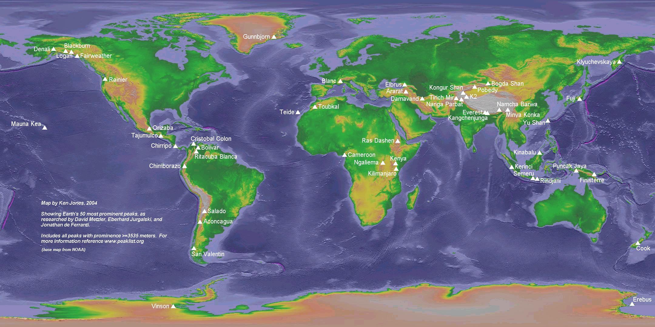
That it is not necessarily a measure of local topography should not detract from topographic prominence. If K2 were higher than Everest, how many more people would have heard of K2 and how many fewer people would have heard of Everest? Answer: very, very many. And are not continental HP's Aconcagua, Denali, Kilimanjaro much better known than most of the entries in the List of highest mountains, which are all in High Asia? Compare that list with a map showing the 50 most prominent. Which better represents the world's greatest and best known mountains? Being high points of geographic entities (e.g. continents, sub-continents, ranges, peninsulars and islands) makes summits worthy, even if they are not locally spectacular.
By the way, I hope Spireguy will not mind if I point out a more localised measure than prominence, by which spectacular mountains score highly, even where they are not the local high points. Viewfinder 12:33, 31 May 2006 (UTC)
RE: Interesting Prominence Situations
Hi gang; Adam, David etc - it's Mike from bivouac; formerly from bivouac, now an ancien terrible in Wiki. Dropped by to see the article; clearer and less confusing than I'd expected ;-P but one idea - maps showing given peaks and their key passes (by whatever term), for instance. But when I saw the "interesting prominence situations" section I thought, hmmmm now about that tangle involving the Champagne, Summit Lake, Rose Lake and Grand Pacific Passes and how long it took to sort that out; and only sorted out in Bivouac maybe, with variations from peaklist.org and your other sites' reckonings, I haven't looked. These are Bivouac's figures, fresh-copied:
- Rose Lake Pass (Fraser-Skeena Pass) 730 m (2395 ft) Prominence (depth) is 3289m below Mount Waddington.
- Summit Lake Pass (Fraser-Peace Divide) 710 m (2329 ft) Prominence (depth) is 4930m below Pico de Orizaba.
- Champagne Pass (Alsek-Yukon Pass) 716 m (2349 ft) Prominence (depth) is 3956m below Mount Fairweather.
- Grand Pacific Pass 738 m (2421 ft) Prominence (depth) is 2289m below Mount Ulysses.
Give or take a few meters and the prominence hierarchies shift radically as you know. We were pretty sure, after much hunting and pecking on BC Basemap around Summit Lake, that it's 710m; Rose Lake is an interpolated elevation but it doesn't seem like it could be much lower; Champagne is an unsurveyed elevation, eyeballed from GEMS/TRIM study and whatever of the several map systems Robin and Fred had around the office; but it's Grand Pacific that's the clincher. In the case of Rose Lake, Grand Pacific and Champagne, ideally there should be on-the-spot readings to make sure; but with Grand Pacific there's that whole glacial-melt issue, and the 738 was only an eyeball off the topos; it could very well be under 720, given the crevasses on the edges of glaciers possible; and once the ice is gone (any time now ;-) ) it could very well be lower than Champagne, which may be over 720 (we chunked 'er down a bit, as I recall, to firm up the sequence; kinda cheated, in other words....). This is fairly technical-specific for newcomers to the issue, but this is primarily for the experienced prominencers who I know are monitoring this page. I should note also that Robin never gave me the time to fix the Fairweather 1 prominence-region boundary, which currently delimits at Grand Pacific but should delimit at Champagne, if these figures are right. I guess it's a done deal now, pending any site-specific elevation surveys but it struck me as an "interesting prominence situation"; not sure how to distill it down for public consumption, though....(and the leg bone connects the knee bone, and the knee bone connects to the etc; sorting out Ratz/In Sloko was a treat, once I got it figured out; and as I recall there were a number of options for Ulysses over on the perimeter of the Stikine basin...).Skookum1 07:51, 27 July 2006 (UTC)
- Hi Mike! I recall researching this a while ago for a discussion on the prominence e-group, and posting some thoughts and topo links to [2]. I think it was agreed that Summit Lake is the lowest and therefore belongs to Orizaba. The other three were less clear. Viewfinder 08:56, 27 July 2006 (UTC)
- Well, in the case of Summit Lake, thanks to Basemap, we have a TRIM spot-elevation. This is not the case with any of the other three; that's the gist of the previous post; and I have my suspicions about Grand Pacific, and would like to see a contemporary satellite photo and spot-elevation for it.Skookum1 15:48, 27 July 2006 (UTC)
Topographic?
I've been working through the term topography (see the discussion under that article for further elaboration), and am in the process of converting many references to topography that deal strictly with relief, to terrain. I don't want to mess with "topographic prominence" without the "page-masters" having in on it... so anyone else interested in changing the title? Looks to me like "Prominence" is the key word, and "topographic" is the disambiguator. Any alternaties? "Prominence (terrain)"?--Natcase 03:35, 17 November 2006 (UTC)
- I'm against using "terrain". I prefer either the current Topographic prominence or Prominence (topography). Googling it shows that "topographic prominence" has quite wide currency outside of Wikipedia (and its mirrors), particularly in the US. If a disambiguator is to be used, I think it should be topographical, not terrain.
- The OED defines:
- terrain A tract of country considered with regard to its natural features, configuration, etc.; in military use esp. as affecting its tactical advantages, fitness for manœuvring, etc.; also, an extent of ground, region, district, territory.
- topography The science or practice of describing a particular place, city, town, manor, parish, or tract of land; the accurate and detailed delineation and description of any locality.
- Neither of these mentions elevation, but, to me (as a native British English speaker — perhaps it has other connotations to an American English speaker), terrain refers more to the natural features of the land: whether it's grassy or heather-clad, steep and craggy or gently undulating, scree-covered or solid rock. But, to me, more abstract concepts such as elevation or prominence which are not local properties of the land, are not terrain — they're topography. I think the two definitions, above, back this up, at least to some extent. — ras52 15:55, 17 November 2006 (UTC)
- I am also against using "terrain." First, in the specific case of prominence, the full term "topographic prominence" does have wide currency. Alternates such as "prominence (terrain)" do not. Second, more generally, I don't see why "terrain" would be preferred over "topography" when the sense meant is "relief". The word "topography" is very often used in the specific sense of measurement of vertical relief, e.g. in the term "topographic index," e.g. here. (In fact topographic prominence is a specific example of a topographic index.) The word "terrain" has meanings that extend beyond "relief", to the quality of ground (e.g. "I walked over rocky terrain") as much or more than the word "topography." So why the big push for a change?
- Also, the OED is not a particularly good reference for this issue, since it has no recent citations for "topography". -- Spireguy 22:46, 17 November 2006 (UTC)
Recent copyediting
Thanks to Birdhurst for some good copyediting. I did some more, and moved a few things around. Some explanation: (1) the K2 example wasn't really doing any good anymore in the intro, so I moved it down. Also, if we aren't going to have a concise version of the definition in the intro then we should get right to the main definition section immediately. (2) I reverted or semi-reverted some changes that I think Birdhurst did for style but imo came at the expense of clarity. E.g. it is important that the different definitions are equivalent: there are not three different notions of prominence, just three different ways to define it. Also, some of the streamlining of the phrasing resulted in a possible confusion of what is being modified; I changed those. -- Spireguy 20:24, 31 December 2006 (UTC)
Prominence parentage
Can anyone supply a 100% rigid definition of prominence parentage? The definition of island parentage seems to me to be rigid, but the definition of prominence parentage does not. What if the continuation of the ridge from the col diverges? What about summits that are slightly displaced from the main ridge?
- Quoting [3], "Prominence helps solve this perceptual problem: we can look to the first higher line parent that also has more prominence as a second kind of natural "Parent". The Prominence Parent (PP) would be the first summit across the key saddle that has more prominence". And I think a line parent is a peak on a line of the ridge network that connects the peak in question to the island parent. "The Ridge Network, composed of summit, saddle and ridge elements is much less well described in the earth science literature, though its mathematical form is known in Morse topology. The Ridge Network forms the delimitations of all drainage basins. A continent or island is composed of one central ridge network, and many channel networks that radiate out from the ridge network like petals". So, I suspect this prominence parent may well be mathemetically well-defined. However, I don't think the definition is really very helpful in some cases. What if, as you say, there is a high, prominent peak fairly near the peak in question but which is not on the ridge line to the island parent? My feeling (as a layman), is that definitive parentage is not possible over large distances. Key col and island parent (even when they are remote), have pretty clearcut definitions but that is a bit of a mathemetical freak. I think the article reads rather well on this. Thincat 10:55, 15 May 2006 (UTC)
- There are a lot of subtleties to the notion of "parent", and the notion has been discussed at great length on the prominence (..at..) yahoogroups.com list. In my latest revision I did not try to address these subtleties, most of which are not appropriate to an encyclopedia article. However I think it would be good to flesh out the PP and HP subsections a little to make more precise the various possible definitions.
- The definition quoted above, at peaklist.org, does result in an unambiguous definition, but it is not the only possibility. If, as mentioned above, there is a high-prom peak that is not on the ridge network path to the island parent, it will not be the PP by this definition, even if it is quite close to the peak in question. Many people would like it to be the PP in this situation, so a different rule would be necessary; there are a few to choose from.
- I personally agree that definitive parentage is impossible over large distances; put another way, there is no notion of parent that satisfies every reasonable property that one would want for such a notion, in all cases. But since it is a very useful notion for short distances, and certain extensions of the notion have some usefulness even at long distances, many people want to have a version of parentage that is applicable in all situations. -- Spireguy 18:35, 15 May 2006 (UTC)
I'm really sorry that it's more than a year since you wrote these messages, but I hope you two are still around. I've tried to expand on the notion of 'prominence parentage' myself and give it a clearcut and unambiguous defintion which might nevertheless take a bit of thinking about. Please talk to me if you don't understand it or think it can be made simpler.
(After all, I was the one who made the list of peaks by prominence in the first place, I should at least try to explain what the parent idea I used for it means!) --Mark J 15:55, 26 May 2007 (UTC)
Clarification about Panama Canal
I have added clarification about the relationship between McKinley (Denali)'s saddle and the Panama Canal. The article contends that a sea level rise of 56 m would divide North and South America. In fact, 26 m would be sufficient, since it would flood the Gaillard Cut. I have added this fact to the article 19:02, 7 March 2007 (UTC)
- What's the elevation differential on the Lago de Nicaragua crossing; I recall that it's not that much different, perhaps a bit higher since the Gaillard cut, but originally it was lower than Panama; the route wasn't used because it was longer or something, but no rails would have been required, and I think only one or two locks.Skookum1 19:24, 7 March 2007 (UTC)
I have amended the above mentioned edits, because, for the purposes of topographic prominence, man made constructions are not included. Perhaps the issue does need better clarification, but the 26 m rise would not disconnect the Americas, it would merely raise the canal's water level. To completely disconnect the Americas at this location, a rise to about 100 m would be required. Viewfinder 03:21, 8 March 2007 (UTC)
If "topographic prominence" does not take into account man-made construction, then the article contradicts itself. The article gives 4 definitions of topographic prominence, NONE of which mention man-made construction. If, indeed, topographic prominence does not take man-made constructions into account, and instead uses some idealized notion of the earth's surface, that MUST be noted in the definitions given. Otherwise, the definitions are useless. 17:29, 8 March 2007 (UTC)
Do any of you realise how silly this all looks to anyone except people who spend their time doing pub quizzes?? Don't you have anything better to do with your time? Excalibur 23:34, 2 June 2007 (UTC)
- This section is about whether or not we should take man made topography into account when we calculate topographic prominence. Let's keep it that way. Thanks. Viewfinder 22:30, 3 June 2007 (UTC)
- First I'll remind Excalibur to be civil and avoid personal attacks. Second, the issues about man-made versus natural topography are minor side issues, which is why they are not specifically addressed in the basic definitions. -- Spireguy 13:55, 5 June 2007 (UTC)
- Minor side issues? I beg to differ. As someone who has made several "Top 50" lists of states in the southeastern US, I can tell you man-made changes are not minor. Due to mountaintop mining, entire Top 50 state lists are now completely different than they would have been 100 years ago. In fact even the Cumberland Gap is now the key saddle for a different mountain than it used to be. It used to be the key saddle of Bryson Mtn, TN, now it is the key saddle of Log Mtn, KY (Bryson was lowered by mining). I could give hundreds of examples like this. But the real issue is whether topographic prominence is really the "well-defined" mathematical measure that its supporters so loudly claim. If prominence supporters try to ignore man-made changes (which is very difficult to do in practice), then the whole exercise loses its connection to the REAL earth, and then it really becomes pointless. 128.173.49.45 22:59, 5 June 2007 (UTC)
- Let me clarify. My primary point was that the idea of prominence and how it is related to the height function of a landscape is one issue, whereas the exact details of a particular landscape are another. The former is the crucial issue for giving the definition and for understanding what prominence means; that is why the issue of how to treat man-made alterations in the landscape is not addressed in the first part of the article, which bothered Excalibur.
- As to the real-world importance of man-made changes, you correctly bring up the issue of the Southeast US. I agree that that is a region in which the question is not minor at all, when it comes to actually assigning prominence values. Fortunately, the southeast US is still an exception in this regard, as far as I know, especially if one considers the worlds high-prominence peaks, as mountaintop mining is still relatively rare. For the high-prominence peaks, the issue is more about saddle elevations, and even then, there are not many mountains affected, and those affected are changed by a small percentage. Those are the other reasons why I referred to the issue as "minor", but in light of the southeast US facts, I retract the word "minor".
- As to the philosophical issue of whether man-made changes should be included, and how drastically ignoring them could unmoor the concept from reality, I have two responses. The first is my personal one: I have always strongly believed that man-made changes should be included, and that trying to fix an idealized past landscape to measure is not appropriate. That is especially true for mountaintop removal, where the peak height changes, not just the prominence (as in the case of canals in saddles). So I agree with you, personally, on that point, although I probably wouldn't put it quite as strongly.
- Second, however, the appropriate question for Wikipedia is to ask what is the community standard, as defined by the sources: since the sources (e.g. peaklist.org) typically choose to ignore man-made changes, Wikipedia should follow suit, even if it does not please me or other editors. Suggestions that this convention is inappropriate are better directed toward the people who do the research, write the books, and put up the web sites. For myself, as a member of that community, I argued some time ago for including man-made changes, but as it is not a major issue for the peaks in which I am most interested, I desisted. -- Spireguy 20:13, 6 June 2007 (UTC)
Changing heights
- Fine. Given that sea levels are rising, and mountains are constantly changing height for perfectly natural reasons, this whole article could be a recipe for an iterative sequence of miniscule edits - a sisyphian task. My point is...why bother writing it in the first place given that it will be out of date by next year? Precise measurement of something as transient as mountains isnt important - as a climber I'm happy if there is a rough contour to guide me, but that's good enough. What benefit or use is there in precision - the case hasnt been made in the main article imho Excalibur 22:45, 3 June 2007 (UTC)
- The sea is not rising that quickly, and with the exception of some volcanoes, heights expressed measured in integer metres (as opposed to millimetres) are stable from year to year. Also, your comments are applicable to height and prominence based lists alike; they criticise the whole concept of mountain metrication. Evidently, you are not a list ticker. That's fine by me. But according to the records, more than 3,000 hikers have ticked all of Scotland's Munros, and 169 have climbed at least 600 Marilyns [4]. Mountains lists with both absolute and relative heights and will remain on Wikipedia, but you can choose to ignore them. Each to his own. Viewfinder 23:55, 3 June 2007 (UTC)
Whitney - to Pico de Orizaba or Popocatepetl?
Just asking, as Bivouac/Canadian Mountain Encyclopedia says the parent for Whitney is Popo, not Orizaba. They give the "Playas-Pride Pass" as the col but their system is malfunctioning right now and I get a script error when I try to find out where that is; I'm surprised its col is on the Continental Divide rather than en route to it, but I haven't examined the prominence data for California in detail; I know I got incredibly lost in Nevada, Utah and Colorado trying to work my way through the maze of semi-flat regions and indeterminate drainage basins....Skookum1 08:23, 8 March 2007 (UTC)
- The article says Orizaba is the encirclement (or island) parent whereas Bivouac says it is the line (or prominence) parent [5]. See [6]. Popocatepetl is closer than Orizaba. I suspect this may explain the difference. Thincat 12:21, 8 March 2007 (UTC)
New defintion of prom parentage
For those of you who aren't sure what it means (and I can understand that!) I've tried to expand on the notion of 'prominence parentage' myself and give it a clearcut and unambiguous defintion, by using the territory concept, which might nevertheless take a bit of thinking about. Please talk to me if you don't understand it or think it can be made simpler. Don't hesitate to muck around with it as well.
(After all, I was the one who made the list of peaks by prominence in the first place, I should at least try to explain what the parent idea I used for it means!) --Mark J 15:58, 26 May 2007 (UTC)
Merits of Prominence should be objective
I see that of one the claimed "merits" of prominence is that "The peaks listed are usually amongst the best viewpoints, especially in clear weather." The source that is cited is "The Relative Hills of Britain". This statement (and the citation) are problematic for several reasons.
First off, whether any particular point is a good viewpoint is purely subjective, and therefore makes a weak statement in support of prominence.
Second, the cited "Relative Hills of Britain" deals only with hills in Britain, so can one reasonably assume that this statement applies to mountains in general, all over the world? If one chose another small country instead, say, South Korea, then the statement relating prominence and viewpoint would no longer be true (based on Chris Upton's trip reports of South Korean 2000ft prominence peaks).
Third, "The Relative Hills of Britain" was written to promote prominence, so can it be considered an unbiased choice? Please see Wikipedia:Verifiability, which states that "Articles should rely on reliable, third-party published sources with a reputation for fact-checking and accuracy."
Fourth, it has been noticed even in the prominence community that there are many situations in which high prominence has no correlation at all with good views. Examples are highpoints of plateaus, and island highpoints. This was one of the reasons that David Metzler started working on a alternate measure, spire measure, that directly factors local topography into the calculation, which prominence does not.128.173.49.45 21:38, 17 July 2007 (UTC)
- As the editor who made the viewpoint claim, and created both the merit and criticism sections, I must respond to its above criticism. It seems to me that an open view is intrinsically a good view, but perhaps we should replace "best" with "most open", as there are some who may prefer a typical downtown ground level New York City view. That prominent summits usually make open viewpoints is implicit from the definition of prominence; the views are unobstructed by local topography, which is, by definition, lower than the viewpoint. Exceptions can occur if there is a very large summit plateau, or local summit vegetation, but few summits have sufficiently large plateaux, and the soil, exposure and climate borne by most summits mean that they are not inclined to support obstructive vegetation. In the UK, no P600m summit view is obstructed by a plateau or by vegetation, and very few P150m summit views are obstructed.
- On the specific points: I think that it is intrinsic that an open viewpoint is a good viewpoint, both in Britain and elsewhere. I do not think that citing a pro-prominence source in a pro-prominence section contravenes WP:V. Please note that the words "usually among" are used, but the word "necessarily" is not.
- Please can you source your claim that it has been noticed within the prominence community that there many situations in which high prominence has no correlation at all with good views. As for spire measure, its correlation with view quality probably is stronger than that of prominence, but that does not logically render the claim that you are challenging to be incorrect. Viewfinder 04:01, 18 July 2007 (UTC)
- I'm not an expert on this topic, so just a point - many of the mountains in the eastern United States are covered with dense forest. Some are so flat that it'd be hard to know where the high point is if it weren't marked, and there's no view at all unless there's a clearing. Another point is that while high points may give the most distant and widest views, for scenic splendor a position near the base looking up at a handsome pinnacle is usually more aesthetic, IMO. ·:· Will Beback ·:· 05:08, 18 July 2007 (UTC)
- Speaking as the aforementioned David Metzler, yes, spire measure was developed partly out of a response to situations where the prominence and "impressiveness" of a peak do not match. (Credit needs to go also to Bob Bolton and Edward Earl.) However I agree with Viewfinder that we should focus on prominence here.
- As to the "best viewpoint" statement itself, I agree with the anon IP contributor that "best" is a subjective, value-laden word, which is unlikely to be appropriate in Wikipedia even with good sources, and definitely not with only one source which cannot be considered completely unbiased. (I'm not saying that Dawson is an inappropriate source; I'm saying that the standard of verifiability/credibility needs to be higher when dealing with subjective issues, which are inherently controversial.) I don't agree with Viewfinder that an open viewpoint is a good viewpoint, especially when other factors may intervene. A higher-elevation peak with lower prominence may have a more obstructed view than a lower-elevation peak with higher prominence, but many would prefer the view from the former. Many other factors could also come into the subjective determination of "good viewpoint."
- I think that the statement can be replaced by, say, "The peaks listed tend to have unobstructed views over long distances, except in regions where only the highest summits are above the tree line." I'll try that and see how people like it. -- Spireguy 15:06, 18 July 2007 (UTC)
- While I'm looking at this, I'll note that the last point under "merits" is also pretty mushy; its main claim is simply that prominence lists provide an alternative list to height lists, which is fairly obvious. The rest of it, about fitness etc., is not special to prominence, and would apply to any other alternative list. So I would suggest dropping this point altogether, or rephrasing it to just state the main point that it's nice to have alternate lists. -- Spireguy 15:15, 18 July 2007 (UTC)
- This is what the Dawson reference actually states: The majority of Marilyns provide splendid views in favourable weather. I think that comment is generally applicable to high prominence summits worldwide, and should be quoted. I don't think many would dispute it. I concede that there is more of a tree cover issue in countries other than Britain, especially the eastern US; we can continue the debate about how, if at all, this should be pointed out. Re the last point, please don't let's drop it altogether. Viewfinder 16:20, 18 July 2007 (UTC)
- Thanks for clarifying what the reference says; certainly since it doesn't mention tree cover, my version doesn't quite work. However (1) I still think it's important to use a high standard for references where subjective value judgements are involved, so I still would say that "best" or "splendid" or other terms are not apppropriate. (2) It's important to note that the overall issue here is what the merits of prom lists are, relative to other kinds of lists, particularly height lists (the default). Dawson does not explicitly state, nor is it clearly true, that the majority of Marilyns (or other high-prom summits) provide "better" views than peaks chosen in a different way, e.g. high-elevation peaks. -- Spireguy 17:10, 18 July 2007 (UTC)
- I like the way you have phrased the statement about viewpoints, David. It makes a lot more sense now. For the sake of this discussion, it should be pointed out that a high-prominence peak merely needs to be higher than surrounding peaks to get the prominence, but it need not be higher by any minimal amount. Thus there are many instances when one peak is surrounded by peaks that are just slightly lower, thereby still obstructing the view. To make matters worse, due to faulty human perception, the surrounding peaks will often actually look higher. However, the point about line-of-sight is still probably true in most cases, so we can let the statement stand as it is.128.173.49.45 18:08, 18 July 2007 (UTC)
So?
I have a couple questions. First, regarding this statement in the article: A mountain that appears to be highly prominent from local viewpoints may not be ranked highly by topographic prominence, because high passes may connect that mountain to higher mountains in the same range. Okay, so the mountains are in the same range, what difference does that really make, isn't that the point of prominence, to measure how one may go to higher altitude along a route of prominence? The South Summit has a prominence value and it is in the same range as Everest. I don't understand the point of this statement. Second, what can be said about AMS and prominence? It appears to me that prominence would seem to negate the whole necessity of acclimitization. Maybe I'm reading too much into it, but it certainly seems that way. It still seems to me that elevation is of greater importance than prominence as elevation includes far more factors regarding safety, verticality, acclimitization, etc. for mountaineering. --Bentonia School 04:11, 23 August 2007 (UTC)
- THe above statement was in the criticism section and is a valid criticism. The value of prominence lies in the fact that the status of a mountain is enhanced by being the highest point of a range or any other physical entity. If Everest's South Summit were its highest then that summit would be the goal of all those climbers. Mount Washington is 1917m high. So is the highest point of a parking lot in downtown Colorado Springs. Elevation isn't everything. Even lists ranked by elevation have to use prominence or something similar, otherwise their length would be indefinite. A good mountain to climb does not necessarily have to need acclimatisation, and regarding your point about safety, climbers die in Scotland too. Viewfinder 13:11, 23 August 2007 (UTC)
- "A good mountain to climb does not necessarily have to need acclimatisation" And I didn't suggest such. --Bentonia School 16:06, 25 August 2007 (UTC)
- To further explain the statement in the article: the criticism is that topographic prominence does not exactly correspond to visual prominence/impressiveness. A classic example is El Capitan, which is strikingly impressive from below, but has very little topographic prominence. While this criticism is valid, it does not negate the importance of topographic prominence; it just says that it does not do everything one can ask from a measure of mountains. That's not surprising, since there is no mountain measure that has all desirable features; different measures quantify different aspects of a mountain. A note about the article itself: given that you (Bentonia School) find that statement unclear as it is written, maybe we should clarify it further in the article.
- Regarding elevation versus prominence: that is related to another valid comment about lists ranked by prominence. Namely, prominence does not correlate exactly to climbing difficulty. There are plenty of easy, high-prominence mountains (e.g. Mauna Kea), and hard, low-prominence mountains, e.g. Lhotse Middle. Again, this is not surprising: prominence is not supposed to measure climbing difficulty. It has some correlation with it, but that correlation is far from perfect. As you point out, pure elevation does correlate strongly with climbing difficulty; but that correlation is also far from perfect, e.g. Cerro Torre versus Aconcagua.
- To sum up: if one assumes from the outset that topographic prominence is supposed to measure something that it doesn't (e.g. visual impressiveness or climbing difficulty) then it will appear to be highly flawed. But it's important not to make that assumption. I hope that clarifies the issues that you raised. -- Spireguy 15:17, 23 August 2007 (UTC)
- Good explanation. Thank you. --Bentonia School 16:10, 25 August 2007 (UTC)
- This defined measure of a summit is properly called topographic prominence to distinguish it from other, often subjective, measures of prominence. --Buaidh 17:26, 23 August 2007 (UTC)
Alternative Definition
The purpose of the 'prominence' concept is clearly to have an objective measure stick for the degree in which a (named) mountain summit 'sticks out' in the landscape. I believe the current definition, which defines prominence as the lowest contour line that encircles no higher peak than the summit concerned, does not do this purpose justice, as indeed e.g. Mt Mckinley would have a prominence al the way to sea level, whereas there are cols at a much higher level. I therefore suggest an alternative definition: "The lowest contour line that encircles a named mountain, and no other named mountain". With 'named' I mean any geographic feature that in the English language features the connotation 'peak', 'mountain', or 'summit' in its official name. For Mt McKinley this would mean that the prominence only goes to the col with Mt Hunter, far less the the current value of its prominence. — Preceding unsigned comment added by Tavernsenses (talk • contribs) 07:49, 4 January 2012 (UTC)
A question about original research on certain mountain lists
The following is copied from Wikipedia talk:WikiProject Mountains: I want to bring up an issue that has been bothering me for a while. User:Buaidh has been putting in a lot of good work on creating various mountain lists, such as Mountain peaks of North America and Mountain peaks of the Rocky Mountains, among others. However I'm concerned about one of the statistics that Buaidh includes in the tables, namely the product of Topographic prominence and elevation, which Buaidh refers to as "summit eminence." In my opinion, both the inclusion of this statistic and the term "summit eminence" are original research. Note that WP:NOR excludes material if "it defines new terms" or if "it introduces an analysis or synthesis of established facts, ideas, opinions, or arguments in a way that builds a particular case favored by the editor." The former covers the term "eminence" and the latter covers the concept itself and its inclusion in the tables, which implies an importance for the particular combination prom*elev which is not justified by any reliable source.
I've noted to Buaidh that I personally like ranking mountains by prom*elev, but that doesn't matter, since it isn't done in any source that I know of. Rather than being bold and deleting much of the info in Buaidh's tables, which I thought would be rather rude, I wanted to get some more input from this group on the issue. (My apologies for those who read this twice.) Thanks -- Spireguy 14:53, 28 August 2007 (UTC)
It looks like the discussion on this will take place at Wikipedia talk:WikiProject Mountains#Lists in Infobox, so please direct all comments there. -- Spireguy 21:48, 28 August 2007 (UTC)
Why Sea Level?
This may be a sort of specious comment, but if we are talking about topological prominence of land formations, why does the ocean get treated as though it is made of land. Shouldn't the topological prominence of Mauna Kea (and other island peaks, continental islands included) be measured from the highest col on the sea floor? Mention is made of the "rising sea model," and, in this talk page, of the rising sea level. I wonder about the lowering sea model. Again with Mauna Kea as the example, how low would the Pacific Ocean have to drop before Mauna Kea was not the highest peak on its landmass? maxsch (talk) 21:35, 28 April 2008 (UTC)
- There are two varieties of topographic prominence: wet prominence and dry prominence. Wet prominence is the more commonly used topographic measure. Wet prominence assumes that the surface of the earth includes all permanent water, snow, and ice features. Thus, the wet prominence of the highest summit of an ocean island or landmass is always equal to the summit's elevation.
- Dry prominence ignores water, snow, and ice features and assumes that the surface of the earth is defined by the solid bottom of those features. The dry prominence of a summit is equal to the wet prominence of that summit unless the summit is the highest point of a landmass or island, or a summit surrounded by snow or ice. If a summit is completely surrounded by a water, snow, or ice feature, the dry prominence of that summit is equal to the wet prominence plus the depth of the highest col.
- The dry prominence of Mount Everest is equal to its wet prominence (its elevation, or 8850 m) plus the depth of the deepest hydrologic feature (the Challenger Deep at 10,911 m), or 19,761 m. The dry prominence of Aconcagua is equal to its wet prominence (6962 m) plus the depth of the highest col of the Bering Strait (about 50 m), or about 7012 m. --Buaidh (talk) 21:58, 28 April 2008 (UTC)
- Buaidh is quite correct that it is possible to calculate "dry prominence", and various people have looked into such calculations. However dry prominence has very little significance for the visual, cultural, or mountaineering aspects of a peak, which are very relevant to how prominence is used. It is also arguably more artificial, as it makes an unnecessary distinction between rock/soil/land and water/ice/snow. So it's usually considered esoteric even to prominence enthusiasts.
- Note that Antarctica, and to a lesser extent Greenland, would have drastically different prominence data under a "dry" (including no ice/snow) model.
- It's important to distinguish between the illustrative picture of the "rising sea model", which is just intended to explain the idea of prominence, and the dry prominence model. For example, the prominence of K2 is significant even though the sea will never rise nearly to the key col for K2.
- Thanks for the explanations, that's very helpful. I see how dry prominence is less useful as a cultural measure, but do you think that the article (called "Topographic prominence") should at least mention the idea of dry vs wet prominence. I'm sure that topographic prominence is also relevant to undersea land formations, and Mauna Loa, for example, could then have Mauna Kea as a parent, certainly a geological truth. maxsch (talk) 16:15, 29 April 2008 (UTC)
- Wet prominence and dry prominence are the same for all but a handful of continental summits. The dry prominence of island summits and summits in Antarctica and Greenland can be very much greater than their wet prominence. Submerged seamounts can have very substantial dry prominence and topographic isolation. Wet prominence is very appropriate for mountaineering, but dry prominence can also highlight extremes of topography. See Extreme Geography. --Buaidh (talk) 19:33, 29 April 2008 (UTC)
- I added a short section to the article explaining the difference between wet and dry prominence. --Buaidh (talk) 21:01, 29 April 2008 (UTC)
- Thank you for this interesting section. Can you provide a reference for the terms "wet" and "dry" prominence and their meanings? I am merely suggesting that a reference should be supplied but other editors might think a reference is essential. I understand all this is a logical deduction but WP should perhaps be following established usage in this area. The whole article is rather weak on references but happily this does not seem to have caused too much argument. Thincat (talk) 14:14, 30 April 2008 (UTC)
"Debates" section
See User talk:Spireguy for a discussion of why I put the {{refimprove}} tag on that section. -- Spireguy (talk) 22:17, 8 October 2008 (UTC)
Re "key cols" and List of mountain passes
I'm wondering what to do for hjeights of land which are passes, but are not so officially named and so not (at present) on List of mountain passes. I'm thinking the Rose Lake Pass/Bulkley-Endako Divide, Summit Lake/McLeod Lake and the Okanagan-Shuswap divide at Spallumcheen; none of these are passes, though they are important prominence cols (for Waddington, Orizaba and Rainier respectively, I think) and "mountain passes" seems awkward; but they are notable and in a technical sense are passes; just plopping this here for further discussion/points.Skookum1 (talk) 23:30, 8 October 2008 (UTC)
Example of Prominence as an excellent metric to create peak lists
A world list of most prominent peaks corresponds to a Seven Summit list provided that all seven selected mountains have key saddles at or only slightly above sea level and are well-separated from each other.
The logic for this statement is available, see Seven Summits Essay Countyhighpointer (talk) 18:50, 9 October 2008 (UTC)
- Unfortunately Pico Cristobal Colon and Mount Logan, which rank 5th and 6th by prominence respectively, are not continental high points, however much we tinker with continental boundaries. Viewfinder (talk) 18:58, 9 October 2008 (UTC)
The key phrases are "key saddles at or only slightly above sea level" and "well-separated from each other". The longwinded explanation follows. In it, the exclusion of Pico Colon and Mount Logan will become clear.
1) "key saddles at or only slightly above sea level"
This stipulation is needed because two mountains separated by a high elevation saddle do not correspond to the highpoints of two continental landmasses. Continents are separated by water, and, barring that, it is logical by extension to separate continents (hence defining them from a prominence perspective) by the lowest available intervening terrain.
As an example, the key saddle for Mont Blanc is near sea level at 371 feet (113 meters). The key saddle for Mount Elbrus lies at 2,956 feet (901 meters). Earth's oceans need rise only 400 feet for Europe to be separated from Asia at Mont Blanc's key saddle. The oceans would have to rise 3,000 feet for Europe to be separated from Asia using Mount Elbrus' saddle.
Hence from a prominence aspect Mount Blanc is the European highpoint.
2) "well-separated from each other"
This eliminates Pico Cristobal Colon of Colombia, Earth's fifth most prominent peak; and also Mount Logan of the Yukon Territory in Canada, Earth's sixth most prominent peak.
Pico Colon is too close to higher ground, as Chimborazo in Ecuador, to be considered a continental highpoint based on solely a prominence criterion. Such a continent would comprise only Colombia. Similarly, Mount Logan is too close to Mount McKinley in Alaska. Were it to define a "continent" then Mount McKinley's "continent" would comprise only Alaska. No reasonable person would consider Colombia or Alaska as continents. Hence Colon and Logan are not reasonable candidates for a Seven Summits list based on prominence.
Furthermore, even if one does not accept their exclusion on the grounds of proximity to higher peaks; Pico Colon and Mount Logan have high elevation saddles connecting them to higher ground. Then, by the first criterion (a near sea level saddle), both of these peaks are excluded anyways.
Pico de Orizaba of Mexico is also eliminated due to a 2,300 foot (700 meter) key saddle with Mount Logan.
Thereby through the use of two criteria world ranked prominences 5 (Colon), 6 (Logan), 7 (Orizaba), and 10 (Elbrus) are eliminated. The resulting peak list contains summits ranked 1-4, 8-9, and 11 - and is identical with the traditional Carstensz variant of the Seven Summits with the replacement of Gora Elbrus by Mont Blanc.
One may debate the merits of these two criteria. However they are based on exactly what is required to define a continental landmass: a low key saddle to higher ground; and sufficient area to be considered a continent as distinct from an island. 66.75.51.144 (talk) 20:00, 9 October 2008 (UTC)
- Assuming that, put into a nutshell, you are claiming that Everest/Aconcagua/Denali/Kilimanjaro/Vinson/Carstensz/Blanc is correct from a prominence point of view, then I agree. A link pointing that out may be OK at Seven Summits may be accepted. But Messner's Seven Summits list makes sense from a political point of view, in that the local populations of the Caucasus and West Papua consider themselves to be European and Australasian repectively. Whatever the commercial atlases, who mostly copy each other, may claim, the continental partition of New Guinea seems to most Seven Summiteers to be nonsense from a topographical or political point of view. That is why they have rejected it.
- Viewfinder (talk) 20:23, 9 October 2008 (UTC)
Correct - one applies the two criteria as one goes down the world prominence list, and the first seven peaks satisfying the criteria form the Seven Summits. It is of note that a co-worker (Edward Earl) independently reached the same list years ago. That two people would arrive at the identical, prominence-based list without correspondence speaks volumes for its sanity.
I can certainly incorporate into text your statement that the inhabitants of New Guinea consider themselves to be Australasian. However I would first like you to provide evidence for that statement - and analogously for the peoples of the Caucasus.
The resulting logic for generating a politically-based Seven Summits list would then change - and, in theory, the Messner variant of said list would correspond to a politically-based continent definition... with the Bass variant corresponding to a strict geographic continent definition (no change there). Countyhighpointer (talk) 21:37, 9 October 2008 (UTC)
- It seems to me evident enough that West Papua is ethnically and culturally closer to Papua New Guinea than other parts of Indonesia. That the Georgians consider themselves to be European does not need citing, and if the south side of the Caucasus is considered to be in Europe then ditto the north side or Europe becomes discontiguous. Viewfinder (talk) 14:25, 11 October 2008 (UTC)
I agree that culturally Irian Barat ("West Irian"), as the western part of New Guinea currently owned by Indonesia is most closely allied to Papua New Guinea from a cultural perspective.
The essay is designed to consider **all possible** means by which a Seven Summits list can be generated - and this concept is completely independent of a climbing community's existence - let alone "approval". That is why such unique concepts as using tectonic plate highpoints and using topographic prominence are included: Mr. Bass had several possible means of defining what is meant by "continent", and he chose the most obvious definition based on continental outlines. From a purely theoretical viewpoint all of the remaining definitions are equally viable.
Then, given this all-inclusive concept, it behooves me to split-out a cultural definition for Oceania as separate from a political definition thereof. The ramifications are simple - for "cultural/ethnic Oceania" Puncak Jaya ("jewel summit" in Indonesian) is the highpoint, corresponding to the Messner Seven Summit list. For "political Oceania" Mount Wilhelm is the highpoint, and as promoted by John Christiana who climbed it instead in his Seven Summits quest. The political version is well documented by commercial atlases, who I admit nonetheless probably just copy one another.
Some atlases portray world regions in specialized maps such as language families, religion, and, yes, ethnicity. It would be interesting to examine some high-end atlases to learn what the division is according to these "experts".
I believe that political and cultural/ethnic Europe can be made to coincide for the essay's purposes - and similarly for the remaining continents. Interestingly, Antarctica has no culture except that of science. If one can call that a "culture" than a culture-based lists maintains a count of seven.
Again, the essay was never designed to compete with or negate existing definitions for the Seven Summits. That would indeed constitute a most minority opinion. No sir - the essay is a study of all possible means by which a Seven Summit list could be generated; with each list based on its own unique criterion.
As a completely separate question, one that I pose "tongue-in-cheek", how many of the Seven Summits must I climb in order to become an "authority" on the subject? This is relevant to linking my essay, yes? Are all seven required? How about six? Or is a simple majority sufficient as four peaks? I am not trying to be facetious here - only slightly amusing. 8-)
Sincerely, Countyhighpointer (talk) 18:13, 11 October 2008 (UTC) (Adam Helman)
"Topographically awkward" examples
In this edit a user has requested clarification of "Normally it will suffice to find the nearest higher and more prominent neighbour. However, some regions are topographically awkward." I'm in a bit of a rush so I'm putting some thoughts here rather than trying to formulate a suitable paragraph for the article. If no-one has beaten me to it when I get home next week, I'll try to put something in the article.
Examples can be found by looking at cell maps such as this one of California or mine of Wales. Both maps show multiple levels of prominence cell — 2900 ft and 5000 ft in the former; 150 m, 300 m, 600 m and 900 m in the latter. Examples of this "awkward topography" can often be found by locating low-ish prominence mountains that are near the boundary of a large prominence cell for a distance peak. (Sorry, that's not very well explained.) A concrete example: the parent of Plynlimon (in the Cambrian Mountains in mid Wales) is Pen y Fan (in the Brecon Beacons in south Wales); however the nearest higher and more prominent neighbour is Cadair Idris (in southern Snowdonia). This works because Plynlimon is at the far end of a long ridge spanning south and mid Wales.
— ras52 (talk) 08:12, 16 April 2009 (UTC)
Kilimanjaro - Child of Everest!?
On the talk page of List of peaks by prominence, I posted a comment in Oct 2011 to which Viewfinder kindly replied that "You are not alone in your sceptical view, but by the well established mathematical definition of prominence parent, Everest is Kilimanjaro's parent. You should take your case to the topographic prominence discussion page, as it applies to the whole concept of prominence parent, not just Afro-Eurasia.". I don't wish to start an elevated discussion on the matter (and I seek no argument with contributors obviously far more expert than I on the subject), but I hope you might find my (typical?) layman's view interesting - my point being that linking some prominences can stretch the readers' credulity too far. Allow me to repost my Oct 2011 comment here, which was (in full):
I read the (List of peaks by prominence) article, and then the talk page, and then read a separate article about Afro-Eurasia being technically a supercontinent and thus all one landmass etc, but... no, I still can't shake off my abiding initial impression that some of these "prominent parent" associations are just plain silly. To link Kilimanjaro and Everest is to stretch concepts of "linked territory" paper-thin, IMHO. If I were to insist that "Mt Everest is the parent of Mt Kilimanjaro" to friends down the pub, there'd soon be an argument and then a fist fight! They're not even the same species of lump (one's a stratovolcano, t'other's a stratified mountain - different animal altogether, my mates would say). No, those into prominent peaks should get out more often - or take another peek, as they can't see the wood for the trees! From 1869 until 1983 you couldn't walk from Africa to Asia without getting your feet wet (in salty water) and even now you probably can't walk the Suez Road Bridge or the tunnel without permission. Who'd want to walk it all that distance anyway - to prove a concept? No, it's all a step too far... even for a step-parent of Kilimanjaro.. The African continental plate is colliding slowly with the Eurasian plate, but the sea level's rising. These two continents ain't never nohow gonna be one landmass! Pete Hobbs (talk) 03:49, 28 March 2012 (UTC)
- I had the same reaction and after checking out the talk page, followed your e-paper trail. That list seems to be a case of hypercorrection. Wikipedians love to be more accurate than is necessary for the layman, often pointing out things that other mainstream sources generally wouldn't. (I noticed a great example today in the Africa article, where the existence of the de facto states of Somaliland and SADR was pointed out in the lede.) In this case, I feel like the fact that Afro-Eurasia has historically been one landmass, and is treated as such for many purposes, is being imposed over the reality of the present day, where Africa is a separate landmass from Eurasia.
- For our purposes, working from the principles outlined in this article, it seems pretty cut and dried: the key col of of Kilimanjaro is the ocean. If this isn't just a Wikipedians being Wikipedians thing, and mountaineering sources generally do treat Everest as a parent of Kilimanjaro, I would like to see some of those sources. And if there are sources that dispute that position, or better still explicitly discuss the issue, I'd certainly love to see those. —Quintucket (talk) 02:17, 16 April 2012 (UTC)
The key col (or key saddle, or linking col, or link) is defined as the highest of these cols, along all connecting ridges.
"The key col (or key saddle, or linking col, or link) is defined as the highest of these cols, along all connecting ridges."
Is this right ? Looking at the example, considering the second highest mountain, its prominence is determined by the LOWEST of the cols on the path to the highest mountain , is it not ?Eregli bob (talk) 13:35, 8 August 2012 (UTC)
- Here is the full statement ... For every ridge (or path of any kind) connecting the peak to higher terrain, find the lowest point on the ridge. This will be at a col (also called a saddle point or pass). The key col (or key saddle, or linking col, or link) is defined as the highest of these cols, along all connecting ridges. (If the peak is the highest point on a landmass, the key col will be the ocean, and the prominence of the peak is equal to its elevation.) The prominence is the difference between the elevation of the peak and the elevation of the key col.
- And yes, this definition is right, if you read it carefully. First, find the col marking the lowest point on each ridge connecting to a higher summit. Then find the highest of these cols. Maybe there is a case for better clarification, but the definition is not incorrect. Viewfinder (talk) 14:38, 8 August 2012 (UTC)
Definition needs work
"The (prominence) parent peak of peak A can be found by dividing the island or region in question into territories, by tracing the runoff from the key col of every peak that is more prominent than peak A. The parent is the peak whose territory peak A is in."
This definition seems to make no sense. Suppose "peak A" is Mont Blanc. Its possible prominence parents might be Mt Elburz or Mt Everest. The "key col" is somewhere near Chernobyl. The runoff from some high ground near Chernobyl runs into the Dnestr and Vistula rivers to the Black Sea and the Baltic sea. None of these rivers go anywhere near the mountains mentioned. So which is the parent peak of Mont Blanc ?? None the wiser. I could also trace the streams from Mt Elburz and Mt Everest, doesn't help.Eregli bob (talk) 13:50, 8 August 2012 (UTC)
- The key col is defined clearly enough, and key col locations can be found via http://www.viewfinderpanoramas.org/reascent/World100.html. The runoffs from the key cols of more prominent peaks can be traced, then the runoffs from the col belonging to "peak A" can be traced. Re the example you give, the key col of Mont Blanc is nowhere near Chernobyl. Viewfinder (talk) 14:24, 8 August 2012 (UTC)
- OK so the "key col" for Mont Blanc is near Lake Onega. The runoff from there is to the Baltic or the Caspian. "The parent is the peak whose territory peak A is in." This is a nonsense sentence. What does this mean ? What is "territory" here ? None of the runoff areas near Lake Onega have anything to do with Mt Everest, the drainage from both sides of Mt Everest runs to the Bay of Bengal.Eregli bob (talk) 09:25, 10 August 2012 (UTC)
- The second most prominent peak in Eurasia is Mount Elbrus, whose col is in West Pakistan. The "outflows" from this col reach the Black Sea (via several dry depressions and the Caspian Sea) and Indian Ocean, cutting out the Caucasus, Iran, Turkey and the Middle East into Elbrus territory. The rest of Eurasia, including the Alps, remain Everest territory. The next most prominent peak in Eurasia is Mont Blanc. I know it's all rather theoretical, but that's how prominence parentage works. Viewfinder (talk) 01:40, 11 August 2012 (UTC)
Obscure synonyms?
Are the synonyms autonomous height, relative height, shoulder drop or prime factor actually used, at least to the extent of needing to clutter the first sentence with them? I have indeed occasionally come across relative height but never prime factor even though I am in Europe. I'll put them into a footnote unless there is some better suggestion. Thincat (talk) 13:39, 14 March 2013 (UTC)
Equivalence of definitions
One of the fundamental assumptions in virtually all discussions of prominence is that the four definitions on the Wikipedia page are equivalent. However, I am convinced that this is not true. Can I provide a reference for this? Not at the moment, because it is based on my own analysis, which has not been published. As it represents original research, I realize that it is not appropriate for Wikipedia.
So why even mention it? Well, a related but more immediate issue is that the claim of equivalence on the Wikipedia page is unreferenced and unsubstantiated. Therefore, it could also be considered original or unverified research. One could provide links to Web pages that make the same claim, but none of them, to my knowledge, provide any proof. Of course, no proof could be given if the proposition is false. When I added a disclaimer to the Wikipedia page mentioning this lack of rigor, my edit was immediately deleted (okay, reverted). Clearly, there are people who care greatly about this topic. Do all of them simply want to accept the assumption in question and move on?
Riscola54 (talk) 21:04, 28 June 2013 (UTC)
- Please indicate which definition is causing the problem. Please explain why it is not equivalent. I need more information so I can know what you are talking about. --RacerX11 Talk to meStalk me 21:23, 28 June 2013 (UTC)

Consider the adjoining contour plot, which shows a region containing mountain peaks A and B, with B higher than A. Furthermore, assume that B is the only peak anywhere that is higher than A (with the possible exception of some subpeaks of B inside the same 4000-ft contour). Note that B rises from the floor of an endorheic (closed) basin and that A is on the rim of this basin. We now wish to determine the topographic prominence of peak A. In order to reach B from A, we must obviously descend to at least 4000 ft. This would imply that the key col for A is at point C and that the prominence is 2000 ft. However, the 4000-ft contour encircling A also encircles B, and this is inconsistent with the other principal definition of prominence. The lowest contour encircling A but not B is obviously at 5000 ft, implying that the key col is at point D and that the prominence of A is only 1000 ft. In terms of the rising-sea model, the waters would have to reach a level of 5000 ft in order to surmount the rim of the basin and flood it, thereby isolating A from B. This shows that the two principal definitions of prominence can give different results and are therefore not mathematically equivalent. Whether this kind of situation actually occurs somewhere on Earth is another question. However, endorheic basins containing internal mountain ranges are not unheard of. In fact, if a mountain higher than Whitney were to rise overnight from the floor of the Great Salt Lake Desert (alongside the lesser mountains that are already there), precisely this kind of situation would exist. Riscola54 (talk) 21:41, 1 July 2013 (UTC)
- My poor brain finds it difficult to be sure about such things these days but it looks as if you have constructed a pathological example. To start with your contours looked to be crossing (!) but I now see that they are not. It would help to colour in the hypothetical lake and give a feel for various land elevations generally. Some (extraterrestrial) craters have central peaks but offhand I don't know if they are ever higher than any point on the crater wall. Anyway it is interesting to consider the mathematical possibility. Thincat (talk) 13:37, 2 July 2013 (UTC)
- There is at least one. Icarus (crater). Riscola, thanks for the very thorough explanation. I think you are on to something. Maybe we should consider removing the minimum descent stuff from the article since you have shown it is possible to construct such an exception, even if the situation doesn't exist on Earth. Interested to see what some other editors have to say. RacerX11 Talk to meStalk me 15:22, 2 July 2013 (UTC)
- Well done to have found Icarus! I was looking at Tycho (crater) and that's no good. Now, my immediate feeling is different. I feel the prominence of A is 2000 feet because it is in many ways irrelevant that the 5000 foot high terrain, of which A is the high point, curves right round on itself until it touches after going all round B. I feel it's OK to chip away ground around A provided you leave alone A itself and don't interfere with C. The rising sea definition is ambiguous because if the ground is porous then A would become an island separate from B when the sea is at 4000 feet. Prominence shouldn't depend on the possibility of a high natural "wall" keeping out the sea. But please persuade me otherwise! Thincat (talk) 16:10, 2 July 2013 (UTC)
- There is at least one. Icarus (crater). Riscola, thanks for the very thorough explanation. I think you are on to something. Maybe we should consider removing the minimum descent stuff from the article since you have shown it is possible to construct such an exception, even if the situation doesn't exist on Earth. Interested to see what some other editors have to say. RacerX11 Talk to meStalk me 15:22, 2 July 2013 (UTC)
- Now I have this better in my mind I agree with the original observation that (in this case) the definitions are not equivalent. If the prominence "should be" 2000 feet then definition 1 in the article is wrong and I can't see any easy way to tweak it. Likewise if the prominence is 1000 feet then definitions 2 and 3 are fundamentally wrong. Definition 4 (which I have always found the most intuitive) is ambiguous and could be tweaked. Congratulations on spotting this and creating a good example. I have no idea what should be done. Perhaps Riscola should turn his mind to considering prominence on a toroidal, rather than a spherical, body! Thincat (talk) 18:42, 2 July 2013 (UTC)
- As you know, prominence is sometimes described in terms of a falling-sea model instead of a rising-sea model; thus, we could actually have five definitions to contend with. Of course, in most cases, the falling-sea and rising-sea models are equivalent. In the present example, the two models give rise to very different scenarios but seem to imply the same value for the prominence. In the rising-sea model, as noted above, the basin stays dry until the sea level reaches 5000 ft, at which point the basin immediately floods and A becomes the highest point on its own (toroidal?) island, with a prominence of 1000 ft. In the falling-sea model, we are supposed to lower the sea level until A first becomes connected to some higher point by dry land. That will never actually happen here, because the lake in the basin will remain filled to the 5000-ft level even as the sea level falls below that. However, once the sea and the lake are separate, the latter (along with peak B) should be considered part of the island on which A resides, meaning that A is no longer the highest point on the island. This again implies a prominence of 1000 ft.
- On the other hand, if (as you suggested above) the wall of the basin is considered to be porous, then the two models are largely indistinguishable. (Since they are just models, I agree that we are free to make assumptions like this.) Whether rising or falling, the sea and lake levels are always the same (provided that the lake has any water at all), and A becomes isolated from (or connected to) B when that level is 4000 ft, yielding a prominence of 2000 ft. The simplicity of this scenario seems appealing.
- So, for this example, definitions 1 and 2 are in conflict; definition 4 can be made to agree with either one, depending on how it is implemented; and I suspect that definitions 2 and 3 are always equivalent, although I would not want to have to prove it. I would guess that definition 2 is what people had in mind when the concept of prominence was first proposed. However, I would certainly not advocate discarding definition 1 entirely, since it has not (yet) been shown to fail anywhere on Earth, and since it is most directly associated with interesting concepts like prominence islands.Riscola54 (talk) 22:50, 2 July 2013 (UTC)
- This discussion is rather old, but the observation seems to be true that the four definitions are not strictly equivalent -- I believe the odd one out is no. 4, which talks about rising sea level. Except that the sea level is used as the datum for heights and therefore the prominence of Chongalungma, I think it is a distraction. If we consider the prominence of any peak in a range of hills inside a basin below sea level, all the intuitive definitions work. Ooops. But actually anything involving key cols below sea level gets confused at some point, because Everest has a height above this col exceeding its height. So everything will go wrong. Perhaps a note about this could be added? Imaginatorium (talk) 15:03, 9 March 2016 (UTC)
Use of the word prominence in reliable sources
This is really following on from the section above but I thought it worth starting a new section.
The Finest Peaks : Prominence and Other Mountain Measures by Adam Helman[7] published 2005 is a good starting point. Helman says John Rooke Corbett was the first person (posthumously) to produce a prominence-based list in 1952 but not using the word "prominence". He said "at least 500 feet on all sides". Corbett's list appeared in the 1953 edition of Munro's tables of the 3000-feet mountains of Scotland, and other tables of lesser heights so maybe it appeared in the SMC Journal a year earlier. It would be nice to read those but my 1993 The Corbetts says "with a drop of at least 500 feet between each listed hill and any adjacent higher hill". It seems the word "drop" was used colloquially at this time. It is also worth reading chapter 1 of Alan Dawson's The Relative Hills of Britain.[8][9]
Helman himself uses effectively definition 2 and then refers to "two heuristic descriptions", effectively definition 3 and the "receding flood model". Although he doesn't say so he seems to regard these as being equivalent. However, he refers to yet other definitions as "alternative prominence measures" for methods he clearly does not regard as equivalent. He clearly uses the word "prominence" in a general sense as well as for referring to an exact specification.
Attention was also being paid to prominence by Washington state mountaineers but as late as 1980 "prominence" does not seem to have been used as a term. In 1985 "ultra" was being used to mean prominence over 5000 feet but Helman doesn't seem to say when "prominence" was first used. He says Edward Earl first learned of the word in 1998. I think the word was first used in the US in the early 1990s.
I can't see all the pages online (and can't follow all the maths) but it is clear that "closed loops" (contour loops) are used in computation algorithms so I suspect definition 1 creeps in. Yesterday I thought I saw reference to some colleagues using a closed contour definition but I can't find it today. Perhaps Google has hidden it. At the time I felt Helman was ambivalent as to whether the definitions were the same.
I agree with Riscola that definition 2 is likely to be the first historical definition and in many ways is the most fundamental. The other definitions should be mentioned as being used by reliable sources. I would be tempted to add a footnote to say they are generally equivalent albeit not under all mathematically conceivable circumstances. Thincat (talk) 08:44, 3 July 2013 (UTC)
- In theory (i.e., if one were not constrained by the rules of Wikipedia), one way to handle this situation would be to stipulate that there are two distinct kinds of prominence which are almost always identical in value, but which can differ under unusual circumstances. (This is somewhat similar to having distinct kinds of parent peaks, although differences there are of course very common.) We could have an island prominence, in accordance with definition 1, and a ridge prominence, in accordance with definition 2 or 3. We could further specify that, if no qualifier is given, and if the choice is not clear from the context of what is being said, then any numerical value for prominence refers to ridge prominence by default. Of course, this represents a significant change for the whole field of prominence, and one could obviously claim that it is an original contribution (although not really research) without any supporting reference. Therefore, implementing this change in Wikipedia would probably not be possible, at least without some external groundwork and consensus.Riscola54 (talk) 18:36, 3 July 2013 (UTC)
Lowlands
What about lowlands, where dry land (and sometimes a body of water, like the Dead Sea) is situated below the sea level? What does that do to the topographic prominence of the summits? What about a summit (rising either above or below sea level) with a dry key col below sea level? --X-Man (talk) 10:08, 6 August 2013 (UTC)
- The topographic prominence is the difference of height between the summit and the key col, so doesn't really matter if the summit is above or below sea level. For instance, if a summit has a height of -100 metres and its key col is -150 metres, the prominence will be -100-(-150) = 50 metres. Same thing for islands, their prominence are equal to the difference of height between their summit and the water that surround them, whether it's the Dead Sea or Lake Titicaca. ZachG (Talk) 08:22, 7 August 2013 (UTC)
- Indeed. So I am curious Zach, what is your opinion on the related section above, "Equivalence of definitions"? --RacerX11 Talk to meStalk me 00:15, 8 August 2013 (UTC)
- That's funny because when I wrote the comment about the island in a lake I actually thought of an island with a mountain so high that it would be the highest of the continent containing the lake in question (but I didn't want to confuse X-Man unnecessarily with these details) and it seems to be related to the discussion above (which I just read quickly). I will have a closer look at it... ZachG (Talk) 11:00, 8 August 2013 (UTC)
Chimborazo
Hi, this is a great article!! It took a lot of reading but I think I finally understand the general concept.
Until I got to wet/dry prominence.
So, Mount Chimborazo's peak is "only" 6268 m above sea level. Yet it's farther away from the Earth's center than anywhere else on the planet because of the bulge in the Earth's surface. I get why it's not the parent peak with regard to wet prominence, because while a boat floating on the water off the coast of Ecuador is actually quite some distance further away from the center of the earth than a boat off the coast of Antarctica, we generally measure the height of mountains based on the local sea level (right?). But if you drain away all the water, isn't Chimborazo going to be taller (compared to the Challenger Deep) than Everest? Red Slash 02:55, 9 February 2014 (UTC)
lede=2teknikl:(
81.11.230.20 (talk) 12:43, 9 March 2016 (UTC)
- I do not see why you say this... unless you can provide some hints, I will remove this template. Remember that the aim is to make the explanation as simple as possible (while retaining the meaning), but not more so. Imaginatorium (talk) 15:14, 9 March 2016 (UTC)