Pipitea, New Zealand
Pipitea | |
|---|---|
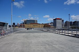
 View of Pipitea from the Fran Wilde Walk | |
 | |
| Coordinates: 41°16′28″S 174°47′01″E / 41.274466°S 174.783599°E | |
| Country | New Zealand |
| City | Wellington City |
| Local authority | Wellington City Council |
| Electoral ward |
|
| Area | |
| • Land | 138 ha (341 acres) |
| Population (2018)[1] | |
| • Total | 465 |
| Wadestown | Kaiwharawhara | |
| Thorndon |
|
(Wellington Harbour) |
| Wellington Central |
Pipitea is a central suburb of Wellington, in the Wellington region of New Zealand's North Island.
Geography[edit]
The new suburb of Pipitea was created and its boundaries were fixed at a meeting of the full Wellington City Council on 20 August 2003. After that time suburb changes must receive the further consent of the New Zealand Geographic Board.
- the territory
- the sites of Pipitea Pā and Old St Paul's on the inland side of Thorndon Quay,
- the reclaimed land east and south of Thorndon Quay and Hutt Road from along the shoreline from Kaiwharawhara to Whitmore Street,
- the Government Centre bounded by Kate Sheppard Place (formerly Sydney Street East), Hill Street, Sydney Street West, Bowen Street and the reclaimed land.
Demographics[edit]
Pipitea[edit]
Pipitea, comprising the statistical areas of 7021731, 7021520, 7021521, 7021522, 7021523 (which has no permanent residents) and 7021524, covers 1.38 km2 (0.53 sq mi).[2]
| Year | Pop. | ±% p.a. |
|---|---|---|
| 2006 | 444 | — |
| 2013 | 483 | +1.21% |
| 2018 | 465 | −0.76% |
| Source: [1] | ||
Pipitea had a population of 465 at the 2018 New Zealand census, a decrease of 18 people (−3.7%) since the 2013 census, and an increase of 21 people (4.7%) since the 2006 census. There were 225 households, comprising 240 males and 225 females, giving a sex ratio of 1.07 males per female, with 30 people (6.5%) aged under 15 years, 141 (30.3%) aged 15 to 29, 249 (53.5%) aged 30 to 64, and 42 (9.0%) aged 65 or older.
Ethnicities were 78.1% European/Pākehā, 9.0% Māori, 2.6% Pasifika, 16.8% Asian, and 2.6% other ethnicities. People may identify with more than one ethnicity.

Although some people chose not to answer the census's question about religious affiliation, 52.3% had no religion, 32.9% were Christian, 5.2% were Hindu, 1.3% were Muslim, 1.9% were Buddhist and 3.2% had other religions.
Of those at least 15 years old, 210 (48.3%) people had a bachelor's or higher degree, and 9 (2.1%) people had no formal qualifications. 204 people (46.9%) earned over $70,000 compared to 17.2% nationally. The employment status of those at least 15 was that 321 (73.8%) people were employed full-time, 39 (9.0%) were part-time, and 12 (2.8%) were unemployed.[1]
| Name | Population | Households | Median age | Median income |
|---|---|---|---|---|
| 7021731 | 66 | 33 | 37.1 years | $58,100 |
| 7021520 | 162 | 81 | 32.2 years | $53,400 |
| 7021521 | 54 | 21 | 35.2 years | $80,600 |
| 7021522 | 54 | 24 | 31.3 years | $65,700 |
| 7021524 | 129 | 66 | 41.8 years | $72,700 |
| New Zealand | 37.4 years | $31,800 |
Pipitea-Kaiwharawhara[edit]
Pipitea-Kaiwharawhara statistical area also includes the largely industrial suburb of Kaiwharawhara and covers 2.22 km2 (0.86 sq mi).[2] It had an estimated population of 1,150 as of June 2023,[3] with a population density of 518 people per km2.

| Year | Pop. | ±% p.a. |
|---|---|---|
| 2006 | 597 | — |
| 2013 | 849 | +5.16% |
| 2018 | 960 | +2.49% |
| Source: [4] | ||
Pipitea-Kaiwharawhara had a population of 960 at the 2018 New Zealand census, an increase of 111 people (13.1%) since the 2013 census, and an increase of 363 people (60.8%) since the 2006 census. There were 387 households, comprising 474 males and 486 females, giving a sex ratio of 0.98 males per female. The median age was 32.5 years (compared with 37.4 years nationally), with 78 people (8.1%) aged under 15 years, 354 (36.9%) aged 15 to 29, 444 (46.2%) aged 30 to 64, and 81 (8.4%) aged 65 or older.
Ethnicities were 77.8% European/Pākehā, 10.0% Māori, 2.5% Pasifika, 17.2% Asian, and 4.1% other ethnicities. People may identify with more than one ethnicity.
The percentage of people born overseas was 34.4, compared with 27.1% nationally.
Although some people chose not to answer the census's question about religious affiliation, 54.7% had no religion, 30.3% were Christian, 0.3% had Māori religious beliefs, 5.0% were Hindu, 0.6% were Muslim, 0.9% were Buddhist and 2.8% had other religions.
Of those at least 15 years old, 390 (44.2%) people had a bachelor's or higher degree, and 30 (3.4%) people had no formal qualifications. The median income was $52,400, compared with $31,800 nationally. 351 people (39.8%) earned over $70,000 compared to 17.2% nationally. The employment status of those at least 15 was that 558 (63.3%) people were employed full-time, 138 (15.6%) were part-time, and 39 (4.4%) were unemployed.[4]
Economy[edit]
Retail[edit]
The Capital Gateway Centre shopping precinct has 13 stores, including Freedom Furniture.[5]
References[edit]
- ^ a b c "Statistical area 1 dataset for 2018 Census". Statistics New Zealand. March 2020. 7021731, 7021520, 7021521, 7021522 and 7021524.
- ^ a b "ArcGIS Web Application". statsnz.maps.arcgis.com. Retrieved 23 January 2024.
- ^ "Population estimate tables - NZ.Stat". Statistics New Zealand. Retrieved 25 October 2023.
- ^ a b "Statistical area 1 dataset for 2018 Census". Statistics New Zealand. March 2020. Pipitea-Kaiwharawhara (250700). 2018 Census place summary: Pipitea-Kaiwharawhara
- ^ "Location – Capital Gateway". capitalgatewayretail.co.nz. Capital Gateway.
