
Mica Mountain (British Columbia)
| Mica Mountain | |
|---|---|
 North aspect | |
| Highest point | |
| Elevation | 2,855 m (9,367 ft)[1] |
| Prominence | 361 m (1,184 ft)[1] |
| Listing | Mountains of British Columbia |
| Coordinates | 52°53′14″N 119°31′41″W / 52.88722°N 119.52806°W[2] |
| Naming | |
| Etymology | Mica |
| Geography | |
 Mica Mountain Location in British Columbia  Mica Mountain Mica Mountain (Canada) | |
| Location | British Columbia, Canada |
| District | Cariboo Land District |
| Parent range | Cariboo Mountains Premier Range |
| Topo map | NTS 83D13 Kiwa Creek[2] |
Mica Mountain is a 2,855-meter-elevation (9,367-foot) mountain summit located in British Columbia, Canada.
Description[edit]
Mica Mountain is situated 12 kilometers (7.5 miles) southwest of Tête Jaune Cache, British Columbia, at the eastern edge of the Premier Range which is a subset of the Cariboo Mountains. The Southern Yellowhead Highway passes the eastern base of the mountain as it traverses Robson Valley. Precipitation runoff from Mica Mountain drains into Tête Creek and the McLennan River. Topographic relief is significant as the summit rises over 1,650 meters (5,400 feet) above the creek in four kilometers (2.5 miles). In good weather the view from the summit includes Mount Robson, Canoe Mountain and Kinbasket Lake. The mountain's well-established local name was officially adopted 23 May 1962 by the Geographical Names Board of Canada.[3] The name refers to the mineral mica which was mined from the higher slopes of the peak in the early 1900s.[4]
Climate[edit]
Based on the Köppen climate classification, Mica Mountain is located in a subarctic climate zone with cold, snowy winters, and mild summers.[5] Temperatures in winter can drop below −20 °C with wind chill factors below −30 °C.
See also[edit]
Gallery[edit]
-
 Northeast aspect
 -
 Tête Jaune Cache from summit of Mica Mountain, with Mount Robson in background
 -
 Peaks of the Premier Range, looking south from the summit of Mica Mountain
 -
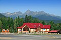 Mica Mountain (right) seen with Valemount Visitor Information Centre


References[edit]
- ^ a b "Mica Mountain". Bivouac.com. Retrieved 2022-09-16.
- ^ a b "Mica Mountain". Geographical Names Data Base. Natural Resources Canada. Retrieved 2022-09-16.
- ^ "Mica Mountain". BC Geographical Names. Retrieved 2022-09-16.
- ^ Canadian Mining Journal, Volume 35, (1914), Toronto, p. 357
- ^ Peel, M. C.; Finlayson, B. L.; McMahon, T. A. (2007). "Updated world map of the Köppen−Geiger climate classification". Hydrol. Earth Syst. Sci. 11: 1633–1644. ISSN 1027-5606.
External links[edit]
- Mica Mountain: weather forecast
- Mica Mountain Mine Trail: trailpeak.com