Lingunan
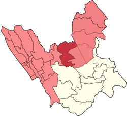
Lingunan is a landlocked 1st congressional district urban barangay in Valenzuela City, Philippines. It borders the barangays Viente Reales to the west, Canumay West to the east, Lawang Bato to the north-east and the city of Meycauayan which its barangays Lawa and Caingin borders it to the north. Based on the 2020 census, it has a population of 24,088.[1]
Lingunan | |
|---|---|
 Lingunan (red) with its first congressional co-barangays (light red) in Valenzuela | |
Lingunan (Luzon) | |
| Coordinates: 14°43′7″N 120°58′34″E / 14.71861°N 120.97611°E | |
| Government | |
| • Barangay Captain[2] | Jose Trinidad Cabral |
| • Sangguniang Kabataan Chairperson | Caryl Anne Ramos Race |
| Area | |
| • Total | 1.59 km2 (0.61 sq mi) |
| Elevation | 10 m (30 ft) |
| Highest elevation | 33 m (108 ft) |
| Lowest elevation | −3 m (−10 ft) |
| Population (2020)[1] | |
| • Total | 24,088 |
| • Density | 15,000/km2 (39,000/sq mi) |
| Time zone | UTC+8 (PST) |
| Postal code | 1446 |
| Area code | 02 |
History[edit]
During the Spanish and American occupation, the place was a thriving agricultural area.[4]
Geography[edit]
Lingunan is located about 14 kilometers north of Manila in the coordinates 14°43′7″N 120°58′34″E / 14.71861°N 120.97611°E.
It has an enclosed creek named Lingunan Creek, which in 2021 is the most improved estero by Department of Environment and Natural Resources (DENR) in Metro Manila.[5][6] Its surrounding rivers are found on its border with Bulacan and on its border with Barangay Viente Reales.
Climate[edit]
The Köppen-Geiger climate classification of Lingunan is Tropical Monsoon (Am) which has less pronounce dry seasons or extraordinary rainy wet seasons and pronounce dry seasons.[citation needed]
Population[edit]
| Year | Pop. | ±% |
|---|---|---|
| 1990 | 6,884 | — |
| 1995 | 12,040 | +74.9% |
| 2000 | 11,875 | −1.4% |
| 2007 | 14,661 | +23.5% |
| 2010 | 17,436 | +18.9% |
| 2015 | 21,217 | +21.7% |
| 2020 | 24,088 | +13.5% |
| Source: Philippine Statistics Authority[7][8][9][10][11][12][1] | ||
References[edit]
- ^ a b c "2020 Census of Population by City and Barangay". Philippine Statistics Authority. Retrieved 2024-03-28.
- ^ PIO, Administrator, Team. "Punong Barangay Directory". City Government of Valenzuela. Retrieved 2024-03-10.
{{cite web}}: CS1 maint: multiple names: authors list (link) - ^ "Carte topographique Lingunan, altitude, relief". Cartes topographiques (in French). Retrieved 2024-03-10.
- ^ PIO, Administrator, Team. "Lingunan". City Government of Valenzuela. Retrieved 2024-03-28.
{{cite web}}: CS1 maint: multiple names: authors list (link) - ^ Manila, RadyoMaN (2021-03-09). "Lingunan Creek sa Valenzuela City, itinanghal na most improved estero sa Metro Manila ng DENR sa katatapos na Gawad Taga-Ilog - RMN Networks". RMN Networks. Retrieved 2024-04-23.
- ^ PIO, Administrator, Team. "Valenzuela City". City Government of Valenzuela. Retrieved 2024-04-23.
{{cite web}}: CS1 maint: multiple names: authors list (link) - ^ "1990 Census of Population by City and Barangay" (PDF). Philippine Statistics Authority. Retrieved March 25, 2024.
- ^ "1995 Census of Population by City and Barangay" (PDF). Philippine Statistics Authority. Retrieved 2024-03-25.
- ^ "2000 Census of Population by City and Barangay" (PDF). Philippine Statistics Authority. Retrieved 2024-03-25.
- ^ Philippine Statistics Authority. "2007 Census of Population by City and Barangay". Scribd. Archived from the original on 2024-03-25. Retrieved 2024-03-25.
- ^ "2010 Census of Population in Philippines". Philippine Statistics Authority. Retrieved 2024-03-25.
- ^ "2015 Census of Population by City and Barangay" (PDF). Philippine Statistics Authority. Retrieved 2024-03-28.


