
Goodwood Road, Adelaide
Goodwood Road Fiveash Drive, Ayliffes Road | |
|---|---|
 | |
| The southern section of the Goodwood Subway in 2008 | |
| Coordinates | |
| General information | |
| Type | Road |
| Location | Adelaide |
| Length | 9.3 km (5.8 mi)[1] |
| Former route number | (Adelaide–Wayville) |
| Major junctions | |
| North end | West Terrace South Terrace Anzac Highway Adelaide |
| South end | South Road Main South Road St Marys, Adelaide |
| Location(s) | |
| Region | Eastern Adelaide, Southern Adelaide[2] |
Goodwood Road (and its southern sections as Fiveash Drive and Ayliffes Road) is a major north–south arterial road, approximately 10 kilometres long, in Adelaide, South Australia. It runs between the Adelaide city centre and Adelaide's southern suburbs of Pasadena and Panorama.[3]
Route[edit]
Goodwood starts at the intersection of Anzac Highway, West Terrace and South Terrace in the south-western corner of the Adelaide city centre. It heads south, through the southern Adelaide Parklands to meet with Greenhill Road. It continues south through Wayville, passing the Royal Adelaide Showgrounds. The traffic lights at Leader Street mark the boundary with the suburb of Goodwood, and the location of the Goodwood Park Hotel.
The road then crosses the Glenelg tram line and, although it retains 4 lanes, the speed limit is reduced to 50 km/h. The road narrows as it passes the Goodwood library, civic centre and shopping precinct which contains Capri Theatre, numerous restaurants, and Goodwood Primary School. Victoria Street marks the boundary with the suburb of Millswood. The road continues past the former Goodwood Orphanage through the so-called "Goodwood Subway", adjacent to Millswood railway station.
This is a deep road underpass which has double-lane traffic in both directions, and an elevated pedestrian walkway along the western wall. It was originally built for the Goodwood Road tram to pass safely under the Belair railway line and the main Adelaide-Melbourne Railway Line. Although the trams stopped travelling along Goodwood Road and the tracks were removed many decades ago, the subway continues to provide grade-separation between a very busy arterial road and a railway line with long, slow freight trains.
Past the subway, the road widens and the speed limit returns to 60 km/h again. It continues south through the suburbs of Kings Park, (east side and possibly Adelaide's smallest suburb), and Clarence Park (west side) to the intersection with Cross Road, a busy intersection now monitored by speed and red light cameras.
Passing through the suburbs of Cumberland Park (west side) and Westbourne Park (east side), the next major intersection is where Edward Street and Grange Road meet, and marks the start of Colonel Light Gardens (east side) and Daw Park (west side). Here the road widens considerably to 6 lanes and a dual carriageway separated by a wide central grassed nature strip containing many trees.
At the intersection of Springbank and Daws roads, although it retains 6 lanes and dual carriageway, the road narrows and its wide central nature strip is replaced by a narrow concrete curb. Located near this intersection are the Repatriation General Hospital, Daw Park, Springbank Secondary College, and Bedford Industries.
Goodwood Road continues south through Panorama for almost another kilometre, passing the Centennial Park Cemetery before turning south-west and changing name to Fiveash Drive. It heads through Pasadena for a short distance before turning west and changing name to Ayliffes Road. It passes Shepherds Hill Recreation Park before ending at the intersection of South Road and Shepherds Hill Road, and the Southern Expressway beyond.
Major intersections[edit]
| LGA[4] | Location[1][5] | km[1] | mi | Destinations | Notes |
|---|---|---|---|---|---|
| Adelaide | Adelaide | 0.0 | 0.0 | West Terrace (north) – Adelaide CBD South Terrace (east) – Adelaide CBD Anzac Highway (southwest) – Plympton, Glenelg | Northern terminus of Goodwood Road; no access from Anzac Highway to Goodwood Road |
| Adelaide–Unley boundary | Adelaide–Wayville boundary | 0.6 | 0.37 | ||
| Unley | Goodwood | 1.5 | 0.93 | Glenelg tram line | |
| Millswood–Kings Park boundary | 2.5 | 1.6 | Belair railway line | ||
| Unley–Mitcham boundary | Clarence Park–Kings Park–Cumberland Park–Westbourne Park quadripoint | 3.4 | 2.1 | ||
| Mitcham | Daw Park–Panorama boundary | 6.1 | 3.8 | Springbank Road (east) – Clapham | |
| Pasadena–Panorama boundary | 7.1 | 4.4 | Grandview Drive – Panorama | Name change: Goodwood Road (north), Fiveash Drive (southwest) | |
| 8.5 | 5.3 | Cashel Street (no access) | Name change: Fiveash Drive (northeast), Ayliffes Road (west) | ||
| Mitcham–Marion boundary | St Marys–Tonsley–Bedford Park tripoint | 9.3 | 5.8 | South-westbound entry and north-eastbound exit only | |
| South Road (north) – Edwardstown, Mile End, Hindmarsh Main South Road (southwest) – Reynella, Cape Jervis, Victor Harbor Shepherds Hill Road (south) – Blackwood | Southern terminus of Ayliffes Road | ||||
| |||||
-
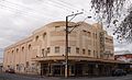 The Capri Cinema
 -
 The Goodwood Orphanage
 -
 Goodwood Subway and Belair Railway Line
 -
 Church of Christ, Colonel Light Gardens
 -
 Ayliffes Road bridge: The above ground road bridges were assembled on-site and moved into their final position using multi-wheeled lifters.


See also[edit]
References[edit]
- ^ a b c Google (1 July 2022). "Goodwood Road" (Map). Google Maps. Google. Retrieved 1 July 2022.
- ^ "Location SA Map viewer with regional layers". Government of South Australia. Retrieved 16 June 2022.
- ^ 2003 Adelaide Street Directory, 41st Edition. UBD (A Division of Universal Press Pty Ltd). 2003. ISBN 0-7319-1441-4.
- ^ "Location SA Map viewer with LGA layers". Government of South Australia. Retrieved 16 June 2022.
- ^ "Location SA Map viewer with suburb layers". Government of South Australia. Retrieved 16 June 2022.