
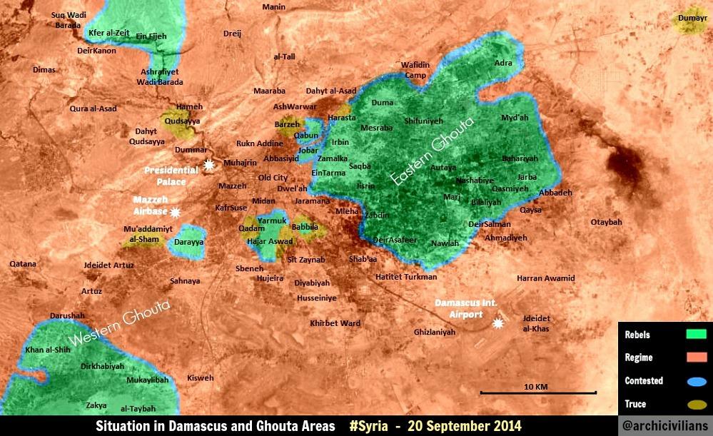
File talk:Rif Damashq.svg/Archive 1
| This is an archive of past discussions. Do not edit the contents of this page. If you wish to start a new discussion or revive an old one, please do so on the current talk page. |
| Archive 1 | Archive 2 |
Yarmouk
Yarmouk contested Ariskar (talk) 14:45, 3 March 2014 (UTC)
http://www.dailystar.com.lb/News/Middle-East/2014/Mar-03/249043-clashes-shatter-week-old-truce-in-syrias-yarmouk.ashx#axzz2vBRVGXpY Rogal Dorm (talk) 12:07, 6 March 2014 (UTC) Oussj (talk) 20:08, 6 March 2014 (UTC)
Changed. Kami888 (talk) 00:27, 7 March 2014 (UTC)
Yarmuk
Yarmuk should be marked as under a ceasefire again (violet). Ceasefire has been confirmed after an agreement was reached [1]. P.S. This source [2] says Jobar is government-held. Don't know if its correct. EkoGraf (talk) 11:43, 2 April 2014 (UTC)
Qudsaya
There was at one point truce in Qudsaya, but it seems that it may have been broken: [3]. Perhaps a small olive pocket there? ~~ Lothar von Richthofen (talk) 03:53, 15 March 2014 (UTC)
In Qudsaya the truce is not broken but there is a tense situation that brought to tightening control from SAA [4]. It is not contested, no fighting are ongoing. It must return to be violet.Paolowalter (talk) 23:42, 18 March 2014 (UTC)
I looked carefully and after some air attack around the 20th March no other fighting are reported. The most recent source is [5] (I do not how reliable) that states that the city is under siege but not under attack. I'd put back to violet. Paolowalter (talk) 10:29, 6 April 2014 (UTC)
Al Maliha
The city of Al Maliha should be marked as contested because in this city now are continuing clashes Syrian army vs rebels.sorcesource Hanibal911 (talk) 20:43, 3 April 2014 (UTC) The city of Al Maliha & Al Neshabieh should be marked as Red because SAA occupy these regions : http://english.farsnews.com/newstext.aspx?nn=13930115000268 — Preceding unsigned comment added by MZarif (talk • contribs) 14:20, 4 April 2014 (UTC)
- The SOHR said rebels and regime troops were fighting in the town of Mleiha in the Eastern Ghouta area.NOW News Hanibal911 (talk) 17:02, 5 April 2014 (UTC)
- There are claims from SyrPer that the city is under gov control, but no indipendent information.
Question: why the previous suggestions are not implemented in the map? Paolowalter (talk) 10:29, 6 April 2014 (UTC)
From [6] Al Maliha is at least partially under government control. ht rest is probably contested. Paolowalter (talk) 10:29, 6 April 2014 (UTC)
== This whole setup has proven wrong. Since the map change (from dots to small maps) nobody is updating the "Syrian_civil_war_detailed_map". Now it looks like nothing is happening in those cities (Aleppo, Daraa, Damascus...). It used to have several updates per day, now nobody is updating those maps for months. If that is what was intended you have done great job. You should revert it back to old system (with dots)... ==
Question: Would you please change the type pf map to Dots for ease of change? MZarif (talk) 12:17, 9 April 2014 (UTC)
- I agree. We can keep this template in the table below the map, but for the main map we need a format that allows for quick changes. The dots are easier to read and easier to change.213.204.101.17 (talk) 20:07, 9 April 2014 (UTC)
Question: When this map got change to Dot map?Where can we see the changes happen these days which caused by recent SAA Operations in Aleppo And Dameshq?MZarif (talk) 19:49, 10 April 2014 (UTC)
I completely disagree... A "dot map" is not clear at all. And what is the interest for the map to be easier to change if their is actually nothing to change. The front lines almost don't evolve at all for months.... It will be more than sufficient if the map is updated once in three months for exemple.Oussj (talk) 12:39, 18 April 2014 (UTC)
Barzeh
Barzeh under the control of the Syrian army this confirms a reliable source. Source said that the Mortar bombs struck the regime-held neighborhoods of Bab Touma, Tabbaleh and Barzeh, and the suburb of Jaramana, killing one person each in Tabbaleh and Jaramana, the Observatory added.The Daily Star Hanibal911 (talk) 06:50, 14 April 2014 (UTC)
- Are you sure you want to make that change? We know that Barzeh consists of several parts, some of which are definitely regime held, but in others we know there is a truce. There's a chance that neighborhoods with power-sharing arrangements will be referred to as "regime held" occasionally. Let's wait and see if other sources also treat it as such. Kami888 (talk) 22:02, 15 April 2014 (UTC)
From [7] Qudsaya is under truce, not contested. Please turn it violet. Paolowalter (talk) 21:48, 28 April 2014 (UTC)
- I can't read any of that but I'll take your word for it. I'll change it in the next update. Kami888 (talk) 04:19, 3 May 2014 (UTC)
Jobar
This needs verification if true, but pro-regime source shows Jobar surrounded and the road to its east as being controlled by regime. http://www.syrianperspective.com/2014/05/east-ghouta-offensive-updated-map.html — Preceding unsigned comment added by 169.231.65.41 (talk) 06:39, 8 May 2014 (UTC)
Qadam truce
It is reported that a truce was agreeed in al-Qadam. Please turn it into violet [8]. Paolowalter (talk) 15:43, 14 May 2014 (UTC)
Mliha
Mliha has been captured [9] by the Army. Change to red please. EkoGraf (talk) 20:44, 3 May 2014 (UTC)
Twitter is not sufficient in general as RS. Anyway there are also [10] ("On Saturday, Assad’s forces entered in the rural town of Mleeha near the capital, Damascus, state-run television and the Britain-based Syrian Observatory for Human Rights reported.") Also [11] and [12], even if they fall short of claiming the take over of the city by SAA.
SAA declared officially the control of the city [13]. Paolowalter (talk) 22:25, 3 May 2014 (UTC)
First, its the twitter account of the AL RAI Chief International Correspondent, who just yesterday had an interview with the BBC (so reliable). Second, if you would check the main civil war map, we have started using credible twitter reports for some time now (for months). Third, a non-twitter source [14] confirming full capture. EkoGraf (talk) 03:07, 4 May 2014 (UTC)
Here is another source confirming data the editor EkoGraf.source Hanibal911 (talk) 08:09, 4 May 2014 (UTC)
- Alright. I hope I won't have to change it back in a few days. Kami888 (talk) 03:27, 4 May 2014 (UTC)
Fighting ongoing in Mliha http://syriahr.com/en/index.php?option=com_news&nid=2214&Itemid=2&task=displaynews#.U2e4NPldWgY Sopher99 (talk) 16:13, 5 May 2014 (UTC)
- I thought everybody agreed SOHR was biased. There is a rebel flag right there on the homepage, why would you think this is an unbiased reliable source? Somebody please revert Sopher's changes. 213.204.103.19 (talk) 12:03, 7 May 2014 (UTC)
________
This is just a fanboy fb page https://www.facebook.com/syrianmilitary/posts/649919915089394 - And this is pro Insurgen Source http://syriahr.com/en/index.php?option=com_news&nid=2214&Itemid=2&task=displaynews
However according to this liveleak Items rebels are lying about their claims in Mliha
http://www.liveleak.com/view?i=0f7_1399375193
This Arabic news agency from Lebanon claim the Army controlled that full http://en.alalam.ir/news/1591635
This is the Syrian Official news agency there said now Army is disabling the explosive factories there but no specified if the 100% of the zone is captured http://sana.sy/ara/336/2014/05/06/542903.htm
The official video from SANA
https://www.youtube.com/watch?v=Mv-FdKXQI30
seems the whole of the place can be in Syrian Army control now. — Preceding unsigned comment added by LogFTW (talk • contribs) 05:11, 7 May 2014 (UTC)
Harasta should be green, there is no truce there and it is under rebel control! — Preceding unsigned comment added by 2A01:E34:ED63:FF70:9491:316A:9336:5175 (talk) 15:46, 7 May 2014 (UTC)
Harasta is officially in Truce but some times is broken — Preceding unsigned comment added by LogFTW (talk • contribs) 03:38, 19 May 2014 (UTC)
File is now a blurry JPG
Since the May 24 edit, the file is no longer a vector image and many of the place names are difficult to make out. Esn (talk) 04:07, 30 May 2014 (UTC)
Adra
The syrian perspective in its latest map about the eastern ghouta has shown that rebels fully control adra. http://i.imgur.com/vDEVw26.jpg Here is another pro-gov source (RT) confirming it (http://www.youtube.com/watch?v=v-Lkr3GOe1k). Tradediatalk 13:36, 30 May 2014 (UTC)
Wadi Barada & Al-Shih
Do these two areas have to be in this smaller map anymore? They are both located on the larger map - one just changed color to red on the larger map but still is green here.
The conflict has been localized for a long while now, maybe it's a good idea to crop this map a bit and get rid of the two western corners of the map as one has become Al-Zabadani front (which no longer is connect to this map) and the other is part of the Northern Golan Offensive that happened to spread east on one single road to barely reach the edge of this map. — Preceding unsigned comment added by 98.224.15.164 (talk) 08:40, 3 June 2014 (UTC)
- Not sure about Wadi Barada, I think it's just outside the boundaries of this map. Khan al Shih is still rebel controlled AFAIK. Also I don't know if others would agree about downsizing the map. Kami888 (talk) 05:37, 7 June 2014 (UTC)
Duma
By the recent activities of SAA in east Ghuta army carried out operations in Duma it seems to be consider this area as contested the news like this can be one of reasons: http://sana.sy/eng/337/2014/06/14/550097.htm "....Moreover, army units carried out operations in al-Shifounieh farms and Tal Kerdi in Douma, killing several non-Syrian terrorists, among them Abdul-Kader al-Rifai, a Jordanian, and the terrorists Jihad Mahrat and Muhannad Barghouth. ...."MZarif (talk) 15:37, 14 June 2014 (UTC)
"Kafar Batna and Jesrin "
both pro-opposition and pro-goverment sources declared heavy clashes and advance of army in "Kafar Batna" and "Jesrin " . but in the map it should change red at the western parts and "contested" in east of those areas . http://syriahr.com/index.php?option=com_news&nid=20158&Itemid=2&task=displaynews http://farsnews.com/newstext.php?nn=13930319000663 — Preceding unsigned comment added by 2.178.214.113 (talk) 07:18, 16 June 2014 (UTC)
- Both sources appear to be talking about an artillery exchange targeting insurgents in the area. Google translate gave me this:
- "in conjunction with the shelling by regime forces on the areas in Maliha and its surroundings, while two rockets landed, believed to be the type of land - land areas in farms town of Kafr Batna Balgoth East, also fell missile is believed to be of the type of land - land, fired by regime forces on the area in the City Duma".
- So no, no clashes there yet. Kami888 (talk) 23:38, 16 June 2014 (UTC)
Al-Meliha
SAA troops enter town of Al-meliha :http://en.alalam.ir/news/160711446.143.248.40 (talk) 11:31, 1 July 2014 (UTC)
Mayda
Violent clashes have taken place between the Islamic battalions and Jaysho Al Islam against ISIS fighters in the town of Mid’a in the Eastern Ghouta.SOHR Hanibal911 (talk) 15:21, 1 July 2014 (UTC)
- Uhh I'm not really sure what color to use for that, or how to mark that. What would you suggest? Kami888 (talk) 22:02, 2 July 2014 (UTC)
The SAA got control of Mayda'a after heavy bombardment of ISIS troops there http://www.syrianperspective.com/2014/07/syrian-army-liberates-maydaah-in-the-ghouta.htmlMZarif (talk) 05:54, 5 July 2014 (UTC)
The city of Maydaa under army control here confirmation from a reliable sourceMZarif (talk) 06:01, 7 July 2014 (UTC) http://pdf.reuters.com/pdfnews/pdfnews.asp?i=43059c3bf0e37541&u=2014_07_03_11_23_9b58f3cc8721423e9137ca9e2fa77d9f_PRIMARY.jpg
- Someone just made a weird update to the map based on I'm not sure what exactly, I don't see anything on the talk page about it. Should I update the current version or will someone revert it to how it used to be? Kami888 (talk) 15:41, 7 July 2014 (UTC)
- You must return the previous version and update it in accordance with the data on the talk page. Hanibal911 (talk) 18:26, 7 July 2014 (UTC)
- My version was an update for 27th of June, so this Maydaa changes should be added. I didn't know this talk page existed, shouldn't it be in Commons? --Joan301009 (talk) 19:47, 7 July 2014 (UTC)
- 1. What is the source for your edit? 2. No it shouldn't be in the Commons, and besides you haven't posed anything in Commons either. Kami888 (talk) 00:53, 8 July 2014 (UTC)
- If twitter is sufficient, [15] --Joan301009 (talk) 15:45, 8 July 2014 (UTC)
- Twitter is generally not sufficient (unless its from a reputable source), but also I'm pretty sure we don't just redraw the entire map based on someone's twitter post - that would be absurd. Finally, I think the source you specified is considered pro-rebel and thus another reason why it's not sufficient by itself. Kami888 (talk) 16:31, 8 July 2014 (UTC)
- If twitter is sufficient, [15] --Joan301009 (talk) 15:45, 8 July 2014 (UTC)
- 1. What is the source for your edit? 2. No it shouldn't be in the Commons, and besides you haven't posed anything in Commons either. Kami888 (talk) 00:53, 8 July 2014 (UTC)
- My version was an update for 27th of June, so this Maydaa changes should be added. I didn't know this talk page existed, shouldn't it be in Commons? --Joan301009 (talk) 19:47, 7 July 2014 (UTC)
- You must return the previous version and update it in accordance with the data on the talk page. Hanibal911 (talk) 18:26, 7 July 2014 (UTC)
- Map from reliable sources Reuters on 3 July , shows that the city Mayda'a is under the control of the army and the case is closed!source And stop using the pro opposition maps to show the rebel successes because it is broke the rule of editing. Hanibal911 (talk) 17:13, 8 July 2014 (UTC)
- Ok
 --Joan301009 (talk) 18:07, 8 July 2014 (UTC)
- Ok
For what it's worth, I agree with Alhnuty that http://pdf.reuters.com/pdfnews/pdfnews.asp?i=43059c3bf0e37541&u=2014_07_03_11_23_9b58f3cc8721423e9137ca9e2fa77d9f_PRIMARY.jpg is a really shitty map which probably shouldn't be used for anything. Kami888 (talk) 19:23, 9 July 2014 (UTC)
But is a "Neutral" source anyway (West media is considered as pro Insurgent sources because the west is who backed some insurgents factions)
You have something to link ?
If you have nothing at the moment we have = Source 1 Source 2
Both sources Reuters ans Syrian Perspective coincide 100% --Pototo1 (talk) 17:43, 17 July 2014 (UTC)
New changes to Rif Dameshqe
if you refer to Main Talk page of "Template:Syrian_civil_war_detailed_map" sources added for Al maliha and other zones which caused major change i this map.MZarif (talk) 09:41, 14 August 2014 (UTC)
Maliha and east Ghouta
Following the new of the advance of SAA in Maliha (e.g. [16] and many, many other sources) the map shoudl be updated. Furthermore SOHR [17] reports fighting in Wadi Ayn Terma. That means SAA has advanced up to this city. The city is already contested but the read area should estend to its southern boundary. Furthermore there are report that SAA is positioned just on Zebdeen outskirts [18]. Please update the map.Paolowalter (talk) 10:20, 14 August 2014 (UTC)
SAA has taken full control of Maliha [19], rebels still putting up resistance in its northern outskirts. Please put the town red and its northern outskirts contested. EkoGraf (talk) 12:25, 14 August 2014 (UTC)
Town secured by the SAA fully [20]. EkoGraf (talk) 13:36, 15 August 2014 (UTC)
Do the editors of this map fighting with each other to change al-maliha situation !!!!!!!!!????????????MZarif (talk) 13:37, 16 August 2014 (UTC)
Al-Ghadam
Please change the "Al-Ghadam" zone to red because of the agreement signed between oppositions and SAA.MZarif (talk) 15:47, 20 August 2014 (UTC) Here is the source: http://www.syrianperspective.com/2014/08/damascus-al-qadam-liberated-at-last.html
It was also reminded in part of "آخرالاخبار"in WWW.Almayadeen.net — Preceding unsigned comment added by MZarif (talk • contribs) 14:04, 21 August 2014 (UTC) It's also confirmed by SOHR.
Htaitat al-Jarsh
Following http://www.almanar.com.lb/english/adetails.php?eid=169453&cid=23&fromval=1 Htaitat al-Jarsh (Hatita Al Jars in wikimapia) is taken by SAA. Update accordingly.Paolowalter (talk) 21:52, 5 September 2014 (UTC)
Same news from SOHR https://www.facebook.com/syriahroe/posts/579212688853740. Paolowalter (talk) 07:20, 6 September 2014 (UTC)
According to http://www.almasdarnews.com/article/syrian-army-liberates-strategic-areas-east-ghouta/ also the air base next to Zebdeen is taken by SAA http://wikimapia.org/#lang=it&lat=33.491482&lon=36.416888&z=16&m=b.
Mayda
From the discussion above in July Mayda is under SAA control. Please update.Paolowalter (talk) 19:02, 6 September 2014 (UTC)
don't even try this again,it it was agreed that it will stay that.Alhanuty (talk) 03:07, 7 September 2014 (UTC)
- He has a source [Reuters], so it has to change. — Preceding unsigned comment added by 2602:30A:C01B:89F0:4C1F:A767:8E14:8CED (talk) 19:17, 7 September 2014 (UTC)
Jobar, Zamaika and Daraya
I have updated some regions near Jobar and Zamaika (sources: 1 2 3) and Daraya (source: 4) because they haven't been updated for a long time. Also, in the northwest it seems that there aren't rebels (source: 5)--Joan301009 (talk) 11:04, 8 September 2014 (UTC)
The new map http://edge.liveleak.com/80281E/ll_a_s/2014/Sep/8/LiveLeak-dot-com-5ed_1410204624-BxBvY85CcAAv9p2_1410204778.jpg?d5e8cc8eccfb6039332f41f6249e92b06c91b4db65f5e99818bdd6964f45dfd4ae82&ec_rate=230 represents the most up to date situation and corresponds the situation on the ground at best of our knowledge. It should be reproduced closely. Paolowalter (talk) 21:48, 8 September 2014 (UTC)
- The nortwest region (Wadi Barada) should stay green. There is no evidence of change of status.
From https://twitter.com/Isham_AlAssad/status/509145609023275008 appears that fighters are still inside. Probably there is a de facto truce, because figthing are reported very rarely. Nevertheless it is likely not under government control.Paolowalter (talk) 21:01, 9 September 2014 (UTC)
Tadamon and Falesteen camp
Tadamon and Falesteen camp are marked as contested. As to Tadamon I have seen occasional attaks on it from SAA. So it is likely that there is a small rebel controlled area. As to Falesteen camp, I have never seen anything, probably it has the same status of Yarmouk, a truce in some sense. I guess it should be corrected. Paolowalter (talk) 21:14, 9 September 2014 (UTC)
Northeastern Jobar
A part of the northeastern section of Jobar known as the Taiba area has been confirmed by both sides to be SAA-held. Government source [21] and for the opposition source google FALL OF JOBAR 'WOULD SET US BACK TWO YEARS' (can not link it here because syria direct is black-listed by Wikipedia). So that sliver needs to be red. EkoGraf (talk) 18:40, 20 September 2014 (UTC)
- Why is Syria Direct banned? Is it an unacceptable source? Kami888 (talk) 03:14, 21 September 2014 (UTC)
Abbadeh
According data from pro opposition map the village Abbadeh under control by Syrian troops.here Hanibal911 (talk) 14:23, 20 September 2014 (UTC)
- Actually from the map the railway should be the front line, as suggested in the past.
On the other hand, Hajar Aswad in not on truce but green surrounded. And the region NW should be green as used to be. The changes were unjustified.Paolowalter (talk) 20:25, 20 September 2014 (UTC)
Al Marj area
This heavily pro-opposition site reports that Hezbollah and Iraqi militias are positioned in Al-Marj area in Eastern Ghouta: alarabiya 2014/08/15 alarabiya 2014/08/14
So I suggest at least making the Marj-El-Sultan Area contested or government controlled. ChrissCh94 (talk) 23:57, 16 August 2014 (UTC) ChrissCh94
- You are wrong. "Al-Marj area" is different from "Marj-El-Sultan". Look at the map in the videos. The "Al-Marj area" they are talking about is depicted west of Meliha, whereas "Marj-El-Sultan" is east of it. Tradediatalk 01:18, 24 September 2014 (UTC)
Adra
Adra labors housing under government control as of 25 September 2014 — Preceding unsigned comment added by Krypto1988 (talk • contribs) 07:50, 25 September 2014 (UTC)
This area should be marked as contested area SOHR and Pro government sources confirm this.151.238.164.121 (talk) 16:37, 21 September 2014 (UTC)
The latest map of Adra from pro-gov source https://twitter.com/PetoLucem/status/514453108999876608/photo/1. This map matches approximately the known status and should be used to edit the Damascus map, on the basis of the author's record of reliability.Paolowalter (talk) 19:49, 23 September 2014 (UTC)
al Blaleyyi
From SOHR https://www.facebook.com/syriahroe/posts/587269444714731 al Blaleyyi is contested. Map should be updated.Paolowalter (talk) 19:46, 24 September 2014 (UTC)
- It is the city Al Bilaliyah which is located north of the city Deir Salman. Hanibal911 (talk) 20:17, 24 September 2014 (UTC)
SAA captures Adra industrial zone
Pro-opposition source confirmed the SAA has captured the Adra industrial zone [22]. Change on Damascus map needed. EkoGraf (talk) 22:45, 24 September 2014 (UTC)
- Here another confirmation from pro opposition source that Adra al-ummaliyah under control by army.source Hanibal911 (talk) 07:52, 25 September 2014 (UTC)
- The Syrian army has taken full control of Adra al-ummaliyah.Al Jazeera Hanibal911 (talk) 10:21, 25 September 2014 (UTC)
- Can you please show on wikimapia where it is located? Thank you. Kami888 (talk) 10:41, 25 September 2014 (UTC)
- Syrian government troops recaptured the key rebel-held town of Adra northeast of the capital Damascus. But however, Adra's small Old City remained under rebel control.The Daily Star The whole area of the city of Adra under army control except the small part because area of Old City of Adra which still under rebel control. Hanibal911 (talk) 11:31, 25 September 2014 (UTC)
- When you look at the wikimapia Kami there is the large Adra Industrial area to the east which is already marked as SAA-held. The rebels control what is marked simply as Adra. That is composed of: industrial area to the west, industrial area to the north with New Adra, farm clearing in the center and Adra West/East district to the east. I believe Old Adra, which is still rebel-held, refers to Adra West/East district. EkoGraf (talk) 11:42, 25 September 2014 (UTC)
- Hmm it looks like on our map, both Adra al Omaliya and the north Adra industrial area are both already shown as government controlled. And that's the only areas which are reported as taken. As it seems that the actual Adra old city is still under rebel control, in that case no changes are necessary to the map since it was previously incorrect. Kami888 (talk) 18:18, 26 September 2014 (UTC)
- When you look at the wikimapia Kami there is the large Adra Industrial area to the east which is already marked as SAA-held. The rebels control what is marked simply as Adra. That is composed of: industrial area to the west, industrial area to the north with New Adra, farm clearing in the center and Adra West/East district to the east. I believe Old Adra, which is still rebel-held, refers to Adra West/East district. EkoGraf (talk) 11:42, 25 September 2014 (UTC)
- Syrian government troops recaptured the key rebel-held town of Adra northeast of the capital Damascus. But however, Adra's small Old City remained under rebel control.The Daily Star The whole area of the city of Adra under army control except the small part because area of Old City of Adra which still under rebel control. Hanibal911 (talk) 11:31, 25 September 2014 (UTC)
- Can you please show on wikimapia where it is located? Thank you. Kami888 (talk) 10:41, 25 September 2014 (UTC)
- The Syrian army has taken full control of Adra al-ummaliyah.Al Jazeera Hanibal911 (talk) 10:21, 25 September 2014 (UTC)
- But pto opposition source today said that the Syrian regime’s military forces took control of the city of Adra in the Damascus suburbs. And not said that rebels still present inside the city.here Hanibal911 (talk) 08:57, 26 September 2014 (UTC)
- This confirmed the reliable source.Naharnet Hanibal911 (talk) 09:03, 26 September 2014 (UTC)
- Syrian government troops recaptured the key town of Adra northeast of the capital Damascus.The Daily Star Hanibal911 (talk) 11:56, 26 September 2014 (UTC)
- This confirmed the reliable source.Naharnet Hanibal911 (talk) 09:03, 26 September 2014 (UTC)
Updated Adraa and Jobar too https://twitter.com/PetoLucem/status/513035203799818241/photo/1 you are using old map now https://twitter.com/PetoLucem/status/507207133772128256/photo/1 --Pototo1 (talk) 04:00, 26 September 2014 (UTC)
- SOHR today reported that the regime army took control over wide areas in Adra al Balad Area after two days of its control over the Labor City of Adra.source So now the whole town of Adra under army control. Hanibal911 (talk) 11:36, 27 September 2014 (UTC)
What is missing is:
- - al Blaleyyi contested
- - NW area in Wadi Barada valley green (it use to be so, it was changed without reason)
- - Hajar Aswad green (who ever stated there is a truce?)
- - Falestine camp is probably on truce like Yarmouk (neve heard of any clash)
- - Green are in Jobar reduced according to https://twitter.com/PetoLucem/status/513035203799818241 and make the brown areas around Jobat west of the highway red
- - Adra is now almost completely red (see discussion above)
Paolowalter (talk) 14:42, 27 September 2014 (UTC)
See new Adra map https://twitter.com/PetoLucem/status/515899183807873025/photo/1. It should be followed to change this map. It incorporates all the changes reported in the last days: Adra Omalya, Adra al Balad, Tel Kurds etc.Paolowalter (talk) 17:03, 27 September 2014 (UTC)
you exagerated too much the green Insurgent presence under right corner
I think you exaggerated too much the green Insurgent presence under right corner compared with previously maps — Preceding unsigned comment added by 190.203.192.159 (talk) 00:09, 28 September 2014 (UTC)
Western Ghouta
can you add the towns of Dirkhabiyah, Zakyah, Mukaylibah, Al-Taybah as rebel-held on the rif dimashq map it has been agreed on by editors. Alhanuty (talk) 06:19, 23 September 2014 (UTC)
- Where has it been agreed / on what basis? Kami888 (talk) 10:40, 25 September 2014 (UTC)
- It was discussed above some days ago in Kafr Shams section. In the last days many suggestions of corrections of the map have shown up in this takl area as well as in that of the Damascus map. Could you please tkae care of all of it?Paolowalter (talk) 15:16, 25 September 2014 (UTC)
- Near the town of Khan ash-Shih located the military base 137th Regiment which now under control by army this also confirmed pro opposition map here But on the map the area is marked completely under control by rebels so that you can correct this mistake on the map. Hanibal911 (talk) 06:47, 28 September 2014 (UTC)
Dukhaniyya
Pro-opposition source said that the Syrian army retake Dukhaniyya district.archicivilians Hanibal911 (talk) 06:18, 28 September 2014 (UTC)
- SOHR also reported that the regime forces recaptured al Dokhaneyyi area located on the outskirts of the capital Damascus and which is adjacent to Wadi Ayn Terma and the city of Jaramana.source Hanibal911 (talk) 08:59, 28 September 2014 (UTC)
SAA advances towards Duma
Kurdish journalist reporting SAA has captured Al-Suwan and are fighting for Tal-al-Kurdy as they advance towards Duma. Source [23]. EkoGraf (talk) 12:36, 29 September 2014 (UTC)
- Pro-government source [24] also reporting Al-Suwan (Tal al-Sawwan) captured. Location somewhere here [25]. EkoGraf (talk) 14:07, 29 September 2014 (UTC)
Harasta
From a pro-opp site syriadirect .org/rss/1592-syria-direct-news-update-10-1-14 Harasta is considered as government controlled, not in truce. Often a truce becomes gov control after some time.Paolowalter (talk) 16:16, 1 October 2014 (UTC)
New east Ghouta map
There is a new map of the situation in East Ghouta from Petolucem https://twitter.com/PetoLucem/status/517390682093547520Paolowalter (talk) 19:38, 1 October 2014 (UTC)
Dukhaniya
And saa captures full of dukhaniya area. source: http://www.syriahr.com/index.php?option=com_news&nid=24553&Itemid=2&task=displaynews#.Paolowalter (talk) 20:29, 6 October 2014 (UTC)
Al-Rayhan
Al-Rayhan under SAA control according to PetoLucem https://twitter.com/PetoLucem/status/519987076205666304 http://www.almasdarnews.com/article/syrian-republican-guard-liberate-al-rayhan-liberation-jobar-coming/ — Preceding unsigned comment added by 95.148.175.194 (talk) 21:01, 10 October 2014 (UTC)
Confirmed by the beloved SOHR: https://www.facebook.com/syriahroe/posts/595214543920221?comment_id=595215127253496¬if_t=like 2602:30A:C01B:89F0:4C1F:A767:8E14:8CED (talk) 23:46, 11 October 2014 (UTC)
Wadi Ein Terma
Comments on en.wikipedia.org/wiki/Talk:Cities_and_towns_during_the_Syrian_Civil_War#Wadi_Ayn_Termah show that the valley southe of Ein Terma is taken bby SAA. Update the map.Paolowalter (talk) 19:08, 11 October 2014 (UTC)
Also Confirmed by the "wonderful wizard" of SOHR: https://www.facebook.com/syriahroe/posts/595755190532823 2602:30A:C01B:89F0:4C1F:A767:8E14:8CED (talk) 16:34, 12 October 2014 (UTC)
SOHR has confirmed the SAA capture of Ein Terma valley [26]. Location here [27]. EkoGraf (talk) 03:40, 13 October 2014 (UTC)
Mayda
Mayda is under SAA control according to http://www.almasdarnews.com/article/syrian-army-captures-2-villages-east-ghouta/. Please update. Also Peto Lucem map confirms. Sohr says very little about this area, in any case almasdarnews is reliable.Paolowalter (talk) 20:30, 29 October 2014 (UTC)
Bala farms
SAA has captured the Bala farms, confirmed by new map from pro-opposition source [28]. EkoGraf (talk) 12:35, 9 November 2014 (UTC)
Der al-Asafir and Zabdin
Der al-Asafir and Zabdin are contested per pro-opposition SOHR [29]. Please make the correction. Thank you! EkoGraf (talk) 12:25, 10 November 2014 (UTC)
Government and rebel sources now also confirming Zabdin is contested [30][31] and possibly partly captured by the SAA. EkoGraf (talk) 15:59, 22 November 2014 (UTC)
- Pro opposition source Documents.sy reported that army captured town Zebdeen Hanibal911 (talk) 18:12, 22 November 2014 (UTC)
- SOHR reported that Syrian forces pull back from the Zabdin area.here Hanibal911 (talk) 15:16, 23 November 2014 (UTC)
- Should stay contested for now. EkoGraf (talk) 16:23, 23 November 2014 (UTC)
- Peto Lucem contradicts SOHR report: https://twitter.com/PetoLucem/status/536482765362200576 . This is never easy is it? XJ-0461 v2 (talk) 17:18, 23 November 2014 (UTC)
- Al-Masdar has also contradicted SOHR report http://www.almasdarnews.com/article/east-ghouta-battle-map-syrian-army-captures-zibdeen-tal-al-rayan/#prettyPhoto XJ-0461 v2 (talk) 19:09, 23 November 2014 (UTC)
- Should stay contested for now. EkoGraf (talk) 16:23, 23 November 2014 (UTC)
- SOHR reported that Syrian forces pull back from the Zabdin area.here Hanibal911 (talk) 15:16, 23 November 2014 (UTC)
al- Tayba
al- Tayba in the south west corner should be contested [32].79.45.138.153 (talk) 22:48, 27 November 2014 (UTC)
Wadi Barada
Referring to https://en.wikipedia.org/wiki/Talk:Cities_and_towns_during_the_Syrian_Civil_War#Wadi_Barada, the upper left corner part of the map should be green along the Barada Valley from 'Ayn al-Fijah to Al-Husayniyah , while Baseema should be contested.192.135.12.144 (talk) 11:37, 24 November 2014 (UTC)
Additional report from pro-opp site syriadirect org /rss/1706-syria-direct-news-update-11-26-14 that Ein al-Fijeh has been under encirclement and assault for days. That mean that Baseema, that is down stream along the valley, is likely to have been taken by SAA.79.45.138.153 (talk) 22:50, 27 November 2014 (UTC)
Darayya
The Army has captured Darayya per pro-opp Ara News: http://aranews.net/2014/12/pro-assad-forces-regain-areas-near-damascus/. Could Someone please change the map. Thanks. XJ-0461 v2 (talk) 21:04, 10 December 2014 (UTC)
Major World Newspapers and Sources like Al-Monitor and CNN and BBC and FOX would have then reported that,if it occurred,also authenic and authoritive source SOHR,refutes it,by stating further rebel advance,the map stays the same via http://syriahr.com/en/2014/12/3-fighters-at-least-killed-in-rif-dimashq-while-violent-clashes-erupts-in-ayn-al-dinar-region-in-homs/ .Alhanuty (talk) 01:25, 11 December 2014 (UTC)
- Your source is 1 day older than mine, so it is not a refutation. Also, it is just one neighborhood, do not expect any major news coverage. XJ-0461 v2 (talk) 02:37, 11 December 2014 (UTC)
NO,They would have reported,also this has a three year long stronghold,and SOHR which has been way more accurate,than Any Biased news outlet,like the biased Al-Masdar,reported rebel advance in it.Alhanuty (talk) 05:05, 11 December 2014 (UTC)
- Later, opposition Local Council of Darayya reported that the rebels reversed recent Syrian army gains in the city of Darayya.[www.syriadirect.org/rss/1740-syria-direct-news-update-12-10-14] So we have data only from pro-opposition sources so that let's find more data from more reliable sources. Also government source said that clashes still continue.Syria News Hanibal911 (talk) 08:05, 11 December 2014 (UTC)
- Do you realize how unintelligent you sound right now. I keep telling you that ANTI-ASSAD ARA NEWS reported that the SAA took Darayya, yet you continue to slam AL-MASDAR. Are you even reading at all? The report is a day newer than the SOHR report. If you want to worship SOHR, then do so by all means. But, we edit according to Wiki guild lines, and they say that news sources trump older ones. However, I am willing to wait for more reliable sources as Hanibal suggested, alright? XJ-0461 v2 (talk) 20:59, 11 December 2014 (UTC)
It was most likely a miss-quote by ARA. They probably ment the SAA captured some areas in Darayya, but hardly the whole town. Plus, there is the part where pro-government sources are reporting continuing fighting there. EkoGraf (talk) 06:03, 15 December 2014 (UTC) Some SAA advancement is claimed by pro-gov source [33] but fighitng is ongoing. Usually a full takeover of Darayy would get some coverage. Nothing on twitter except the quoted source.Paolowalter (talk) 13:25, 12 December 2014 (UTC)
Hosh Al Fara
I know that this is a pro-opposition source, but there is no source showing this town under SAA control DuckZz (talk) 01:14, 28 December 2014 (UTC)
- We cant use biased pro opposition source to display success of rebels. Need more reliable source. Hanibal911 (talk) 08:46, 28 December 2014 (UTC)
Per SOHR:https: //www.facebook.com/syriahroe/posts/603485269759815 XJ-0461 v2 (talk) 19:00, 19 January 2015 (UTC)
Irbeen
Apparently there is a truce in Irbeen [34]. Paolowalter (talk) 21:37, 20 January 2015 (UTC)
Douma
Reports on advance of SAA on northern Douma e.g.[35]. Some change on the map is appropriate.Paolowalter (talk) 07:33, 11 February 2015 (UTC)