
File:OVERVIEW, NORTHWEST SIDE, VIEW TO SOUTHEAST - Merrill Bridge, Spanning Milk River at Snake Creek-Merrill Road, Harlem, Blaine County, MT HAER MT-123-2.tif

Size of this JPG preview of this TIF file: 740 × 600 pixels. Other resolutions: 296 × 240 pixels | 592 × 480 pixels | 947 × 768 pixels | 1,263 × 1,024 pixels | 2,526 × 2,048 pixels | 5,225 × 4,236 pixels.
Original file (5,225 × 4,236 pixels, file size: 21.11 MB, MIME type: image/tiff)
| This is a file from the Wikimedia Commons. Information from its description page there is shown below. Commons is a freely licensed media file repository. You can help. |
Summary
| OVERVIEW, NORTHWEST SIDE, VIEW TO SOUTHEAST - Merrill Bridge, Spanning Milk River at Snake Creek-Merrill Road, Harlem, Blaine County, MT | ||||
|---|---|---|---|---|
| Photographer |
Hager, Kristi, creator |
|||
| Title |
OVERVIEW, NORTHWEST SIDE, VIEW TO SOUTHEAST - Merrill Bridge, Spanning Milk River at Snake Creek-Merrill Road, Harlem, Blaine County, MT |
|||
| Depicted place | Montana; Blaine County; Harlem | |||
| Date | 2005 | |||
| Dimensions | 4 x 5 in. | |||
| Current location |
Library of Congress Prints and Photographs Division Washington, D.C. 20540 USA http://hdl.loc.gov/loc.pnp/pp.print |
|||
| Accession number |
HAER MT-123-2 |
|||
| Credit line |
|
|||
| Source | https://www.loc.gov/pictures/item/mt0451.photos.198139p | |||
| Permission (Reusing this file) |
|
|||

File history
Click on a date/time to view the file as it appeared at that time.
| Date/Time | Thumbnail | Dimensions | User | Comment | |
|---|---|---|---|---|---|
| current | 20:24, 28 July 2014 | 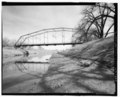 | 5,225 × 4,236 (21.11 MB) | Fæ | GWToolset: Creating mediafile for Fæ. HABS 24 July 2014 (2001:2300) |
File usage
The following pages on the English Wikipedia use this file (pages on other projects are not listed):