
File:Mahon Map.tif

Size of this JPG preview of this TIF file: 548 × 599 pixels. Other resolutions: 219 × 240 pixels | 439 × 480 pixels | 702 × 768 pixels | 936 × 1,024 pixels | 1,872 × 2,048 pixels | 3,199 × 3,499 pixels.
Original file (3,199 × 3,499 pixels, file size: 22.09 MB, MIME type: image/tiff)
| This is a file from the Wikimedia Commons. Information from its description page there is shown below. Commons is a freely licensed media file repository. You can help. |
Summary
| Plan of the city of New York : for the use of strangers
( |
||||||||||||||||||||||||
|---|---|---|---|---|---|---|---|---|---|---|---|---|---|---|---|---|---|---|---|---|---|---|---|---|
| Artist |
Chapin, William, 1802-1888 (Cartographer), S. Mahon (publisher) |
|||||||||||||||||||||||
| Title |
Plan of the city of New York : for the use of strangers |
|||||||||||||||||||||||
| Date |
Published: 1831. Coverage: Lower Manhattan, New York City. Digital item published 2005. |
|||||||||||||||||||||||
| Dimensions | 35 x 32 cm. | |||||||||||||||||||||||
| Collection |
|
|||||||||||||||||||||||
| Current location |
Lionel Pincus and Princess Firyal Map Division / Shelf locator: Map Div. 01-1778 |
|||||||||||||||||||||||
| Accession number |
|
|||||||||||||||||||||||
| Notes |
|
|||||||||||||||||||||||
| Source |
|
|||||||||||||||||||||||

|
This is a faithful photographic reproduction of a two-dimensional, public domain work of art. The work of art itself is in the public domain for the following reason:
The official position taken by the Wikimedia Foundation is that "faithful reproductions of two-dimensional public domain works of art are public domain".
This photographic reproduction is therefore also considered to be in the public domain in the United States. In other jurisdictions, re-use of this content may be restricted; see Reuse of PD-Art photographs for details. | ||||
File history
Click on a date/time to view the file as it appeared at that time.
| Date/Time | Thumbnail | Dimensions | User | Comment | |
|---|---|---|---|---|---|
| current | 04:31, 6 June 2021 |  | 3,199 × 3,499 (22.09 MB) | Beyond My Ken | Crop out border |
| 04:26, 6 June 2021 | 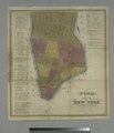 | 3,761 × 4,382 (47.16 MB) | Beyond My Ken | {{NYPL-image-full |Creator = Chapin, William, 1802-1888 (Cartographer), S. Mahon (publisher) |ImageTitle = Plan of the city of New York : for the use of strangers |Description = |Medium = |SpecificMaterialType = |dimensions = 35 x 32 cm. |ItemPagePlate = |Location = Lionel Pincus and Princess Firyal Map Division / Shelf locator: Map Div. 01-1778 |CreatedDate = |PublishedDate = 1831 |DepictedDate = |Coverage = Lower Manhattan, New York City |SourceImprint = |DigitalItemPublis... |
File usage
The following pages on the English Wikipedia use this file (pages on other projects are not listed):