
File:Draft of Major Matthews map of Vancouver's indigenous place names.tif

Size of this JPG preview of this TIF file: 800 × 566 pixels. Other resolutions: 320 × 227 pixels | 640 × 453 pixels | 1,024 × 725 pixels | 1,280 × 906 pixels | 2,560 × 1,812 pixels | 8,453 × 5,984 pixels.
Original file (8,453 × 5,984 pixels, file size: 94.86 MB, MIME type: image/tiff)
| This is a file from the Wikimedia Commons. Information from its description page there is shown below. Commons is a freely licensed media file repository. You can help. |
Summary
| Description |
English: This is a draft sketch by J._S._Matthews in 1932 (as noted on the sketch) for a plate that was eventually published in a book of Vancouver history. Provided by the City of Vancouver Public archives here. |
| Date | |
| Source | City of Vancouver Public Archives |
| Author | S. Matthews, City of Vancouver Archivist |
Licensing
| This work has been released into the public domain by its author, City of Vancouver. This applies worldwide. In some countries this may not be legally possible; if so: City of Vancouver grants anyone the right to use this work for any purpose, without any conditions, unless such conditions are required by law.
|
Public-domain status asserted on the Vancouver Archive site.

|
This media file is uncategorized.
Please help improve this media file by adding it to one or more categories, so it may be associated with related media files (how?), and so that it can be more easily found.
Please notify the uploader with {{subst:Please link images|File:Draft of Major Matthews map of Vancouver's indigenous place names.tif}} ~~~~ |
File history
Click on a date/time to view the file as it appeared at that time.
| Date/Time | Thumbnail | Dimensions | User | Comment | |
|---|---|---|---|---|---|
| current | 16:12, 29 July 2022 | 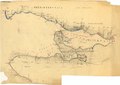 | 8,453 × 5,984 (94.86 MB) | TimBray | Uploaded a work by S. Matthews, City of Vancouver Archivist from City of Vancouver Public Archives with UploadWizard |
File usage
The following pages on the English Wikipedia use this file (pages on other projects are not listed):