
File:De Laet-Gerritsz Map.tif

Size of this JPG preview of this TIF file: 739 × 600 pixels. Other resolutions: 296 × 240 pixels | 592 × 480 pixels | 947 × 768 pixels | 1,262 × 1,024 pixels | 2,524 × 2,048 pixels | 4,457 × 3,616 pixels.
Original file (4,457 × 3,616 pixels, file size: 33.75 MB, MIME type: image/tiff)
| This is a file from the Wikimedia Commons. Information from its description page there is shown below. Commons is a freely licensed media file repository. You can help. |
Summary
| Description |
"Nova Anglia, Novum Belgium Et Virginia" ("New England, New Belgium and Virginia") |
|||||
| Date | between circa 1625 and circa 1630 | |||||
| Source | [1] and Cohen & Augustyn (1997) Manhattan in Maps: 1527 - 1995 p.27 | |||||
| Creator |
Hessel Gerritsz, published by Johannes de Laet in Die Nieuwe Werldt ofte Beschrijvinghe van West-Indien ("The New World or Description of the West Indies") (1630) |
|||||
| Permission (Reusing this file) |
|
|||||
| Georeferencing | If inappropriate please set warp_status = skip to hide. | |||||
File history
Click on a date/time to view the file as it appeared at that time.
| Date/Time | Thumbnail | Dimensions | User | Comment | |
|---|---|---|---|---|---|
| current | 23:45, 10 June 2021 | 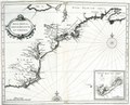 | 4,457 × 3,616 (33.75 MB) | Beyond My Ken | {{Information |Description="Nova Anglia, Novum Belgium Et Virginia" ("New England, New Belgium and Virginia") |Source=[https://sanderusmaps.com/our-catalogue/antique-maps/america/north-america/old-antique-map-of-new-england-virginia-by-j-de-laet-25385] and Cohen & Augustyn (1997) ''Manhattan in Maps: 1527 - 1995'' |Date=c.1625- 1630 |Author=Hessel Gerritsz, published by Johannes de Laet in ''Die Nieuwe Werldt ofte Beschrijvinghe van West-Indien'' ("The New World or Description of the West Ind... |
File usage
The following pages on the English Wikipedia use this file (pages on other projects are not listed):