
File:A plan of the city of New-York & its environs - to Greenwich, on the North or Hudsons River, and to Crown Point, on the East or Sound River, shewing the several streets, publick buildings, docks, fort NYPL433990.tiff

Size of this JPG preview of this TIF file: 492 × 599 pixels. Other resolutions: 197 × 240 pixels | 394 × 480 pixels | 631 × 768 pixels | 841 × 1,024 pixels | 1,682 × 2,048 pixels | 2,976 × 3,624 pixels.
Original file (2,976 × 3,624 pixels, file size: 25.18 MB, MIME type: image/tiff)
| This is a file from the Wikimedia Commons. Information from its description page there is shown below. Commons is a freely licensed media file repository. You can help. |
Summary
| Description | A plan of the city of New-York & its environs : to Greenwich, on the North or Hudsons River, and to Crown Point, on the East or Sound River, shewing the several streets, publick buildings, docks, fort & battery, with the true form & course of the commanding grounds, with and without the town : survey'd in the winter, 1775 [i.e. 1766] / John Montresor, engineer ; P. Andrews, sculp. | |||||||||||||||||||||||
| Notes | "To the Honble. Thos. Gage, Esqr., Major General and Commander in Chief of His Majesty's forces in North America, and Colonel of the 22d regiment of foot, this plan is most humbly inscribd by his obedient servant." Note 2.) Includes descriptive note, "References," and inset "A chart of the entrance to New York from Sandy Hook, shewing the properest channel for sailing, with ye banks and depths of water," ca. 1:128,000. Note 3.) Lawrence H. Slaughter Collection ; 840. Note 4.) National Endowment for the Humanities Grant for Access to Early Maps of the Middle Atlantic Seaboard. Note 5.) Oriented with north to upper right corner. Note 6.) Relief shown by hachures. Depths shown by soundings on inset. Note 7.) Described in Cohen's Manhattan in maps, 1527-1995, p. 72. | |||||||||||||||||||||||
| Standard reference | Stokes, I. N. P. Iconography of Manhattan Island, I, pl. 40, p. 339-340 | |||||||||||||||||||||||
| Physical description | 1 map : hand col. ; 63 x 52 cm. | |||||||||||||||||||||||
| Catalog Call Number | Map Div. 01-302 [Filed with NYC 1775] | |||||||||||||||||||||||
| Date | ||||||||||||||||||||||||
| Source |
http://digitalgallery.nypl.org/nypldigital/dgkeysearchdetail.cfm?imageID=433990
|
|||||||||||||||||||||||
| Author | Montrésor, John, 1736-1799 -- Engineer ;Andrews, Peter, fl. 1765-1782 -- EngraverDury, Andrew -- Publisher | |||||||||||||||||||||||
| Permission (Reusing this file) |
From The Lionel Pincus & Princess Firyal Map Division. Released on a CC0 license.[1] | |||||||||||||||||||||||
| Digital ID | 433990 | |||||||||||||||||||||||
| Location | Stephen A. Schwarzman Building / The Lionel Pincus and Princess Firyal Map Division | |||||||||||||||||||||||
| NYPL digital item published | 2-3-2004; updated 3-25-2011 | |||||||||||||||||||||||

Licensing
| This file is made available under the Creative Commons CC0 1.0 Universal Public Domain Dedication. | |
| The person who associated a work with this deed has dedicated the work to the public domain by waiving all of their rights to the work worldwide under copyright law, including all related and neighboring rights, to the extent allowed by law. You can copy, modify, distribute and perform the work, even for commercial purposes, all without asking permission.
|
The making of this file was supported by Wikimedia UK.
To see other files made with the support of Wikimedia UK, please see the category Supported by Wikimedia UK.
|
File history
Click on a date/time to view the file as it appeared at that time.
| Date/Time | Thumbnail | Dimensions | User | Comment | |
|---|---|---|---|---|---|
| current | 02:47, 11 June 2021 | 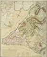 | 2,976 × 3,624 (25.18 MB) | Beyond My Ken | Crop out border, adjustments for visibility |
| 16:57, 9 April 2014 |  | 3,368 × 4,234 (40.81 MB) | Fæ | =={{int:filedesc}}== {{NYPL_map |digital_id = 433990 |creators = Montrésor, John, 1736-1799 -- Engineer ;Andrews, Peter, fl. 1765-1782 -- Engraver |record_id = 252843 |catalog_call_number = Map Div. 01-302 [Filed with NYC 1775] |item_physical_descrip... |
File usage
The following pages on the English Wikipedia use this file (pages on other projects are not listed):