
File:A chart of the southern hemisphere; shewing the tracks of some of the most distinguished navigators- by Captain James Cook, of His Majesty's navy. RMG F1972.tiff

Size of this JPG preview of this TIF file: 542 × 599 pixels. Other resolutions: 217 × 240 pixels | 434 × 480 pixels | 695 × 768 pixels | 927 × 1,024 pixels | 1,853 × 2,048 pixels | 5,653 × 6,247 pixels.
Original file (5,653 × 6,247 pixels, file size: 101.04 MB, MIME type: image/tiff)
| This is a file from the Wikimedia Commons. Information from its description page there is shown below. Commons is a freely licensed media file repository. You can help. |
Summary
| Author |
Captain James Cook; William Strahan and Thomas Cadell; William Whitchurch |
| Description |
English: A chart of the southern hemisphere; shewing the tracks of some of the most distinguished navigators: by Captain James Cook, of His Majesty's navy.Single sheet, engraving. Polar projection. The chart shows the tracks of Mendana in 1595, Quiros in 1606, Le Maire & Schouten in 1616, Tasman in 1642, Halley in 1700, Roggewein in 1722, Bouvet in 1738-39, Byron in 1765, Wallis in 1767, Bougainville in 1768, Surville in 1769, and Cook's first and second voyages. Tables in the corners contain the latitudes and longitudes of the islands lately discovered in the South Pacific Ocean, as they are laid down in this chart. Chart to show Cook's track and discoveries, plate 1 from the 2nd vol of his A Voyage Towards the South Pole. G201:3/1 (2) Southern Hemisphere by Cook |
| Date | 1777 |
| Dimensions | Printed area 56.5 x 54.5cm, on sheet 67 x 62cm. |
| Source/Photographer | http://collections.rmg.co.uk/collections/objects/540221 |
| Permission (Reusing this file) |
The original artefact or artwork has been assessed as public domain by age, and faithful reproductions of the two dimensional work are also public domain. No permission is required for reuse for any purpose. The text of this image record has been derived from the Royal Museums Greenwich catalogue and image metadata. Individual data and facts such as date, author and title are not copyrightable, but reuse of longer descriptive text from the catalogue may not be considered fair use. Reuse of the text must be attributed to the "National Maritime Museum, Greenwich, London" and a Creative Commons CC-BY-NC-SA-3.0 license may apply if not rewritten. Refer to Royal Museums Greenwich copyright. |
| Identifier | id number: G201:3/1(2) |
| Collection | Charts and maps |
Licensing
|
This is a faithful photographic reproduction of a two-dimensional, public domain work of art. The work of art itself is in the public domain for the following reason:
The official position taken by the Wikimedia Foundation is that "faithful reproductions of two-dimensional public domain works of art are public domain".
This photographic reproduction is therefore also considered to be in the public domain in the United States. In other jurisdictions, re-use of this content may be restricted; see Reuse of PD-Art photographs for details. | ||||
File history
Click on a date/time to view the file as it appeared at that time.
| Date/Time | Thumbnail | Dimensions | User | Comment | |
|---|---|---|---|---|---|
| current | 02:23, 27 August 2017 | 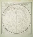 | 5,653 × 6,247 (101.04 MB) | Fæ | Royal Museums Greenwich Charts and maps, http://collections.rmg.co.uk/collections/objects/540221 |
File usage
The following pages on the English Wikipedia use this file (pages on other projects are not listed):