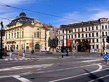
Ľudovít Štúr Square
 | |
| Type | Square |
|---|---|
| Location | Old Town, Bratislava |
| Coordinates | 48°08′25″N 17°06′36″E / 48.140243°N 17.109915°E |
Ľudovít Štúr Square is a square in the Old Town district of Bratislava.[1]
It is named after Ľudovít Štúr (1815 – 1856), a Slovak national awakener. Until 1918 it had the German and Hungarian names Krönungs-hügel-Platz and Koronázási Domb-tér,[2] meaning Coronation Hill Square. It is located near the Danube embankment, between Mostova Street, Rázus Embankment and Vajanského Embankment.
Among the important buildings are the headquarters of the Slovak Philharmonic Reduta, Esterházy Palace and Dežőfi Palace.
Transport connection[edit]
Gallery[edit]
-
Dezőfi Palace
References[edit]
- ^ "Námestie Ľudovíta Štúra, Bratislava - vyhľadávanie na mape". mapa.zoznam.sk (in Czech). Retrieved 2023-09-13.
- ^ Horváth, Vladimír. Bratislavský topografický lexikon. Tatran. ISBN 80-222-0229-0.
- ^ "Dopravný podnik Bratislava". dpb.sk. Retrieved 2023-09-13.
- ^ "Cestovné poriadky". imhd.sk Bratislava (in Slovak). Retrieved 2023-09-13.
- ^ "Cestovné poriadky autobusovej dopravy v Bratislavskom kraji". ARRIVA Bratislava (in Slovak). Retrieved 2023-09-13.
- ^ "Cestovné poriadky - IDS BK". www.idsbk.sk. Retrieved 2023-09-13.


