
Portal:Andes
The Andes Portal

The Andes (/ˈændiːz/ AN-deez), Andes Mountains or Andean Mountain Range (Spanish: Cordillera de los Andes; Quechua: Anti) are the longest continental mountain range in the world, forming a continuous highland along the western edge of South America. The range is 8,900 km (5,530 mi) long and 200 to 700 km (124 to 435 mi) wide (widest between 18°S and 20°S latitude) and has an average height of about 4,000 m (13,123 ft). The Andes extend from South to North through seven South American countries.: Argentina, Chile, Bolivia, Peru, Ecuador, Colombia and western Venezuela.
Along their length, the Andes are split into several ranges, separated by intermediate depressions. The Andes are the location of several high plateaus—some of which host major cities such as Quito, Bogotá, Cali, Arequipa, Medellín, Bucaramanga, Sucre, Mérida, El Alto and La Paz. The Altiplano Plateau is the world's second-highest after the Tibetan Plateau. These ranges are in turn grouped into three major divisions based on climate: the Tropical Andes, the Dry Andes, and the Wet Andes.
The Andes Mountains are the highest mountain range outside Asia. The range’s highest peak, Argentina's Aconcagua, rises to an elevation of about 6,961 m (22,838 ft) above sea level. The peak of Chimborazo in the Ecuadorian Andes is farther from the Earth's center than any other location on the Earth's surface, due to the equatorial bulge resulting from the Earth's rotation. The world's highest volcanoes are in the Andes, including Ojos del Salado on the Chile-Argentina border, which rises to 6,893 m (22,615 ft). (Full article...)
Selected articles
-

El Cocuy National Park is a national park located in the Andes Mountains within the nation of Colombia. Its official name is Parque Nacional Natural El Cocuy. (Full article...) -
Lake Mitococha or Mitucocha (possibly from Quechua mit'u, mitu mud, qucha lake, "mud lake") is a lake in Peru located in Huanuco Region, Lauricocha Province, Queropalca District. It has an elevation of 4,270 metres (14,009 ft) above sea level. It lies on the east side of the Huayhuash mountain range, northeast of Mituraju and Rondoy. Lake Mitococha is 0.83 km long and 0.3 km at its widest point. (Full article...) -

The Andean flicker (Colaptes rupicola) is a species of bird in subfamily Picinae of the woodpecker family Picidae. It is found in Argentina, Bolivia, Chile, Ecuador, and Peru. (Full article...) -
Chacaltaya (Mollo language for "bridge of winds" or "winds meeting point", Aymara for "cold road"[dubious ]) is a mountain in the Cordillera Real, one of the mountain ranges of the Cordillera Oriental, itself a range of the Bolivian Andes. Its elevation is 5,421 meters (17,785 ft). Chacaltaya's glacier — which was as old as 18,000 years — had an area of 0.22 km2 (0.085 sq mi) in 1940, which had been reduced to 0.01 km2 (0.0039 sq mi) in 2007 and was completely gone by 2009. Half of the meltdown, as measured by volume, took place before 1980. The final meltdown after 1980, due to missing precipitation and the warm phase of El Niño, resulted in the glacier's disappearance in 2009. The glacier was located about 30 kilometers (19 mi) from La Paz, near Huayna Potosí mountain. (Full article...) -

The guanaco (/ɡwɑːˈnɑːkoʊ/ ghwuah-NAH-koh; Lama guanicoe) is a camelid native to South America, closely related to the llama. Guanacos are one of two wild South American camelids; the other species is the vicuña, which lives at higher elevations. (Full article...) -
The Nevado del Quindío is an inactive volcano located in the Central Cordillera of the Andes in central Colombia. The summit marks the tripoint of the departments of Risaralda, Quindío and Tolima, and is also the highest point of the departments of Risaralda and Quindío. The mountain is one of the highest peaks in the Los Nevados National Natural Park, which is a wildlife sanctuary. There are no historical records of any eruption. The andesitic volcano is located on top of the Palestina Fault.
The snow fields and glaciers in the mountain are decreasing in a progressive way, about ten percent annually since the first scientific measures in the late 1980s, presumably because of global warming. (Full article...) -
Huandoy (probably from Quechua wantuy, to transfer, to transpose, to carry, to carry a heavy load) or Tullparaju (possibly from Quechua tullpa rustic cooking-fire, stove, rahu snow, ice, mountain with snow) is a mountain located inside Huascarán National Park in Ancash, Peru. It is the second-tallest peak of the Cordillera Blanca section of the Andes, after Huascarán. These two peaks are rather nearby, separated only by the Llanganuco glacial valley (which contains the Llanganuco Lakes) at 3,846 m asl.
It is a snow-capped mountain with four peaks arranged in the form of a fireplace, the tallest of which is 6,395 m. The four peaks are each over 6,000 m, and are:- Huandoy (6,395 m)
- Huandoy-West (6,356 m)
- Huandoy-South (6,160 m)
- Huandoy-East (6,000 m)
-
The Nevado del Tolima is a Late Pleistocene to recently active andesitic stratovolcano located in the Tolima department, Colombia. The volcano lies south of Nevado del Ruiz volcano and is situated within the Los Nevados National Natural Park. The volcano, whose most recent activity dates to 1943 and last major eruption around 3600 years ago, overlies the Eocene El Bosque Batholith, dated at 49.1 ± 1.7 Ma. (Full article...) -
Socompa is a large stratovolcano at the border of Argentina and Chile with an elevation of 6,051 metres (19,852 ft) metres. Part of the Chilean and Argentine Andean Volcanic Belt (AVB), it is within the Central Volcanic Zone, one of the various segments of the AVB. This part of the Andean volcanic belt begins in Peru and runs first through Bolivia and Chile, and then through Argentina and Chile, and contains about 44 active volcanoes. Socompa lies close to the pass of the same name, where the Salta-Antofagasta railway crosses the border.
Socompa is known for its large debris avalanche, which was formed 7,200 years ago when most of the northwestern slope collapsed and slid down, forming an extensive deposit. It was at first considered to be either a moraine or a nuee ardende deposit, until the 1980 eruption of Mount St. Helens prompted awareness of the instability of volcanic edifices and the existence of large scale collapses on them. The Socompa collapse is among the largest known with a volume of 19.2 cubic kilometres (4.6 cu mi) and covers a surface area of 490 square kilometres (190 sq mi), and its features are well preserved by the arid climate. Notable are the large toreva blocks which were left behind within the collapse crater. After the landslide, the volcano was rebuilt by the effusion of lava flows and much of the scar is now filled in. (Full article...) -
The hooded mountain tanager (Buthraupis montana) is a species of bird in the tanager family Thraupidae. It is the only member of the genus Buthraupis. This yellow, blue and black tanager is found in forest, woodland and shrub in the Andean highlands of Bolivia, Colombia, Ecuador, Peru, and Venezuela. At 23 centimetres (9.1 in) and 85 grams (3.0 oz), it is one of the largest tanagers (second in weight only to the white-capped tanager). (Full article...) -
Chumpe (possibly from Quechua chumpi: belt), Jatunriti, Ñanaloma or Yanaloma is a mountain in the Vilcanota mountain range in the Andes of Peru with 6,106 metres (20,033 ft) of elevation. It is located in the Cusco Region, Canchis Province, Pitumarca District as well as in the Quispicanchi Province, Ocongate District. Chumpe lies north of Lake Sibinacocha. (Full article...) -
Lanín is an ice-clad, cone-shaped stratovolcano on the border of Argentina and Chile. It forms part of two national parks: Lanín in Argentina and Villarrica in Chile. As a part of the flag and anthem of the Argentine province of Neuquén, it serves as a symbol for the region. Although the date of its last eruption is not known, it is estimated to have occurred within the last 10,000 years. Following the 1906 Valparaíso earthquake a local newspaper reported the volcano to have erupted, but a work published in 1917 by Karl Sapper disputed this.
The ascent is regulated by the management of Argentine National Parks and the Argentine National Gendarmerie and is technically relatively simple but has a much higher level of exposure than the neighbouring volcanoes. The nearest towns, usually employed as a base for climbers, are Pucón in Chile and Junín de los Andes in Argentina. (Full article...) -
Ritacuba Blanco is the highest peak of Cordillera Oriental, in the Andes Mountains of Colombia. It's also named Ritak'uwa, an ancient name from the U'wa indigenous people that live in the lowlands of the National Park Sierra Nevada del Cocuy y Güicán, where the Ritacuba Blanco is located.
The summit is accessible from the west via the town of El Cocuy, the village of Güicán, and the hamlet of Las Cabañas. The hike is fairly easy, but the weather is not reliable, and a glacier must be crossed.
Because of global warming, its glacier is melting at very high rates, backing down 25 linear mts per year; the same is happening at amazing speeds to all other snow-covered tropical mountains in Colombia. In 1950, Ritacuba Blanco's glacier extended down to 4,100 metres (13,500 ft) above sea level; in January 2007 its lowest point was at 4,500 metres (14,800 ft) above sea level. If this melting rate continues, the glacier is expected to disappear before 2055. (Full article...) -
Quilotoa (Spanish pronunciation: [kiloˈto.a]) is a water-filled crater lake and the most western volcano in the Ecuadorian Andes. The 3-kilometre (2 mi)-wide caldera was formed by the collapse of this dacite volcano following a catastrophic VEI-6 eruption about 800 years ago, which produced pyroclastic flows and lahars that reached the Pacific Ocean, and spread an airborne deposit of volcanic ash throughout the northern Andes. This last eruption followed a dormancy period of 14,000 years and is known as the 1280 Plinian eruption. The fourth (of seven) eruptive phase was phreatomagmatic, indicating that a Crater lake was already present at that time. The caldera has since accumulated a 250-metre-deep (820 ft) crater lake, which has a greenish color as a result of dissolved minerals. Fumaroles are found on the lake floor and hot springs occur on the eastern flank of the volcano.
Quilotoa is a site of growing popularity. The route to the "summit" (the small town of Quilotoa) is generally traveled by hired truck or bus from the town of Zumbahua 17 kilometres (11 mi) to the South, or more commonly by bus from Latacunga. Visitors have to pay two US dollars each to enter Quilotoa. There are a number of simple hostels in the immediate area offering services such as mules and guides. Activities include a four to five-hour hike around the caldera (whose diameter is just over 3 kilometres (2 mi)). The caldera rim is highly irregular and reaches its maximum elevations 3,810 metres (12,500 ft) to the N, 3,894 metres (12,776 ft) to the NW and 3,915 metres (12,844 ft) to the SE, at three lava domes. The 10-kilometre (6 mi) hike is sandy and steep in places and can be quite taxing, particularly if there is fog. (Full article...) -
Monte Pissis is an extinct volcano on the border of the La Rioja and Catamarca provinces in Argentina, 25 km (16 mi) to the east of the Chilean border and about 550 km (340 mi) north of Aconcagua. The mountain is the third-highest in the Western Hemisphere.
Monte Pissis is named after Pedro José Amadeo Pissis, a French geologist who worked for the Chilean government.
Due to its location in the Atacama Desert, the mountain has very dry conditions but features an extensive glacier, with crevasses, which is unique in the region. (Full article...) -
The Sierra Nevada del Cocuy Chita or Guican National Natural Park (or Sierra Nevada de Chita or Sierra Nevada de Güicán, Spanish: Parque Natural Sierra Nevada del Cocuy Chita o Guican is a national park and a series of highlands and glaciated peaks located within the Cordillera Oriental mountain range in the Andes Mountains of Colombia, at its easternmost point. It also corresponds to the highest range of the Eastern Cordillera and holds the biggest glacial mass in South America, north of the Equator. Since 1977, this region is protected within a National Natural Park (NNP-Cocuy) because of its fragile páramos, extraordinary bio-diversity and endemism, and its function as a corridor for migratory species under conditions of climate change. Among the Sierra’s natural attractions are the remaining 18 ice-covered peaks (there were as many as 25 in the recent past), glacial lakes and waterfalls. (Full article...) -
Cabaraya is a stratovolcano in Bolivia. It lies between the volcanoes Isluga and Tata Sabaya, immediately east of the border with Chile. (Full article...) -
Cerro Negro de Mayasquer is a volcano on the border of Colombia and Ecuador. It lies 3 kilometres (2 mi) north-west of the volcano Chiles, and the two peaks are considered part of the same Chiles-Cerro Negro volcanic complex. These volcanoes, together with Cumbal are andesitic in rock type. A 1936 eruption reported by the Colombian government agency INGEOMINAS may have been from the Ecuadorean volcano Reventador, otherwise the volcano has not erupted for around 160,000 years. (Full article...)
-
Sangay (also known as Macas, Sanagay, or Sangai) is an active stratovolcano in central Ecuador. It exhibits mostly strombolian activity. Geologically, Sangay marks the southern boundary of the Northern Volcanic Zone, and its position straddling two major pieces of crust accounts for its high level of activity. Sangay's approximately 500,000-year-old history is one of instability; two previous versions of the mountain were destroyed in massive flank collapses, evidence of which still litters its surroundings today.
Due to its remoteness, Sangay hosts a significant biological community with fauna such as the mountain tapir, giant otter, Andean cock-of-the-rock and king vulture. Since 1979, its ecological community has been protected as part of the Sangay National Park. Although climbing the mountain is hampered by its remoteness, poor weather conditions, river flooding, and the danger of falling ejecta, the volcano is regularly climbed, a feat first achieved by Robert T. Moore in 1929. (Full article...) -
The Cordillera Paine is a mountain group in Torres del Paine National Park in Chilean Patagonia. The cordillera is located 280 km (170 mi) north of Punta Arenas, and about 1,960 km (1,220 mi) south of the Chilean capital Santiago. It belongs to the Commune of Torres del Paine in Última Esperanza Province of Magallanes and Antártica Chilena Region. No accurate surveys have been published, and published elevations have been claimed to be seriously inflated, so most of the elevations given on this page are approximate. Paine means "blue" in the native Tehuelche (Aonikenk) language and is pronounced PIE-nay. (Full article...) -
Volcán Marmolejo is a 6,108 m (20,039 ft) high Pleistocene stratovolcano in the Andes on the border between Argentina and Chile. It is located 9 km (6 mi) NNE of the active San José volcano, and is the southernmost 6,000 m (19,685 ft)-plus peak in the world. The Argentine portion is within the Argentinean protection area of Provincial Reserve for Multiple Use and Natural Recreation Manzano / Portillo de Piuquenes. It is on the border of two provinces: Argentinean province of Mendoza and Chilean province of Cordillera. Its slopes are within the administrative boundaries of the two cities: Argentinean city of Tunuyán and the Chilean commune of San José de Maipo. (Full article...) -
Yerupajá is a mountain of the Huayhuash mountain range in west central Peru, part of the Andes. It is located at Áncash, Bolognesi Province, Lauricocha Province. At 6,635 metres (21,768 ft) (other sources: 6,617 m (21,709 ft)) it is the second-highest in Peru and the highest in the Huayhuash mountain range. The summit is the highest point in the Amazon River watershed, and was first reached in 1950 by Jim Maxwell and Dave Harrah, and its northern peak (Yerupajá Norte) in 1968 by the Wellingtonian Roger Bates and Graeme Dingle. Many visitors consider Yerupajá to be the most spectacular peak in South America.
There have been only a few successful ascents of the peak because it is one of the hardest Andean high peaks to climb. The most popular route is the southwest face. The approach is normally made from Huaraz southwards via Chiquián and Jahuacocha. (Full article...) -
Artesonraju is a pyramidal mountain peak located near the city of Caraz in the Cordillera Blanca mountain range in the Peruvian Andes. It is located at the Peruvian province of Huaylas and its slopes are within two cities: Santa Cruz and Caraz. Its summit has an elevation of 6,025 metres (19,767 ft) (or 5,999 metres (19,682 ft) according to the IGN-Peru map). It is one of many prominent peaks (2772 metres) located within the boundaries of Peru's Huascarán National Park.
Artesonraju has two distinguished climbing routes. Due to their difficulties, Artesonraju is seldom successfully climbed in comparison to other well known mountains in the Cordillera Blanca. This mountain is the inspiration for the current production logo for Paramount Pictures. (Full article...) -
Ancohuma or Janq'u Uma (Aymara janq'u white, uma water, "white water", also spelled Janq'uma, other spellings, Jankho Uma, Jankhouma) is the third highest mountain in Bolivia (after Sajama and Illimani). It is located in the northern section of the Cordillera Real, part of the Andes, east of Lake Titicaca. It lies just south of the slightly lower Illampu, near the town of Sorata.
Despite being higher than Illampu, Ancohuma is a gentler peak, with less local relief, and it is a somewhat easier climb. The peak was first climbed in 1919, by Rudolf Dienst and Adolf Schulze. Their route, still the easiest, climbs the southwest face, and is rated PD (not very difficult). Other routes exist on the northwest ridge and the west face. Depending on the route desired, the mountain is approached either from the west or from the northeast; each approach requires two to three days from Sorata. (Full article...) -
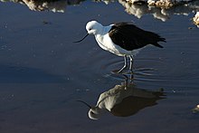
The Andean avocet (Recurvirostra andina) is a large wader in the avocet and stilt bird family, Recurvirostridae. It is resident in the Andes, breeding above 3500 m in northwestern Argentina, western Bolivia, northern Chile and southern Peru. (Full article...)


.png)

.jpg)

_Caldas.jpg)


Did you know...
- ... that the 1930s Polish Andean expeditions have been credited with several first ascents and the tracing of a new route to the summit of Aconcagua, the Andes' highest peak?
Need help?
Do you have a question about Andes that you can't find the answer to?
Consider asking it at the Wikipedia reference desk.
General images
-
 Simplified sketch of the present-situation along most of the Andes (from Andean orogeny)
 -
 Nevado del Huila, Colombia (from Andes)
 -
 Central Andes (from Andes)
 -
 Pacha Mama Ceremony (from Andean agriculture)
 -

-
 Bolivian Andes (from Andes)
 -

-

-
 Aerial view of Valle Carbajal in the Tierra del Fuego. The Andes range is about 200 km (124 mi) wide throughout its length, except in the Bolivian flexure where it is about 640 kilometres (398 mi) wide. (from Andes)
 -

-
 Frederic Edwin Church, Heart of the Andes, 1859. (from Andes)
 -
 Map of a north-south sea-parallel pattern of rock ages in western Colombia. This pattern is a result of the Andean orogeny. (from Andean orogeny)
 -

-
 Syncline next to Nordenskjöld Lake in Torres del Paine National Park. The syncline formed during the Andean orogeny. (from Andean orogeny)
 -
 View of Cuernos del Paine in Torres del Paine National Park, Chile (from Andes)
 -
 Parinacota, Bolivia/Chile (from Andes)
 -

-

-
 Peruvian farmers sowing maize and beans (from Andes)
 -

-
 A male Andean cock-of-the-rock, a species found in humid Andean forests and the national bird of Peru (from Andes)
 -
 The seaward tilting of the sedimentary strata of Salto del Fraile Formation in Peru was caused by the Andean orogeny. (from Andean orogeny)
 -
 Map of the Andean region of South America (from Andean agriculture)
 -

-
 Ulluco: Common crop of the Andean region (from Andean agriculture)
 -

-

-
 Pico Humboldt at sunset (from Andes)
 -
 Irrigating land in the Peruvian Andes (from Andes)
 -
 Paleogeography of the Late Cretaceous South America. Areas subject to the Andean orogeny are shown in light grey while the stable cratons are shown as grey squares. The sedimentary formations of Los Alamitos and La Colonia that formed in the Late Cretaceous are indicated. (from Andean orogeny)
 -
 Laguna de Sonso tropical dry forest in Northern Andes (from Andes)
 -
 Mashua tubers (from Andean agriculture)
 -
 Topographic map of the Andes by the NASA. The southern and northern ends of the Andes are not shown. The Bolivian Orocline is visible as a bend in the coastline and the Andes lower half of the map. (from Andean orogeny)

.jpg)


%E2%80%93Valle_Carbajal_01.jpg)
.jpg)


.jpg)


.jpg)


.JPG)

Subcategories

- Select [►] to view subcategories
Related portals
Subtopics
Associated Wikimedia
The following Wikimedia Foundation sister projects provide more on this subject:
-
 Commons
Free media repository -
 Wikibooks
Free textbooks and manuals -
 Wikidata
Free knowledge base -
 Wikinews
Free-content news -
 Wikiquote
Collection of quotations -
 Wikisource
Free-content library -
 Wikiversity
Free learning tools -
 Wiktionary
Dictionary and thesaurus


