The Blue Marble, a photograph of the planet Earth made on 7 December 1972 by the crew of the Apollo 17 spacecraft.
The world is the totality of entities, the whole of reality, or everything that exists. The nature of the world has been conceptualized differently in different fields. Some conceptions see the world as unique while others talk of a "plurality of worlds". Some treat the world as one simple object while others analyze the world as a complex made up of parts.
In scientific cosmology, the world or universe is commonly defined as "[t]he totality of all space and time; all that is, has been, and will be". Theories of modality talk of possible worlds as complete and consistent ways how things could have been. Phenomenology, starting from the horizon of co-given objects present in the periphery of every experience, defines the world as the biggest horizon or the "horizon of all horizons". In philosophy of mind, the world is contrasted with the mind as that which is represented by the mind. Theology conceptualizes the world in relation to God, for example, as God's creation, as identical to God or as the two being interdependent. In religions, there is a tendency to downgrade the material or sensory world in favor of a spiritual world to be sought through religious practice. A comprehensive representation of the world and our place in it, as is found in religions, is known as a worldview. Cosmogony is the field that studies the origin or creation of the world while eschatology refers to the science or doctrine of the last things or of the end of the world.
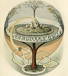
Yggdrasil, a modern attempt to reconstruct the Norse world tree which connects the heavens, the earth and the underworld The underworld, also known as the netherworld or hell, is the supernatural world of the dead in various religious traditions and myths, located below the world of the living. Chthonic is the technical adjective for things of the underworld.
The concept of an underworld is found in almost every civilization and "may be as old as humanity itself". Common features of underworld myths are accounts of living people making journeys to the underworld, often for some heroic purpose. Other myths reinforce traditions that the entrance of souls to the underworld requires a proper observation of ceremony, such as the ancient Greek story of the recently dead Patroclus haunting Achilles until his body could be properly buried for this purpose. People with high social status were dressed and equipped in order to better navigate the underworld. (Full article...)
Image 2
This article lists the world's busiest containerports (ports with container terminals that specialize in handling goods transported in intermodal shipping containers), by total number of twenty-foot equivalent units (TEUs) transported through the port. The table lists volume in thousands of TEU per year. The vast majority of containers moved by large, ocean-faring container ships are 20-foot (1 TEU) and 40-foot (2 TEU) ISO-standardshipping containers, with 40-foot units outnumbering 20-foot units to such an extent that the actual number of containers moved is between 55%–60% of the number of TEUs counted. (Full article...)
The World Series is the annual final championship series of Major League Baseball (MLB) in the United States and Canada. It has traditionally been held in October, though some more recent editions were contested in November due to expanded playoffs and/or season delays. It has been contested since 1903 between the champion teams of the American League (AL) and the National League (NL). The winner of the World Series championship is determined through a best-of-seven playoff, and the winning team is awarded the Commissioner's Trophy.
Prior to the AL and NL being split into divisions in 1969, the team with the best regular-season win–loss record in each league automatically clinched its league's pennant and advanced to the World Series, barring the rare tie necessitating a pennant playoff. Since then each league has conducted a League Championship Series (ALCS and NLCS) preceding the World Series to determine which teams will advance, while those series have been preceded in turn by Division Series (ALDS and NLDS) since 1995, and Wild Card games or series in each league since 2012. Until 2002, home-field advantage in the World Series alternated from year to year between the AL and NL. From 2003 to 2016, home-field advantage was given to the league that won that year's All-Star Game. Starting in 2017, home-field advantage was awarded to the league champion team with the better regular-season win–loss record, regardless of that team's seeding in earlier playoff rounds (i.e. a Wild Card team in one league will have home-field advantage over a division winner in the other league if the WC team had a better record or wins the tie-breaking procedure). (Full article...)
Image 4
Sustainability is a social goal for people to co-exist on Earth over a long time. Definitions of this term are disputed and have varied with literature, context, and time. Sustainability usually has three dimensions (or pillars): environmental, economic, and social. Many definitions emphasize the environmental dimension. This can include addressing key environmental problems, including climate change and biodiversity loss. The idea of sustainability can guide decisions at the global, national, and individual levels. A related concept is that of sustainable development, and the terms are often used to mean the same thing. UNESCO distinguishes the two like this: "Sustainability is often thought of as a long-term goal (i.e. a more sustainable world), while sustainable development refers to the many processes and pathways to achieve it."
Details around the economic dimension of sustainability are controversial. Scholars have discussed this under the concept of weak and strong sustainability. For example, there will always be tension between the ideas of "welfare and prosperity for all" and environmental conservation, so trade-offs are necessary. It would be desirable to find ways that separate economic growth from harming the environment. This means using fewer resources per unit of output even while growing the economy. This reduces the environmental impact of economic growth, such as pollution. Doing this is difficult. Some experts say there is no evidence that it is happening at the required scale. (Full article...)
Image 5
Global average temperatures show that the Medieval Warm Period was not a planet-wide phenomenon, and that the Little Ice Age was not a distinct planet-wide time period but rather the end of a long temperature decline that preceded recent global warming. The temperature record of the last 2,000 years is reconstructed using data from climate proxy records in conjunction with the modern instrumental temperature record which only covers the last 170 years at a global scale. Large-scale reconstructions covering part or all of the 1st millennium and 2nd millennium have shown that recent temperatures are exceptional: the Intergovernmental Panel on Climate ChangeFourth Assessment Report of 2007 concluded that "Average Northern Hemisphere temperatures during the second half of the 20th century were very likely higher than during any other 50-year period in the last 500 years and likely the highest in at least the past 1,300 years." The curve shown in graphs of these reconstructions is widely known as the hockey stick graph because of the sharp increase in temperatures during the last century. this broad pattern was supported by more than two dozen reconstructions, using various statistical methods and combinations of proxy records, with variations in how flat the pre-20th-century "shaft" appears. Sparseness of proxy records results in considerable uncertainty for earlier periods.
Individual proxy records, such as tree ring widths and densities used in dendroclimatology, are calibrated against the instrumental record for the period of overlap. Networks of such records are used to reconstruct past temperatures for regions: tree ring proxies have been used to reconstruct Northern Hemisphere extratropical temperatures (within the tropics trees do not form rings) but are confined to land areas and are scarce in the Southern Hemisphere which is largely ocean. Wider coverage is provided by multiproxy reconstructions, incorporating proxies such as lake sediments, ice cores and corals which are found in different regions, and using statistical methods to relate these sparser proxies to the greater numbers of tree ring records. The "Composite Plus Scaling" (CPS) method is widely used for large-scale multiproxy reconstructions of hemispheric or global average temperatures; this is complemented by Climate Field Reconstruction (CFR) methods which show how climate patterns have developed over large spatial areas, making the reconstruction useful for investigating natural variability and long-term oscillations as well as for comparisons with patterns produced by climate models. (Full article...)
Image 6
The earliest known world maps date to classical antiquity, the oldest examples of the 6th to 5th centuries BCE still based on the flat Earth paradigm. World maps assuming a spherical Earth first appear in the Hellenistic period. The developments of Greek geography during this time, notably by Eratosthenes and Posidonius culminated in the Roman era, with Ptolemy's world map (2nd century CE), which would remain authoritative throughout the Middle Ages. Since Ptolemy, knowledge of the approximate size of the Earth allowed cartographers to estimate the extent of their geographical knowledge, and to indicate parts of the planet known to exist but not yet explored as terra incognita.
With the Age of Discovery, during the 15th to 18th centuries, world maps became increasingly accurate; exploration of Antarctica, Australia, and the interior of Africa by western mapmakers was left to the 19th and early 20th century. (Full article...)
Image 7
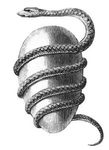
Jacob Bryant's Orphic Egg (1774)The cosmic egg, world egg or mundane egg is a mythologicalmotif found in the cosmogonies of many cultures and civilizations, including in Proto-Indo-European mythology. Typically, there is an egg which, upon "hatching", either gives rise to the universe itself or gives rise to a primordial being who, in turn, creates the universe. The egg is sometimes lain on the primordial waters of the Earth. Typically, the upper half of the egg, or its outer shell, becomes the heaven (firmament) and the lower half, or the inner yolk, becomes the Earth. The motif likely stems from simple elements of an egg, including its ability to offer nourishment and give rise to new life, as is reflected by the Latin proverbomne vivum ex ovo ('all life comes from an egg').
The following are images from various world-related articles on Wikipedia.
Image 1A reconstruction of human history based on fossil data. (from History of Earth)
Image 2An animation of the changing density of productive vegetation on land (low in brown; heavy in dark green) and phytoplankton at the ocean surface (low in purple; high in yellow) (from Earth)
Image 16Earth's history with time-spans of the eons to scale (from History of Earth)
Image 17Pangaea was a supercontinent that existed from about 300 to 180 Ma. The outlines of the modern continents and other landmasses are indicated on this map. (from History of Earth)
Image 18Artist's impression of a Hadean landscape with the relatively newly formed Moon still looming closely over Earth and both bodies sustaining strong volcanism. (from History of Earth)
Image 19An artist's impression of the Archean, the eon after Earth's formation, featuring round stromatolites, which are early oxygen-producing forms of life from billions of years ago. After the Late Heavy Bombardment, Earth's crust had cooled, its water-rich barren surface is marked by continents and volcanoes, with the Moon still orbiting Earth half as far as it is today, appearing 2.8 times larger and producing strong tides. (from Earth)
Image 29A view of Earth with its global ocean and cloud cover, which dominate Earth's surface and hydrosphere; at Earth's polar regions, its hydrosphere forms larger areas of ice cover. (from Earth)
Image 44Exaggerated illustration of Earth's elliptical orbit around the Sun, marking that the orbital extreme points (apoapsis and periapsis) are not the same as the four seasonal extreme points, the equinox and solstice (from Earth)
Image 47Earth's land use for human agriculture in 2019 (from Earth)
Image 48Trilobites first appeared during the Cambrian period and were among the most widespread and diverse groups of Paleozoic organisms. (from History of Earth)
Image 54A 2012 artistic impression of the early Solar System's protoplanetary disk from which Earth and other Solar System bodies were formed (from Earth)
Image 59The replicator in virtually all known life is deoxyribonucleic acid. DNA is far more complex than the original replicator and its replication systems are highly elaborate. (from History of Earth)
Image 60Earth's night-side upper atmosphere appearing from the bottom as bands of afterglow illuminating the troposphere in orange with silhouettes of clouds, and the stratosphere in white and blue. Next the mesosphere (pink area) extends to the orange and faintly green line of the lowest airglow, at about one hundred kilometers at the edge of space and the lower edge of the thermosphere (invisible). Continuing with green and red bands of aurorae stretching over several hundred kilometers. (from Earth)
Image 61Earth's western hemisphere showing topography relative to Earth's center instead of to mean sea level, as in common topographic maps (from Earth)
Image 65Shanghai. China urbanized rapidly in the 21st century.
Image 66Artist's impression of Earth during the later Archean, the largely cooled planetary crust and water-rich barren surface, marked by volcanoes and continents, features already roundmicrobialites. The Moon, still orbiting Earth much closer than today and still dominating Earth's sky, produced strong tides. (from History of Earth)
Image 76Geologic map of North America, color-coded by age. From most recent to oldest, age is indicated by yellow, green, blue, and red. The reds and pinks indicate rock from the Archean.
Image 77A map of heat flow from Earth's interior to the surface of Earth's crust, mostly along the oceanic ridges (from Earth)
Image 78Change in average surface air temperature and drivers for that change. Human activity has caused increased temperatures, with natural forces adding some variability. (from Earth)
Image 88Tiktaalik, a fish with limb-like fins and a predecessor of tetrapods. Reconstruction from fossils about 375 million years old. (from History of Earth)
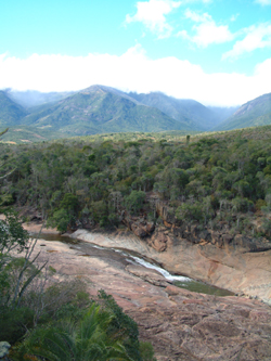
The state of Johor in Malaysia is noted for its national parks and forest reserves which preserve virgin rainforests known for its biodiversity and endangered species of animals. Mangrove swamps and coral reefs are also protected within these parks. (Full article...)
Image 3
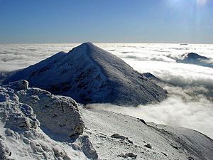
The mountain of Stob Binnein lies in the Loch Lomond and The Trossachs National Park. Many parts of Scotland are protected in accordance with a number of national and international designations because of their environmental, historical or cultural value. Protected areas can be divided according to the type of resource which each seeks to protect. NatureScot has various roles in the delivery of many environmental designations in Scotland, i.e. those aimed at protecting flora and fauna, scenic qualities and geological features. Historic Environment Scotland is responsible for designations that protect sites of historic and cultural importance. Some international designations, such as World Heritage Sites, can cover both categories of site.
The various designations overlap considerably with many protected areas being covered by multiple designations with different boundaries. (Full article...)
Andohahela National Park in southern Madagascar The national parks of Madagascar include all officially recognized protected areas as of 2015. The protected areas network of Madagascar is managed by the Madagascar National Parks Association (PNM-ANGAP). The network includes three types of protected areas: Strict Nature Reserves (IUCN category Ia), National Parks (IUCN category II) and Wildlife Reserves (IUCN category IV). At the 2003 IUCN World Parks Congress in Durban, the Malagasy President, Marc Ravalomanana, announced an initiative to more than triple the area under protection from approximately 17,000 km2 (6,600 sq mi) to over 60,000 km2 (23,000 sq mi) (from 3% to 10% of Madagascar's area). This "Durban Vision", as it has been dubbed, involved broadening the definition of protected areas in the country and legislation has been passed to allow the creation of four new categories of protected area: Natural Parks (IUCN category II), Natural Monuments (IUCN category III), Protected Landscapes (IUCN category V), and Natural Resource Reserves (IUCN category VI). As well as allowing these new objectives for protected areas management, the new legislation also provided for entities other than PNM-ANGAP to manage protected areas, such as government ministries, community associations, NGOs and other civil society organizations, and the private sector. (Full article...)
Image 13
Grand Canyon of Yellowstone The protected areas of the United States are managed by an array of different federal, state, tribal and local level authorities and receive widely varying levels of protection. Some areas are managed as wilderness, while others are operated with acceptable commercial exploitation. , the 42,826 protected areas covered 1,235,486 km2 (477,024 sq mi), or 13 percent of the land area of the United States. This is also one-tenth of the protected land area of the world. The U.S. also had a total of 871 National Marine Protected Areas, covering an additional 1,240,000 sq mi (3,200,000 km2), or 26 percent of the total marine area of the United States. (Full article...)
Protected areas of Indonesia comprise both terrestrial and marine environments in any of the six IUCN Protected Area categories. There are over 500 protected areas in Indonesia, of which 54 National Parks cover 16.4 million ha, and another 527 nature and game reserves cover a further 28.3 million ha. The total protected land area represents over 15% of Indonesia's landmass. Marine Protected Areas comprise over 15.7 million ha representing ca. 5% of territorial waters. (Full article...)
Image 6Only a few of the largest large igneous provinces appear (coloured dark purple) on this geological map, which depicts crustal geologic provinces as seen in seismic refraction data


.jpg)


 A reconstruction of human history based on fossil data. (from History of Earth)
 An animation of the changing density of productive vegetation on land (low in brown; heavy in dark green) and phytoplankton at the ocean surface (low in purple; high in yellow) (from Earth)
 Lithified stromatolites on the shores of Lake Thetis, Western Australia. Archean stromatolites are the first direct fossil traces of life on Earth. (from History of Earth)
 Artist's conception of Hadean Eon Earth, when it was much hotter and inhospitable to all forms of life. (from History of Earth)
 A banded iron formation from the 3.15 Ga Moodies Group, Barberton Greenstone Belt, South Africa. Red layers represent the times when oxygen was available; gray layers were formed in anoxic circumstances. (from History of Earth)
 Image of the physical world, captured by the Hubble Space Telescope (from World)
 Vitruvian Man by Leonardo da Vinci epitomizes the advances in art and science seen during the Renaissance. (from History of Earth)
 Benin Bronze head from Nigeria
 A 580 million year old fossil of Spriggina floundensi, an animal from the Ediacaran period. Such life forms could have been ancestors to the many new forms that originated in the Cambrian Explosion. (from History of Earth)


 Earth's history with time-spans of the eons to scale (from History of Earth)
 Pangaea was a supercontinent that existed from about 300 to 180 Ma. The outlines of the modern continents and other landmasses are indicated on this map. (from History of Earth)
 Artist's impression of a Hadean landscape with the relatively newly formed Moon still looming closely over Earth and both bodies sustaining strong volcanism. (from History of Earth)
 An artist's impression of the Archean, the eon after Earth's formation, featuring round stromatolites, which are early oxygen-producing forms of life from billions of years ago. After the Late Heavy Bombardment, Earth's crust had cooled, its water-rich barren surface is marked by continents and volcanoes, with the Moon still orbiting Earth half as far as it is today, appearing 2.8 times larger and producing strong tides. (from Earth)


 Obelisk of Axum, Ethiopia
 Angkor Wat temple complex, Cambodia, early 12th century
 Empires of the world in 1898
 Chloroplasts in the cells of a moss (from History of Earth)
 Machu Picchu, Inca Empire, Peru
 A view of Earth with different layers of its atmosphere visible: the troposphere with its clouds casting shadows, a band of stratospheric blue sky at the horizon, and a line of green airglow of the lower thermosphere around an altitude of 100 km, at the edge of space (from Earth)
 A view of Earth with its global ocean and cloud cover, which dominate Earth's surface and hydrosphere; at Earth's polar regions, its hydrosphere forms larger areas of ice cover. (from Earth)
 Tracy Caldwell Dyson, a NASA astronaut, observing Earth from the Cupola module at the International Space Station on 11 September 2010 (from Earth)
 Standing Buddha from Gandhara, 2nd century CE
 Pale orange dot, an artist's impression of Early Earth, featuring its tinted orange methane-rich early atmosphere (from Earth)
 Chennakesava Temple, Belur, India
 Earth's axial tilt causing different angles of seasonal illumination at different orbital positions around the Sun (from Earth)
 Notre-Dame de Paris, France
 Ming dynasty section, Great Wall of China
 An artist's impression of ice age Earth at glacial maximum. (from History of Earth)
 Dinosaurs were the dominant terrestrial vertebrates throughout most of the Mesozoic (from History of Earth)
 Ajloun Castle, Jordan
 An artist's rendering of a protoplanetary disk (from History of Earth)
 Olmec colossal head, now at the Museo de Antropología de Xalapa

 Graph showing range of estimated partial pressure of atmospheric oxygen through geologic time (from History of Earth)
 Earth's land use for human agriculture in 2019 (from Earth)
 Trilobites first appeared during the Cambrian period and were among the most widespread and diverse groups of Paleozoic organisms. (from History of Earth)
 Last Moon landing: Apollo 17 (1972)
 Artist's conception of Devonian flora (from History of Earth)
 Peopling of the world, the Southern Dispersal scenario
 Persepolis, Achaemenid Empire, 6th century BCE
 A 2012 artistic impression of the early Solar System's protoplanetary disk from which Earth and other Solar System bodies were formed (from Earth)
 A composite image of artificial light emissions at night on a map of Earth (from Earth)
 Florence, birthplace of the Italian Renaissance
 View of Earth from the Moon by the Lunar Reconnaissance Orbiter (from Earth)
 Great Mosque of Kairouan, Tunisia, founded 670 CE
 The replicator in virtually all known life is deoxyribonucleic acid. DNA is far more complex than the original replicator and its replication systems are highly elaborate. (from History of Earth)
 Earth's night-side upper atmosphere appearing from the bottom as bands of afterglow illuminating the troposphere in orange with silhouettes of clouds, and the stratosphere in white and blue. Next the mesosphere (pink area) extends to the orange and faintly green line of the lowest airglow, at about one hundred kilometers at the edge of space and the lower edge of the thermosphere (invisible). Continuing with green and red bands of aurorae stretching over several hundred kilometers. (from Earth)
 Earth's western hemisphere showing topography relative to Earth's center instead of to mean sea level, as in common topographic maps (from Earth)
 A pillar at Göbekli Tepe
 Artist's rendition of an oxinated fully-frozen Snowball Earth with no remaining liquid surface water. (from History of Earth)
 Great Pyramids of Giza, Egypt
 Shanghai. China urbanized rapidly in the 21st century.
 Satellite time lapse imagery of Earth's rotation showing axis tilt (from Earth)
 Taj Mahal, Mughal Empire, India
 Japanese depiction of a Portuguese carrack. European maritime innovations led to proto-globalization.
 A computer-generated image mapping the prevalence of artificial satellites and space debris around Earth in geosynchronous and low Earth orbit (from Earth)
 Yggdrasil, an attempt to reconstruct the Norse world tree which connects the heavens, the world, and the underworld. (from World)
 Geologic map of North America, color-coded by age. From most recent to oldest, age is indicated by yellow, green, blue, and red. The reds and pinks indicate rock from the Archean.
 A map of heat flow from Earth's interior to the surface of Earth's crust, mostly along the oceanic ridges (from Earth)
 Change in average surface air temperature and drivers for that change. Human activity has caused increased temperatures, with natural forces adding some variability. (from Earth)
 Cross-section through a liposome (from History of Earth)
 A schematic view of Earth's magnetosphere with solar wind flowing from left to right (from Earth)
 "Lucy", the first Australopithecus afarensis skeleton found, was only 1.06 m (3 ft 6 in) tall.
 A reconstruction of Pannotia (550 Ma). (from History of Earth)
 Artist's impression of the enormous collision that probably formed the Moon (from History of Earth)
 Battle during the 1281 Mongol invasion of Japan
 First airplane, the Wright Flyer, flew on 17 December 1903.
 A composite image of Earth, with its different types of surface discernible: Earth's surface dominating Ocean (blue), Africa with lush (green) to dry (brown) land and Earth's polar ice in the form of Antarctic sea ice (grey) covering the Antarctic or Southern Ocean and the Antarctic ice sheet (white) covering Antarctica. (from Earth)
 Fall of the Berlin Wall, 1989
 Tiktaalik, a fish with limb-like fins and a predecessor of tetrapods. Reconstruction from fossils about 375 million years old. (from History of Earth)


.jpg)


.jpeg)


.jpg)


.svg)


.jpg)


_(cropped).jpg)


 A plate tectonics map with volcano locations indicated with red circles
 The world map by Gerardus Mercator (1569), the first map in the well-known Mercator projection
 Time zones of the world
 1516 map of the world by Martin Waldseemüller
 United Nations Human Development Index map by country (2016)
 Only a few of the largest large igneous provinces appear (coloured dark purple) on this geological map, which depicts crustal geologic provinces as seen in seismic refraction data
 Mollweide projection of the world
 Index map from the International Map of the World (1:1,000,000 scale)
 The Goode homolosine projection is a pseudocylindrical, equal-area, composite map projection used for world maps.


 Commons
 Wikibooks
 Wikidata
 Wikinews
 Wikiquote
 Wikisource
 Wikispecies
 Wikiversity
 Wikivoyage
 Wiktionary


