
File:Turun kaupunkiseutu 2013.png

Size of this preview: 800 × 499 pixels. Other resolutions: 320 × 199 pixels | 640 × 399 pixels | 1,024 × 638 pixels | 1,301 × 811 pixels.
Original file (1,301 × 811 pixels, file size: 110 KB, MIME type: image/png)
| This is a file from the Wikimedia Commons. Information from its description page there is shown below. Commons is a freely licensed media file repository. You can help. |
| Description |
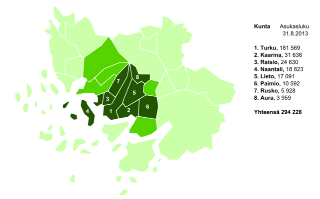
Turun kaupunkiseutu Turun kaupunkiseutu
Turun seutukunta
Varsinais-Suomi |
||
| Date | |||
| Source | Own work, information from 1, 2, 3 | ||
| Author | Derivative work: BishkekRocks (talk). SVG map of Finland is created by User:Care. Original bitmap map is created by User:Ningyou | ||
| Permission (Reusing this file) |
|
||
| Other versions |
File history
Click on a date/time to view the file as it appeared at that time.
| Date/Time | Thumbnail | Dimensions | User | Comment | |
|---|---|---|---|---|---|
| current | 17:26, 1 October 2013 | | 1,301 × 811 (110 KB) | Jontts | {{Information |Description=Turun kaupunkiseutu |Source=Own work, information from [http://www.varsinais-suomi.fi/index.php?option=com_content&view=article&id=218:turun-kaupunkiseudun-kaava-asiakirjat&catid=77 1], [http://www.tilastokeskus.fi/tup/kasit/... |
File usage
The following pages on the English Wikipedia use this file (pages on other projects are not listed):
Global file usage
The following other wikis use this file:
- Usage on fi.wikipedia.org