
File:Territorio libero di Trieste carta.png
Original file (511 × 804 pixels, file size: 104 KB, MIME type: image/png)
| This is a file from the Wikimedia Commons. Information from its description page there is shown below. Commons is a freely licensed media file repository. You can help. |
Summary
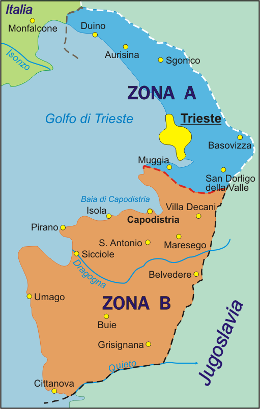
Map of the Free Territory of Trieste (1947-1954), with zone delimitation, in Italian. Own adaptation of http://sl.wikipedia.org/wiki/Slika:STO.png from the Slovene Wikipedia, by kind permission of the original author.
Carta del Territorio libero di Trieste (1947-1954), con delimitazione delle zone, versione italiana. Adattamento proprio di http://sl.wikipedia.org/wiki/Slika:STO.png dalla Wikipedia slovena, con permesso cortese del autore originario.
English version: Image:Free_Territory_of_Trieste_map.png German version: Image:Freies_Territorium_Triest_Karte.png
Licensing
| I, the copyright holder of this work, release this work into the public domain. This applies worldwide. In some countries this may not be legally possible; if so: I grant anyone the right to use this work for any purpose, without any conditions, unless such conditions are required by law. |

|
This historical map image could be re-created using vector graphics as an SVG file. This has several advantages; see Commons:Media for cleanup for more information. If an SVG form of this image is available, please upload it and afterwards replace this template with
{{vector version available|new image name}}.
It is recommended to name the SVG file “Territorio libero di Trieste carta.svg”—then the template Vector version available (or Vva) does not need the new image name parameter. |
File history
Click on a date/time to view the file as it appeared at that time.
| Date/Time | Thumbnail | Dimensions | User | Comment | |
|---|---|---|---|---|---|
| current | 17:04, 6 October 2005 | | 511 × 804 (104 KB) | Alib | Map of the Free Territory of Trieste (1947-1954), with zone delimitation, in Italian. Own adaptation of http://sl.wikipedia.org/wiki/Slika:STO.png from the Slovene Wikipedia, by kind permission of the original author. Carta del Territorio libero di Tries |
File usage
Global file usage
The following other wikis use this file:
- Usage on be.wikipedia.org
- Usage on br.wikipedia.org
- Usage on ca.wikipedia.org
- Usage on da.wikipedia.org
- Usage on et.wikipedia.org
- Usage on he.wikipedia.org
- Usage on it.wikipedia.org
- Usage on ka.wikipedia.org
- Usage on ko.wikipedia.org
- Usage on li.wikipedia.org
- Usage on lt.wikipedia.org
- Usage on no.wikipedia.org
- Usage on pl.wikipedia.org
- Usage on pt.wikipedia.org
- Usage on ru.wikipedia.org
- Usage on sc.wikipedia.org
- Usage on sh.wikipedia.org
- Usage on sl.wikipedia.org
- Usage on sr.wikipedia.org
- Usage on www.wikidata.org
- Usage on wuu.wikipedia.org