
File:NAMRIA map of Philippine maritime zones.png

Size of this preview: 581 × 600 pixels. Other resolutions: 232 × 240 pixels | 465 × 480 pixels | 644 × 665 pixels.
Original file (644 × 665 pixels, file size: 327 KB, MIME type: image/png)
| This is a file from the Wikimedia Commons. Information from its description page there is shown below. Commons is a freely licensed media file repository. You can help. |
Summary
| Description |
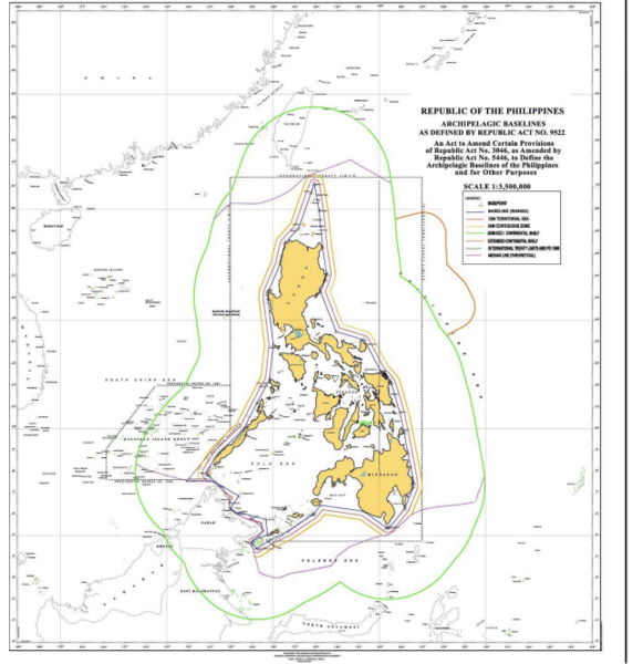
English: It is a map of Philippine maritime zones generated by the National Mapping and Resource Information Authority of the Philippines. |
| Date | |
| Source | https://ro.uow.edu.au/cgi/viewcontent.cgi?article=1773&context=lhapapers page 40. See also EndNote 2 there and see NAMRIA. |
| Author | National Mapping and Resource Information Authority of the Philippines |
Licensing
{
This work was first published in the Philippines and is now in the public domain because its copyright protection has expired by virtue of the Intellectual Property Code of the Philippines. The work meets one of the following criteria:
|
 |
File history
Click on a date/time to view the file as it appeared at that time.
| Date/Time | Thumbnail | Dimensions | User | Comment | |
|---|---|---|---|---|---|
| current | 03:34, 19 April 2024 | | 644 × 665 (327 KB) | Wtmitchell | Uploaded a work by National Mapping and Resource Information Authority of the Philippines from https://ro.uow.edu.au/cgi/viewcontent.cgi?article=1773&context=lhapapers page 40. See also EndNote 2 there and see NAMRIA. with UploadWizard |
File usage
The following pages on the English Wikipedia use this file (pages on other projects are not listed):