
File:Mapa de España - Constitución de 1873.svg

Size of this PNG preview of this SVG file: 416 × 349 pixels. Other resolutions: 286 × 240 pixels | 572 × 480 pixels | 916 × 768 pixels | 1,221 × 1,024 pixels | 2,441 × 2,048 pixels.
Original file (SVG file, nominally 416 × 349 pixels, file size: 1.44 MB)
| This is a file from the Wikimedia Commons. Information from its description page there is shown below. Commons is a freely licensed media file repository. You can help. |
Summary
| Description |
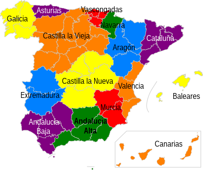
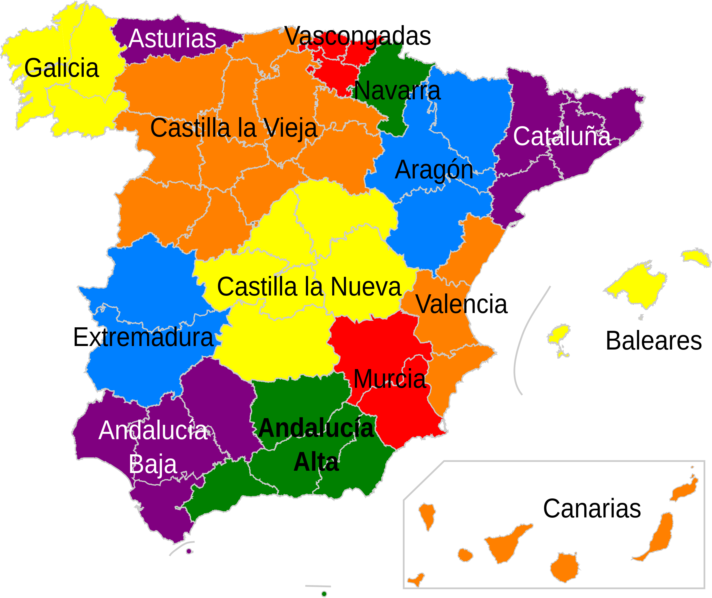
English: Map of Spain. Distribution and nomenclature of the Member States which would compose the Spanish Nation according to the Spanish Constitution draft made during the First Spanish Republic in 1873. Cuba and Puerto Rico are not represented. The provinces that contains each State are drawn arbitrarily by the author of the map, since the decision was a matter for the Member States.
Español: Mapa de España. Distribución y nomenclatura de los Estados miembros que habrían de componer la Nación Española según el proyecto de Constitución Española realizado durante la Primera República Española en 1873, que nunca se aprobó. No están representadas Cuba ni Puerto Rico. Distribución provincial orientativa, dado que su configuración era competencia de los Estados miembros.
El artículo primero de dicha Constitución dice: "Componen la Nación Española los Estados de Andalucía Alta, Andalucía Baja, Aragón, Asturias, Baleares, Canarias, Castilla la Nueva, Castilla la Vieja, Cataluña, Cuba, Extremadura, Galicia, Murcia, Navarra, Puerto Rico, Valencia, Regiones Vascongadas". |
| Date | |
| Source | Own work |
| Author | Jadelmo |
| Permission (Reusing this file) |
Mirar abajo. |
Licensing
I, the copyright holder of this work, hereby publish it under the following licenses:

|
Permission is granted to copy, distribute and/or modify this document under the terms of the GNU Free Documentation License, Version 1.2 or any later version published by the Free Software Foundation; with no Invariant Sections, no Front-Cover Texts, and no Back-Cover Texts. A copy of the license is included in the section entitled GNU Free Documentation License. |
This file is licensed under the Creative Commons Attribution-Share Alike Attribution-Share Alike 4.0 International, 3.0 Unported, 2.5 Generic, 2.0 Generic and 1.0 Generic license.
- You are free:
- to share – to copy, distribute and transmit the work
- to remix – to adapt the work
- Under the following conditions:
- attribution – You must give appropriate credit, provide a link to the license, and indicate if changes were made. You may do so in any reasonable manner, but not in any way that suggests the licensor endorses you or your use.
- share alike – If you remix, transform, or build upon the material, you must distribute your contributions under the same or compatible license as the original.
You may select the license of your choice.
File history
Click on a date/time to view the file as it appeared at that time.
| Date/Time | Thumbnail | Dimensions | User | Comment | |
|---|---|---|---|---|---|
| current | 14:54, 19 May 2010 | | 416 × 349 (1.44 MB) | Jadelmo | {{Information |Description={{en|1=Map of Spain. Distribution and nomenclature of the Member States which would compose the Spanish Nation according to the Spanish Constitution draft made during the First Spanish Republic in 1873. Cuba and Puerto Rico are |
File usage
The following pages on the English Wikipedia use this file (pages on other projects are not listed):
Global file usage
The following other wikis use this file:
- Usage on ar.wikipedia.org
- Usage on ca.wikipedia.org
- Usage on de.wikipedia.org
- Usage on es.wikipedia.org
- Usage on fr.wikipedia.org
- Usage on zh.wikipedia.org