
File:Adelsö - KMB - 16000300025798.jpg

Size of this preview: 800 × 532 pixels. Other resolutions: 320 × 213 pixels | 640 × 425 pixels | 1,024 × 681 pixels | 1,280 × 851 pixels | 2,560 × 1,702 pixels | 4,961 × 3,298 pixels.
Original file (4,961 × 3,298 pixels, file size: 2.06 MB, MIME type: image/jpeg)
| This is a file from the Wikimedia Commons. Information from its description page there is shown below. Commons is a freely licensed media file repository. You can help. |
| Adelsö
( |
|||||||||||||||||||||||||||
|---|---|---|---|---|---|---|---|---|---|---|---|---|---|---|---|---|---|---|---|---|---|---|---|---|---|---|---|
| Photographer |
|
||||||||||||||||||||||||||
| Title |
Adelsö |
||||||||||||||||||||||||||
| Original caption |
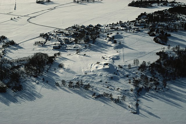
Notera Av dokumentationsskäl har originalbeskrivningen från Riksantikvarieämbetet behållits. Tillrättalägganden och alternativa beskrivningar bör införas separat från nedanstående information. Alsnö hus (RAÄ Adelsö 47:1), Hovgården och Adelsö kyrka.Felaktigheter kan även anmälas till denna sida. Motiv: Adelsö |
||||||||||||||||||||||||||
| Description |
Alsnö hus (RAÄ Adelsö 47:1), Hovgården och Adelsö kyrka.
|
||||||||||||||||||||||||||
| Depicted place | Sweden, Ekerö Municipality, Q10401127 | ||||||||||||||||||||||||||
| Date | Taken on 13 February 1986 | ||||||||||||||||||||||||||
| Collection |
|
||||||||||||||||||||||||||
| Accession number | |||||||||||||||||||||||||||
| Source |
Jan Norrman / Kulturmiljöbild, Riksantikvarieämbetet
|
||||||||||||||||||||||||||
| Permission (Reusing this file) |
This file is licensed under the Creative Commons Attribution 2.5 Generic license. Attribution: Jan Norrman / Riksantikvarieämbetet
|
||||||||||||||||||||||||||


| Object location | | View this and other nearby images on: OpenStreetMap |
|---|
File history
Click on a date/time to view the file as it appeared at that time.
| Date/Time | Thumbnail | Dimensions | User | Comment | |
|---|---|---|---|---|---|
| current | 11:33, 19 January 2022 | | 4,961 × 3,298 (2.06 MB) | VulpesVulpes42 | Högre upplösning. |
| 13:53, 11 July 2017 |  | 764 × 502 (344 KB) | AndreCostaWMSE-bot | {{Kulturmiljöbild-image | short title = Adelsö | original description = Alsnö hus (RAÄ Adelsö 47:1), Hovgården och Adelsö kyrka.<br> Motiv: Adelsö<br> Nyckelord: Flygbilder, Raä-Fastigheter, Riksintressen, Vintermotiv, Världsarv<br> Kategori:... |
File usage
The following pages on the English Wikipedia use this file (pages on other projects are not listed):
Global file usage
The following other wikis use this file:
- Usage on mk.wikipedia.org