
File:A map of North Carolina.jpg
Size of this preview: 800 × 425 pixels. Other resolutions: 320 × 170 pixels | 640 × 340 pixels | 1,024 × 544 pixels | 1,280 × 680 pixels | 2,560 × 1,360 pixels | 5,140 × 2,731 pixels.
Original file (5,140 × 2,731 pixels, file size: 1.33 MB, MIME type: image/jpeg)
| This is a file from the Wikimedia Commons. Information from its description page there is shown below. Commons is a freely licensed media file repository. You can help. |
Summary
| Description |
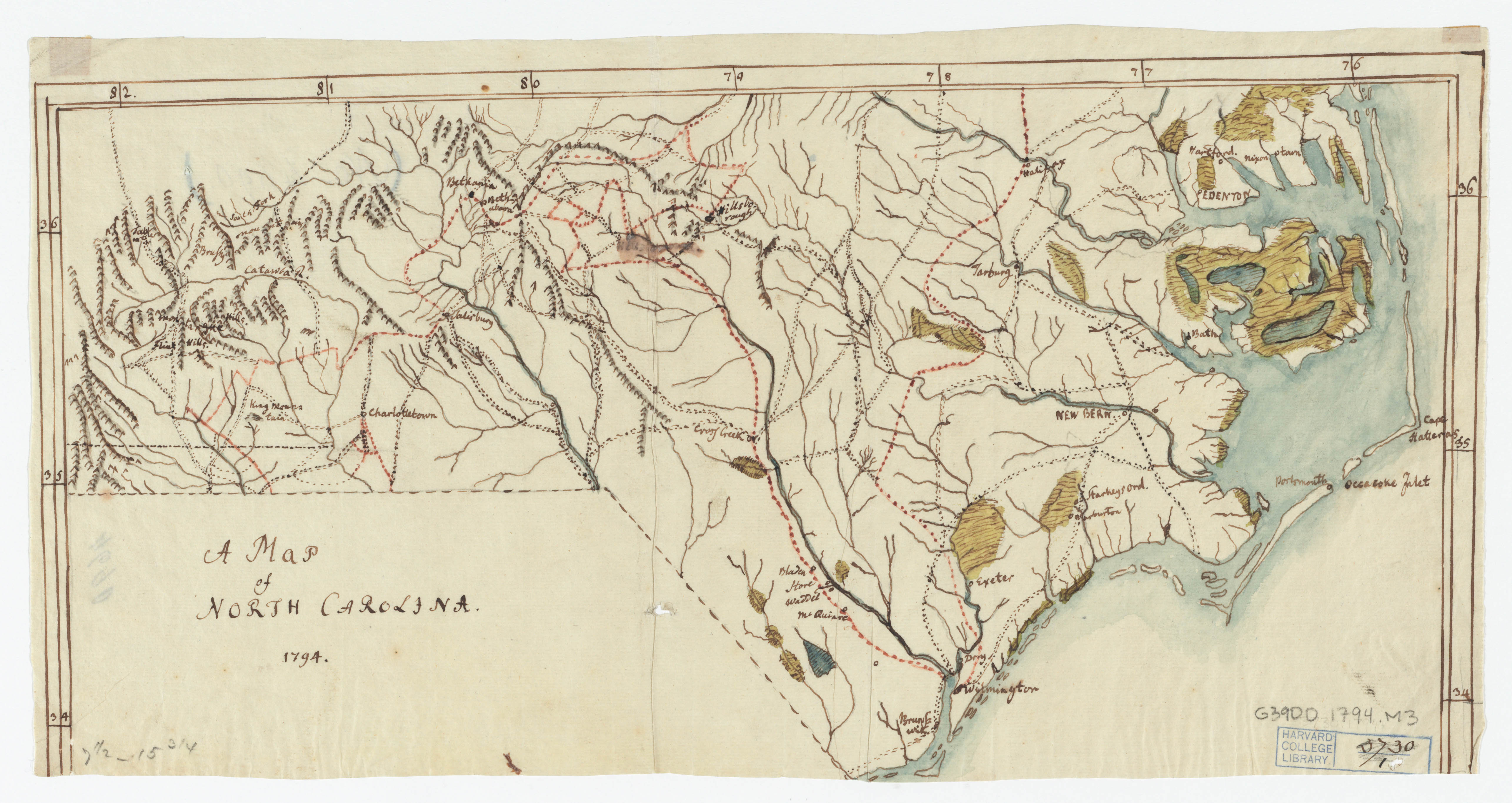
English: Shows names of cities, towns, and boundary with South Carolina.
Ms. map, pen-and- ink drawing likely traced by Christophe Daniel Ebeling. Relief shown pictorially. Prime meridian: London. Original map appears in American geography / by Jedidiah Morse ; Harrison, sc. Piccadilly, London: by J. Stockdale, July 24th, 1794. Collections and items have been digitized with the generous support of The Polonsky Foundation. |
| Date | |
| Source | http://id.lib.harvard.edu/aleph/010080121/catalog |
| Author | Ebeling, Christoph Daniel, 1741-1817 [copiest];Morse, Jedidiah, 1761-1826.;Stockdale, John, 1749?-1814.;Harrison, William, approximately 1750-1803. |
| Permission (Reusing this file) |
This is a media file that the Harvard Map Collection believes to be in the public domain of the United States. This applies to a work published before January 1, 1923, or the unpublished work of an author who died more than 70 years ago. The Harvard Map Collection and Harvard University claim no rights in this photographic reproduction of the work. The image is free to download and reproduce for any use, commercial or non-commercial, without any further permission required. Where these media files are used, The Harvard Map Collection asks to be credited as: Courtesy of Harvard Map Collection, Harvard Library, https://iiif.lib.harvard.edu/manifests/view/drs:426558493$1i. If this media file infringes your rights or the rights of any third parties, or if the file is not properly identified or acknowledged, please contact: maps@harvard.edu. Read more about the Harvard Library Policy on Access to Digital Reproductions of Works in the Public Domain on the HL Office of Scholarly Communication website |
| Camera location | | View this and other nearby images on: OpenStreetMap |
|---|
Licensing
|
This work is in the public domain in its country of origin and other countries and areas where the copyright term is the author's life plus 70 years or fewer. This work is in the public domain in the United States because it was published (or registered with the U.S. Copyright Office) before January 1, 1929. | |
| This file has been identified as being free of known restrictions under copyright law, including all related and neighboring rights. | |
File history
Click on a date/time to view the file as it appeared at that time.
| Date/Time | Thumbnail | Dimensions | User | Comment | |
|---|---|---|---|---|---|
| current | 21:04, 19 January 2018 | | 5,140 × 2,731 (1.33 MB) | Librarian lena | User created page with UploadWizard |
File usage
The following pages on the English Wikipedia use this file (pages on other projects are not listed):