Ruggell
Ruggell | |
|---|---|
 | |
 Ruggell in Liechtenstein | |
| Coordinates: 47°14′36″N 9°31′48″E / 47.24333°N 9.53000°E | |
| Country | |
| Electoral district | Unterland |
| Villages | None |
| Area | |
| • Total | 7.38 km2 (2.85 sq mi) |
| Elevation | 433 m (1,421 ft) |
| Population (31-12-2019)[1] | |
| • Total | 2,322 |
| • Density | 310/km2 (810/sq mi) |
| Time zone | UTC+1 (CET) |
| • Summer (DST) | CEST |
| Postal code | 9491 |
| Area code | 7010 |
| ISO 3166 code | LI-06 |
| Website | www.ruggell.li |
Ruggell (German pronunciation: [ʁuˈɡɛl] ⓘ) is a municipality of Liechtenstein. It is the northernmost and lowest elevated municipality. As of 2019, it has a population of 2,322.[1]
History[edit]
The name is said to be from the Latin for "clearing the land" (roncale - ad roncalem). Most known for conservation areas and the historic St. Fridolin's Parish Church.
Geography[edit]
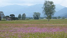
While Liechtenstein is known as a largely mountainous country, Ruggell is largely flat and is situated along the Rhine River, where the international borders with Switzerland and Austria meet. On 13 August 2003, Ruggell had a temperature of 37.4 °C (99.3 °F), which is the highest temperature recorded in Liechtenstein.
Flora and fauna[edit]

On the north side of the Eschnerberg mountain is located the roughly 90-hectare nature reserve Ruggeller Riet, rich in fauna and especially in flora.[2][3] The great biodiversity of the Ruggeller Riets includes peat moss, moor grass, Kleinseggenrieder and bogrush. At the end of May to June, the siberian iris blooms in the large parts of the nature reserve.[3] 736 plant and 1,631 animal species occur in the Ruggeller Riet, among them the white stork and the Eurasian curlew, which has disappeared as a breeding bird since 1997.[4]
The Ruggeller are popularly called "Lättaknätter". The loamy soil that occurs here is called "Lätta". In the past peat was used to heat houses during cold season. This ancient tradition has increasingly disappeared in recent years.[5]
Sport[edit]
Municipality is famous for FC Ruggell, one of the best teams in the country, although it plays in the sixth division of Switzerland. In other sporting areas cycling, field hockey, skiing, and other winter sports stand out. In addition, the town of Ruggell has one of the four sports halls of Liechtenstein; the others are in Schaan, Vaduz, and Balzers.
Notable people[edit]
- Klaus Tschütscher (born 1967) a politician from Liechtenstein, twelfth Prime Minister of Liechtenstein 2009–2013, lives in Ruggell.
- Marcel Tschopp (born 1974 in Ruggell) a Liechtensteiner orienteer and track athlete, specializing in the marathon; was Liechtenstein's flag bearer for the opening ceremony of the 2008 Summer Olympics
- Benjamin Büchel (born 1989 in Ruggell) international footballer who plays for FC Vaduz.
References[edit]
- ^ a b Bevölkerungsstatistik
- ^ Tourismus, Schweiz. "Unique flora in the Rugeller Riet". Switzerland Tourism.
- ^ a b Naturschutzgebiet Ruggeller Riet. On the website of the municipality of Ruggell, accessed on 16 June 2019
- ^ Felice, Nidija; Merz, Anna (31 December 2011). "Ruggeller Riet". Historisches Lexikon des Fürstentums Liechtenstein online (in German). Retrieved 27 July 2021.
- ^ "Peat fires, turf fires, cooking over peat, stacks, cutting spades, carrying peat home". www.oldandinteresting.com.
External links[edit]
![]() Media related to Ruggell at Wikimedia Commons
Media related to Ruggell at Wikimedia Commons
- Official website (in German)


