
Afon Ysgethin
| Afon Ysgethin | |
|---|---|
 Afon Ysgethin in Coed Cors-y-gedol | |
| Location | |
| Country | Wales |
| County | Gwynedd |
| Physical characteristics | |
| Source | |
| • location | Dyffryn Ardudwy |
| Mouth | |
• location | Tal-y-bont, Dyffryn Ardudwy |
The Afon Ysgethin is a short river in Gwynedd, Wales. Flowing entirely within Snowdonia National Park it rises beneath the peaks of Y Llethr and Diffwys within the Rhinogs mountain range and runs in a generally ESE direction towards Cardigan Bay.
Headwater streams flow into a small upper lake, Llyn Dulyn, and Llyn Bodlyn reservoir. Originally a natural lake, Llyn Bodlyn was enlarged in 1894 to provide Barmouth with water.[1] The river emerging from the reservoir is crossed by a historic track at Pont Scethin. This old stone arch bridge ("probably 18th century") was once used by packhorses and drovers moving between Harlech and London.[2]
A further 3 km downstream the river enters a narrower wooded valley and is crossed by Pont Fadog. An inscription on the bridge states that it was improved in 1762 by a mason called H. Edward, who was commissioned by William Vaughan, a member of the powerful owner family of nearby Cors-y-gedol hall (see Dyffryn Ardudwy).[3]
There are two further crossings at the village of Tal-y-bont: by the A496 road and by the Cambrian Coast railway. After another 1 km, the Afon Ysgethin enters the sea.[4]
Gallery[edit]
-
 Llyn Bodlyn
 -
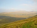
 Pont Scethin and Moelfre
 -
 Pont Fadog
 -
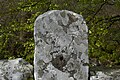 Inscription on Pont Fadog: W.V. 1762. H. Ed. saer (saer: mason)
 -
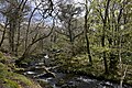 Coed Cors-y-gedol, the small "rain forest" below Pont Fadog


References[edit]
- ^ Roberts, Geraint. The Lakes of Eryri. Llanrwst: Carreg Gwalch, 1995.
- ^ "Pont Scethin Packhorse Bridge (24197)". Coflein. RCAHMW. Retrieved 29 September 2021.
- ^ "Pont Fadog, Dyffryn Ardudwy". britishlistedbuildings.co.uk. Retrieved 4 December 2021. — "Pont Fadog (24182)". Coflein. RCAHMW. Retrieved 4 December 2021.
- ^ OL 23 Cadair Idris & Llyn Tegid (Map) (A1 ed.). 1:25,000. Explorer. Ordnance Survey. 2005. ISBN 0319236226.