
File talk:Agni Missile Range comparison.png
| This is the talk page for discussing improvements to the Agni Missile Range comparison.png page. |
|
 | This orphaned talk page, subpage, image page, or similar is not eligible for speedy deletion under CSD G8 as it has been asserted to be useful to Wikipedia. If you believe it should be deleted, please nominate it on Wikipedia:Miscellany for deletion. |
Thank you..[edit]
..for correcting my inapt inclusion of image about the range of Agni VI SLBM. You are indeed right. SLBMs don't have a static target-range from the border. I must clarify though I wasn't trying to "mislead" anyone. Thanks again. Mrt3366 (Talk?) 01:25, 24 May 2012 (UTC)
- Of course you wern't trying to mislead anyone. I meant that the image was misleading. But thanks for the new pics! Maybe you can make a new one, with all the agni series missiles ranges as concentric circles, like the one currently given by ChanakyatheGreat. Anir1uph (talk) 08:05, 24 May 2012 (UTC)
- See if this one (at our right) is workable or not. Mrt3366 (Talk?) 13:21, 25 May 2012 (UTC)
- (talk page stalker) the image is cool but it lacks perfect clarity.However..it is acceptable...nice work...
 ƊṨṫƦⓘ₭ϱ𝝨Ƌǥɭϱ Ω 13:46, 25 May 2012 (UTC)
- Lacks clarity as in? I may be able to improve it. Just suggest some changes to improve it. Mrt3366 (Talk?) 15:04, 25 May 2012 (UTC)
- hint: they cant be circles, because for max range they will be launced from the tips of the indian subcontinent like Arunachal, Leh, Gujarat, Kanyakumari, Andaman Islands. Thats why the old image is not circles. -- ÐℬigXЯaɣ 15:51, 25 May 2012 (UTC)
- (talk page stalker) the image is cool but it lacks perfect clarity.However..it is acceptable...nice work...
- See if this one (at our right) is workable or not. Mrt3366 (Talk?) 13:21, 25 May 2012 (UTC)
- Exactly! the missile ranges would follow the rough outline of india. Btw, i did not understand why there are 2 white lines for agni 6. Also, Agni 1, 2 and 3 would also have to be shown, as they are the ones that are going to be operational for the next 3-4 years.. But great job! Anir1uph (talk) 20:09, 25 May 2012 (UTC)
- By the way, please do not take range from Andaman n Nicobar. There has been no indication by the armed forces of installing missile silos or mobile ICBMs on those islands. The range must be taken from the mainland India. Thanks! Anir1uph (talk) 20:13, 25 May 2012 (UTC)
- No the missile range will not follow the rough outline, it will be a distorted ellipse. And Why not Andaman DRDO has clearly stated that even Agni V can be launched by canister. Besides we have a strong military base at the Andaman, what makes you think India will not deploy its missiles over there ? -- ÐℬigXЯaɣ 20:32, 25 May 2012 (UTC)
- It will follow the rough outline of the indian mainland, as shown in the image by ChanakyatheGreat. Placing ICBM on the island chain would be a major geopolitical decision. Since there are no indications (even rumors) of India placing the missile there, we should follow the general idea of the previous image by ChanakyatheGreat and just add range for the Agni-VI missile. (For conversation's sake: Firstly, remember the Cuban missile crisis? Secondly, it will be must more effective to arm nuclear subs with SLBMs. Plus, Port Blair based Tri-Command is not a major base yet. It comprises of an Army brigade, an airforce strip & squadron and a relatively small naval port.)Anir1uph (talk) 20:53, 25 May 2012 (UTC)
- No the missile range will not follow the rough outline, it will be a distorted ellipse. And Why not Andaman DRDO has clearly stated that even Agni V can be launched by canister. Besides we have a strong military base at the Andaman, what makes you think India will not deploy its missiles over there ? -- ÐℬigXЯaɣ 20:32, 25 May 2012 (UTC)
I did not get your reference to Cuba M.C. being canister/mobile launch able means it can be transported by conventional means to any location, can you please elaborate why it can not be transported to Andaman ?-- ÐℬigXЯaɣ 21:03, 25 May 2012 (UTC)
- Placing ICBMs near friendly countries would be a major geopolitical decision which will not go unreported. If India does that, we can modify the image. For all countries, max missile ranges are shown from the mainland, and not extended due to islands eg China, USA. The question is not about transportation. If you can show me any reliable source/defense journal/mil research paper/think tank that says that the Agni series missiles can be placed at the Andaman & Nicobar Islands, then I am all up for extending the range. Anir1uph (talk) 21:11, 25 May 2012 (UTC)
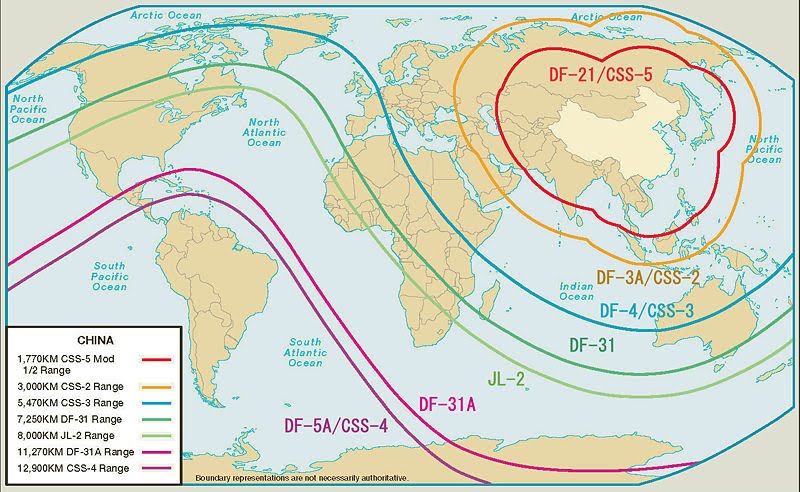
- you can see these - US missiles are on their mainland, not on their numerous islands in the pacific or indian ocean; the chinese missile ranges; and just for comparison, the Pakistani missile ranges.
- Thanks for the pics Anir, although its not very clear from pak and N korean images about the islands as they are close to the mainland. Chinese islands are located at distance. For the time being lets stick to the mainland based diagram with an option to include range from Andaman if we have sources supporting it (just trying to follow wp:NOR here) -- ÐℬigXЯaɣ 21:44, 25 May 2012 (UTC)
Agree with DBX....as the missiles are canister launched..they are mobile and can even be launched from ANI.......
@DBX...what islands of PRC were you talking about?
@Mrt...nothing serious...the borders of countries were not clearly visible and two ranges for A-6 confused me a bit.Got it now though..great job.. ƊṨṫƦⓘ₭ϱ𝝨Ƌǥɭϱ Ω 05:07, 26 May 2012 (UTC)
- I meant the chinese map appears to exclude the islands of china(i am not sure which islands exactly) but it seems the map is given from the mainland china-- ÐℬigXЯaɣ 05:50, 26 May 2012 (UTC)
- yeah....but there are no islands of PRC except Hainan Island which is just a few kms from mainland.Apart from this....only Taiwan is the island claimed by PRC but has no control over it(u already know it right)...so only Hainan is the island of China.Thanks ƊṨṫƦⓘ₭ϱ𝝨Ƌǥɭϱ Ω 06:31, 26 May 2012 (UTC)
- If thats the case then i guess we should include Andamans as well, they are undisputed indian territories with a military base, so its enough evidence to include it in the figure. this picture shows the reach of India's missiles, India decides to place missiles at Andaman or not is another question for another day. For this range picture, its perfectly ok to include it, so I change my stand now and support inclusion of Andaman in the range. The assumptions taken while drawing the image needs to be included in the description of the image-- ÐℬigXЯaɣ 07:15, 26 May 2012 (UTC)
- yeah....but there are no islands of PRC except Hainan Island which is just a few kms from mainland.Apart from this....only Taiwan is the island claimed by PRC but has no control over it(u already know it right)...so only Hainan is the island of China.Thanks ƊṨṫƦⓘ₭ϱ𝝨Ƌǥɭϱ Ω 06:31, 26 May 2012 (UTC)
Please refer to List of islands of the People's Republic of China. Please also refer to List of islands of Russia and List of islands of the United States. None of the nuclear powers have ever placed nuclear tipped ICBM on any of their island chains. USSR tried doing it in Cuba with disastrous results. There is no indication, historical or political that India would do so. Even if you recklessly make an image of the range from Andaman islands, and upload it to commons, it will not be used in any wikipedia article, due to wrong interpretation, original research and without any cited source backing the date shown in the image. Thanks! Anir1uph (talk) 15:49, 26 May 2012 (UTC)
- Cuba is not a part of USSR while Andaman is a part of India, Similar to Alaska of USA and US has missiles at Alaska.
- The difference will not be very substantial as we are talking of distances of the order of 4-5000 Kms. and not 2-300Kms
- The assumption of the tips such as Arunachal, leh, gujarat, andaman will be clearly mentioned in the description page of the image. so that is not an issue.
- as far as backing by suitable source is concerned so far we only know that they are launched and located at wheelers island orissa. The assumption of arunachal etc are standard assumption based on military deployment and theres nothing wrong in that. -- ÐℬigXЯaɣ 16:47, 26 May 2012 (UTC)
- Although, I agree with your point on legitimacy of placing nukes on Andaman, I'm highly skeptical that it will ever materialize. Having said that, we are not here to predict future strategic steps of the Cabinet Ministry of Republic of India.
In that sense, we should include Andaman as an extremity of India while projecting Missile ranges because it's indisputably a part of India. But if we take them as reference, the lines won't be regular in shape. The image won't probably so artistic as the one chanakya made. They will look like arbitrary lines. But we can do that too. Mrt3366 (Talk?) 18:35, 26 May 2012 (UTC)
- Although, I agree with your point on legitimacy of placing nukes on Andaman, I'm highly skeptical that it will ever materialize. Having said that, we are not here to predict future strategic steps of the Cabinet Ministry of Republic of India.
- Cuba was doing what USSR wanted it to do. There is no essential difference here.
- Alaska is not an island.
- The assumption we take is the probable places a country can place its ICBMs. (Off topic: An insecure island chains, prone to earthquake and tsunamis, providing no strategic benefit, only increasing suspicion of friendly neighboring countries etc) The main thing here is there is no reason India would place any missiles there. No country has done that, and to assume so is original research.
- Please see Diego Garcia, an island, with a very large US military base, in the middle of the Indian Ocean. US missile ranges are taken from the continental US (which includes Alaska btw), not from any island base such as Diego Garcia, or Oahu, Hawaii. Similarly, the United Kingdom's Falkland Islands, in the South Atlantic Ocean, where it even fought a war with Argentina, did not install ICBMs or any ballistic missile base on it, even though it is a major Royal military base. Unless we can find anywhere that India intends to place ballistic missiles on the island, we cannot assume so. Anir1uph (talk) 00:55, 27 May 2012 (UTC)
- While I agree with most of the things you wrote, and especially since we're all talking in pragmatic terms, it behoves me to inform you that USA already has nukes stacked up all over the map. US nuclear weapons are deployed in five-six European states:
- Belgium,
- Germany,
- Italy,
- the Netherlands and
- Turkey.
- Some of them are hosting U.S. nuclear weapons for years and Nuclear weapons are also aboard warships on international water (i.e. on some carrier strike groups with virtually unlimited range), so when we take that into account, practically USA doesn't need to put nukes on that puny island Diego Garcia unless it perceives a severe threat from either Southern African nations or Australia (even then it would be unnecessary but understandable strategic move). Mrt3366 (Talk?) 03:19, 27 May 2012 (UTC)
- While I agree with most of the things you wrote, and especially since we're all talking in pragmatic terms, it behoves me to inform you that USA already has nukes stacked up all over the map. US nuclear weapons are deployed in five-six European states:
agree with Mrt, see we do not have to ponder what fiji will think or what NZ aur Aus will think. while drawing missile range for N korea people do not think what its best friend China will think (or their best friendship might be in jeopardy), we are making a range map for Agni missiles and it should include the range from andaman as it can be fired from andaman. Whether they deploy or not , or fire or not or test or not at andaman , is none of our business. DRDO has already clarified that being canister launchable it can be launched from anywhere in India, thats enough of an evidence to include All Indian territories, unless its logistically impossible to transport it to that area. And Andaman is not that exception. -- ÐℬigXЯaɣ 05:20, 27 May 2012 (UTC)
- But, DBX considering the status quo of wikipedia we shouldn't include the islands in the same picture. In that sense we have to ask ourselves how many islands are we going to count? I think the current pic is enough to give viewers a rough idea of what India's nuclear range is. I hope you get my point. Mrt3366 (Talk?) 17:36, 27 May 2012 (UTC)
- I think you're right but just understand that doing so will not change anything. We're not talking about Agni VII (at this stage it's fair to say that there might be another Agni after Agni VI, right?), but we aren't talking about it, why?
Because we don't think it would be unrealistic as well as unreasonable to the readers and we don't know if it exists at all. Now, I admit there is not that much uncertainty here, but there is some uncertainty here.
Just like it will be conceivably unrealistic to draw range-projections of US nukes from Diego Garcia since they don't need it.
Coming back to our topic, we may very well draw projections of nuke-range from Andaman, Nicobar, and even Lakshadweep island chains, without the patronage of probability that India will ever make such a consequential and antagonizing move, but it will be perceived as a tad unrealistic step, or perhaps as desperation on our part because India doesn't need it in the first place.
Although what you're saying is legitimate, I don't think that will reflect the true likelihood of nuke-placement. We've got to be realistic. Otherwise it will be our personal interpretation of the probable. We must provide the information about what the authorities will likely do, not what we think they should do. Do you get me now? Mrt3366 (Talk?) 18:12, 27 May 2012 (UTC)
- I think you're right but just understand that doing so will not change anything. We're not talking about Agni VII (at this stage it's fair to say that there might be another Agni after Agni VI, right?), but we aren't talking about it, why?
- please do not add Agni VII.about Diego garcia remember US has submarines with nuke tipped cruise missiles, its already stated above.
- We should not discuss if India could / would / should deploy it at andaman, thats beyond our scope. The fact is they can be deployed at andaman, if need be and hence we have included them in the figure. as simple as that. --ÐℬigXЯaɣ 19:28, 27 May 2012 (UTC)
- “We should not discuss if India could / would / should deploy it at andaman, thats beyond our scope.” - Yes, instead we should focus on what's likely.
“The fact is they can be deployed at andaman” - ask yourself, what does "can" really stand for here?
Yes, it is physically possible. But it's politically improbable and I dare say, nearly "impossible". Mrt3366 (Talk?) 19:50, 27 May 2012 (UTC)
- “We should not discuss if India could / would / should deploy it at andaman, thats beyond our scope.” - Yes, instead we should focus on what's likely.
My perception of Consensus[edit]
So I will list some of the needed changes. But I should inform you guys that I deliberately eschewed the discussion as I am myself confused. But now, I think I can venture some guesses as to what the needed changes might be,
| Probable Changes | My agreement | Extra note |
|---|---|---|
| The projected range cannot be circular. | I think we should not aim to achieve 100% accuracy since the maps themselves aren't 100% accurate. | |
| The range-projection will not be a rough outline of India | The shape is a rough projection. We may state it in the diagram that the image is not 100% accurate. So, I don't think the geometrical eccentricity really matters here. Other range projecting diagrams also don't take into account all these factors. While the exact shape of the covered-area (as in targetable land) might be worth considering but what difference will that make since we don't have a perfect map or exact range? | |
| While depicting the projected range we should take into account Indian territories outside the mainland (e.g. Andaman & Nicobar Islands) | Clarification needed: Should I make a separate range projection for the Islands? As Anir1uph (talk · contribs) stated although it's possible, it's improbable at this stage, since India's main objective is to get China into range and not Australia or New Zealand or Fiji Islands. |
Feel free to weigh in.
Your opinion is important, so what do you guys suggest? Are these enough or any other change needed to be considered? I am willing to make another image, this time more assiduously. I concede the last image was just for demonstration purposes. Mrt3366 (Talk?) 16:15, 26 May 2012 (UTC)
- Mrt lets first get a consensus in the above section, once we have it we can tabulate the inference here. So i will suggest you to participate in the above section as well -- ÐℬigXЯaɣ 16:51, 26 May 2012 (UTC)
An illustration of Agni Missile Ranges (New face)[edit]
Like the new face? Now, carry on with the discussion and quickly let me know if this isn't alright. Mrt3366 (Talk?) 22:20, 26 May 2012 (UTC)
- Agni II & III isn't mobile, so cannot be placed on the islands. You already know about my objection to include the islands for Agni IV & V, but i guess there will not be a lot of difference. Finally, the top part of the image needs work. The caption can be at the bottom, or altogether removed to make the image look neat. Great work tho! Anir1uph (talk) 00:33, 27 May 2012 (UTC)
- Okay, I'm on it. BTW, I didn't include the islands. Had I included the Islands, the range of Agni V would have passed beyond Perth, Western Australia. I simply took
Agni II's range as 2,100 kilometres (1,300 mi) [which is min 500 kilometres (310 mi) less than what was publicized]
Agni III's range as 3,200 kilometres (2,000 mi) [which is 300–1,000 kilometres (190–620 mi) less than what's been touted by some high-ranking officials]
Agni V's range as 5,500 kilometres (3,400 mi) [which is at least 300 kilometres (190 mi) less than what's been officially acknowledged and 2,500 kilometres (1,600 mi) less than what Chinese experts have suspected]. Mrt3366 (Talk?) 01:49, 27 May 2012 (UTC)- Is it okay now? Mrt3366 (Talk?) 02:31, 27 May 2012 (UTC)
- Mrt can you please let us know how you made the missile ranges on the map. As i somehow suspect that this is not correct, reason is the heartshape of the range, i guess it should appear more like a rhombus with rounded corners . I suspect you forgot to include Leh. have a look here [1]-- ÐℬigXЯaɣ 05:13, 27 May 2012 (UTC)
- To tell you the truth, heart-shape isn't my idea. It was adopted from another picture presently existing on the Agni V's page. But I can see why they made it shaped like a heart. Since India's outline is basically triangular and the ranges are circular from a fixed point. Homogeneous distribution of range-projection along the border of mainland of India will thus be heart-shaped. Mrt3366 (Talk?) 17:26, 27 May 2012 (UTC)
- if tamilnadu (deccan plateau) can give a tapering outline in the bottom south shouldnt the JnK also do something similar at the top in the north ? --ÐℬigXЯaɣ 17:33, 27 May 2012 (UTC)
- You must understand how nukes operate, you can always squeeze some 50–100 kilometres (31–62 mi) out of a missile like Agni V at the expense of some 50m of accuracy. This tolerance subsumes the tapering you are referring to. We, at wikipedia, can never predict with 100% percent accuracy what the nukes are capable of, what we can do is venture a guess to give the readers a rough idea. And let me inform you, not many scientists at DRDO can do that either. So why bother with these minuscule irregularities of shape at all? It's about rough idea. If you had to predict with 95% accuracy we would need all sorts of perplexing algorithms, trust me, it's like calculating how blood flows through your veins and at what speed. Mrt3366 (Talk?) 17:46, 27 May 2012 (UTC)
- To tell you the truth, heart-shape isn't my idea. It was adopted from another picture presently existing on the Agni V's page. But I can see why they made it shaped like a heart. Since India's outline is basically triangular and the ranges are circular from a fixed point. Homogeneous distribution of range-projection along the border of mainland of India will thus be heart-shaped. Mrt3366 (Talk?) 17:26, 27 May 2012 (UTC)
- Mrt can you please let us know how you made the missile ranges on the map. As i somehow suspect that this is not correct, reason is the heartshape of the range, i guess it should appear more like a rhombus with rounded corners . I suspect you forgot to include Leh. have a look here [1]-- ÐℬigXЯaɣ 05:13, 27 May 2012 (UTC)
- Is it okay now? Mrt3366 (Talk?) 02:31, 27 May 2012 (UTC)
- Okay, I'm on it. BTW, I didn't include the islands. Had I included the Islands, the range of Agni V would have passed beyond Perth, Western Australia. I simply took
sounds wp:OR to me. please take the exact sourced range that is mentioned in the article while drawing the fig, also mention the range that you have taken in the description page of the image . Please include the range from top of jandk as well. it seems to be lacking in the given version. --ÐℬigXЯaɣ 18:50, 27 May 2012 (UTC)
- Original Research? How? What original research do you see in there? Please tell me what is it that you think I inserted in the image based on original research? Common sense is not original research. Geometry is not original research. It's a strictly geometrical problem that we're quibbling about here.
"Please include the range from top of jandk as well." - I have, but not from the extreme top of J&K (since India lost access to that portion years ago and haven't done anything to regain it from the clutches of China or Pakistan). And I told you that minor tapering is already included but it won't look like a tapering since the shape of a projection is circular and besides, that tapering doesn't even change the shape of range-projection substantially because even if it's somehow launched from the very top of JnK it will extend the range only to arctic ocean which is not included in the map for being irrelevant (I didn't right the code for the map and don't have other maps available to me). And still if you want me to undo some or all of my work and create another image predicated on our disagreement over the minutiae of the shape of the range that will not change anything and needless to say, incurring some amount of extra work, then I think you're being a little too adamant without any real need. I have tried to explain it to you. But, you're not listening. Mrt3366 (Talk?) 19:46, 27 May 2012 (UTC)
- relax buddy, i referred wp:OR to the statement where you were bargaining with the range. what we want is something like this [2] see the Shape of mainland India is closer to a rhombus so the missile range must also be closer to a rhombus not a heart or semi-rhombus. thats exactly my point. I am more than ready to listen:) --ÐℬigXЯaɣ 20:14, 27 May 2012 (UTC)
- relax buddy,
- Agree with DBX...the original image is inaccurate and needs replacement.BTW...it was made by Chanakya....I donot understand what assumptions he took while making it. ƊṨṫƦⓘ₭ϱ𝝨Ƌǥɭϱ Ω 15:50, 28 May 2012 (UTC)
- I guess he used only the coastal border as the location of JandK is not clear in this physical map of the world, but such an assumption is clearly wrong as i have showed above--ÐℬigXЯaɣ 15:53, 28 May 2012 (UTC)
- I couldn't see the borders, so that is not entirely intentional. Thanks for pointing it out though. I am going to do something about the borders and the projection now and upload a new version of the image, albeit it may take days, or even weeks. BTW you're right, this picture does seem like having the same problem. Just give me time. Mrt3366 (Talk?) 05:21, 30 May 2012 (UTC)
- I guess he used only the coastal border as the location of JandK is not clear in this physical map of the world, but such an assumption is clearly wrong as i have showed above--ÐℬigXЯaɣ 15:53, 28 May 2012 (UTC)
- Agree with DBX...the original image is inaccurate and needs replacement.BTW...it was made by Chanakya....I donot understand what assumptions he took while making it. ƊṨṫƦⓘ₭ϱ𝝨Ƌǥɭϱ Ω 15:50, 28 May 2012 (UTC)
it seems like that...... the above image clearly shows that the projection is completely wrong and is not on scale like the Chinese missile range image you previously showed here. ƊṨṫƦⓘ₭ϱ𝝨Ƌǥɭϱ Ω 15:58, 28 May 2012 (UTC)
- Thanks for responding Mrt, take your time, I am sure with more time you will come up with a best image, why dont you try a political map of the world ? --ÐℬigXЯaɣ 05:57, 30 May 2012 (UTC)
- Agree with DBX..political map looks better. ƊṨṫƦⓘ₭ϱ𝝨Ƌǥɭϱ Ω 05:59, 30 May 2012 (UTC)
- the current version appears correct, good work Mrt. Can you please create another map including Andaman, just wanted to see the difference. (if that does not trouble you much.) thanks--ÐℬigXЯaɣ 06:52, 30 May 2012 (UTC)
- Is the new one okay? Now see the distances of northern hemispheres are going to look comparatively shorter due to the spherical shape and thus the gradient of surface of the earth. Mrt3366 (Talk?) 06:54, 30 May 2012 (UTC)
"Can you please create another map including Andaman"
- I will see what I can do. BTW, I don't think should we include Andaman. My view is predicated on the sheer unlikelihood of the whole idea of India placing nukes in Andaman. Mrt3366 (Talk?) 06:57, 30 May 2012 (UTC)
- yup I know about the spherical, distortions. I value your opinion, but we do not make political decisions, we are here to state the fact of the range of missiles from India and thats what we will do, Please do it whenever you get time. I wil try to get more consensus on this issue of Andaman. --ÐℬigXЯaɣ 07:03, 30 May 2012 (UTC)
- Agree with DBX..political map looks better. ƊṨṫƦⓘ₭ϱ𝝨Ƌǥɭϱ Ω 05:59, 30 May 2012 (UTC)
- Nice work mrt..it is fine now.However, as DBX said, try a version with ANI included for reference and comparison.I've uploaded another version of the same image(with another name) in which I highlighted the range of Agni-VI which was quite pale in the original one. Please comment. ƊṨṫƦⓘ₭ϱ𝝨Ƌǥɭϱ Ω 08:28, 30 May 2012 (UTC)
while this version seems perfect, but i have a personal opinion, feel free to disagree and reply below. I guess Chanakya's blue shades were somehow better than the combination of pink and yellow. to me it looks a bit gloomy, have you tried different shades of sky blue, what say ? --ÐℬigXЯaɣ 09:47, 30 May 2012 (UTC)

With blue shades - Though the colours look good..a lot needs to be done.I mean the projections do not appear in the top.mrt...can you correct that? ƊṨṫƦⓘ₭ϱ𝝨Ƌǥɭϱ ® 11:02, 30 May 2012 (UTC)
- Mrt will it be possible for you to make the continents look more paler as in File:Agni_missile_range.svg, it would be better that way, and then use shades of sky blue. what is your opinion on it? --ÐℬigXЯaɣ 12:09, 30 May 2012 (UTC)
Mrt will it be possible for you to make the continents look more paler as in File:Agni_missile_range.svg, it would be better that way
- While it's not entirely impossible, it's a little extra-work and I have some minor personal reservation against the brightness, or as you put it - paleness of the continents because it renders the international borders practically indistinguishable and in range projections the visibility of international borders is very, very important, but feel free to experiment and upload (if possible, under new names for future references). Thank you."but we do not make political decisions" - exactly, albeit we do not add anything based on our opinions too. What we do here is reflect the political opinions and perspective realistically basing on the information we have, as opposed to our own judgements and whims. That's the reason why we don't make nuclear range projections of the United states including the Diego Garcia island or the countries where the nukes are already in place under US authority. We have to maintain the status quo in order to make it compatible to NPOV. But I know, you disagree.
However, if you feel it's important, I can state it in this diagram that we didn't include the islands and make another diagram with a separate range-projection from the ANI, but then the question remains what islands are we going to include (since Agni V, and presumably Agni VI also, can be launched from any place inside Indian territory)? Mrt3366 (Talk?) 15:23, 30 May 2012 (UTC)
- I dont think there is much difference in the visibility of the International boundary between the countries in the map File:Agni_missile_range.svg and also File:Agni Missile Range comparison highlighted.png or File:Agni Missile Range comparison.png the idea of making the continents darker Doesnt serve any visual purpose as it makes no difference. In fact the dark continents reduce the appearance of the range. by conflicting (to some extent) with the colours of the issile range. --ÐℬigXЯaɣ 08:11, 31 May 2012 (UTC)
- You know Diego garcia is not a US territory, but Andaman indisputably is, excluding Andaman from Indian missile range is a POV, and OR. As i said above i will seek consensus from other senior editors who have more experience in this to make a consensus. regards--ÐℬigXЯaɣ 08:11, 31 May 2012 (UTC)
- "the idea of making the continents darker Doesnt serve any visual purpose as it makes no difference." - with all due respect, I think it does.
"You know Diego Garcia is not a US territory" - yes, but it's the territory of UK and they have signed an agreement with USA. Even if I grant you that it is not a territory of US, it doesn't affect my position which is that we don't include content based on our own judgements. Nevertheless, let me rephrase, we don't make nuclear range projections of the United kingdom from the Diego Garcia island or nuke range projections of the United states including countries where the nukes are already in place under the authority of US army. We have to consider what's probable (a narrow subset of possibility) as opposed to anything that's possible. As anir1uph said, "placing ICBMs near friendly countries would be a major geopolitical decision which will not go unreported. If India does that, we can modify the image."
"As i said above i will seek consensus from other senior editors who have more experience in this to make a consensus." - I will gracefully accept the consensus and defer to it. We may very well draw projections of nuke-range from Andaman, Nicobar, and even Lakshadweep island chains, I don't mind. There's no ego involved here, if that's what you are thinking. And I agree that there is a difference between US's authority over Diego Garcia and India's sovereignty over ANI. Mrt3366 (Talk?) 08:40, 31 May 2012 (UTC)
- "the idea of making the continents darker Doesnt serve any visual purpose as it makes no difference." - with all due respect, I think it does.
- Mrt will it be possible for you to make the continents look more paler as in File:Agni_missile_range.svg, it would be better that way, and then use shades of sky blue. what is your opinion on it? --ÐℬigXЯaɣ 12:09, 30 May 2012 (UTC)

The latest version of the image isn't showing.[edit]
Image now shows and issue resolved
|
|---|
|
I've uploaded yet another version of this image per Anir1uph's request. But, why is it not showing when the image is embedded? Mrt3366 (Talk?) 07:28, 31 May 2012 (UTC)
wait checking--ÐℬigXЯaɣ 07:45, 31 May 2012 (UTC)
|
Suggestions requested on Colour of the map[edit]
Mrt will it be possible for you to make the continents look more paler as in File:Agni_missile_range.svg, it would be better that way, and then use shades of sky blue. what is your opinion on it? --ÐℬigXЯaɣ 12:09, 30 May 2012 (UTC)
- While it's not entirely impossible, it's a little extra-work and I have some minor personal reservation against the brightness, or as you put it - paleness of the continents because it renders the international borders practically indistinguishable and in range projections the visibility of international borders is very, very important, but feel free to experiment and upload (if possible, under new names for future references). Thank you. Mrt3366 (Talk?) 15:23, 30 May 2012 (UTC)
- I dont think there is much difference in the visibility of the International boundary between the countries in the map File:Agni_missile_range.svg and also File:Agni Missile Range comparison highlighted.png or File:Agni Missile Range comparison.png the idea of making the continents darker Doesnt serve any visual purpose as it makes no difference. In fact the dark continents reduce the appearance of the range. by conflicting (to some extent) with the colours of the missile range. --ÐℬigXЯaɣ 08:11, 31 May 2012 (UTC)
Clarification from Mrt3366, please take a look before replying
|
|---|
I understand neither the request in its entirety nor it's validity (because IMO personal preference is not a valid reason for modifying contents). Is this a request for reducing the contrast of the image or the brightness or the color of continents? I don't know if this is my monitor or the image, but I do see some difference in the prominence of the international borders. Mrt3366 (Talk?) 11:31, 31 May 2012 (UTC)
|
Based on this above discussion, please suggest your opinion with reasons so that it becomes easier for us to decide on the best colours that portrays info in the best way--ÐℬigXЯaɣ 09:15, 31 May 2012 (UTC)
suggestions[edit]
- Pale grey for continents and shades of sky blue for Missile ranges as given in File:Agni_missile_range.svg sky blue or purple for the missile range for reasons mentioned above--ÐℬigXЯaɣ 09:15, 31 May 2012 (UTC)
- Why? BTW, "it would be better that way" - isn't a valid rationale. So, could you please validate your request by expanding on the actual issue a little further ? I mean how do the borders in the current image fail to be completely discernible because of the color combination and how does your suggestion help? Mrt3366 (Talk?) 11:53, 31 May 2012 (UTC)
- Sure, see the subject of the map is the range of the missiles and how it affects the countries and continents. choosing a darker colour for continents conflicts with the colour of the missile range, making it less prominent. The boundaries of the nations in the paler SVG map is also clearly visible. --ÐℬigXЯaɣ 12:01, 31 May 2012 (UTC)
- Do you mean bright yellow conflicts with black? And thus your suggestion is to brighten up the darker continents so that it would not conflict with the light yellow anymore? I don't think it works like that. That's all
 .
.In SVG map there are 3 layers and in the new one there are 4 and that's a major barrier to the visibility of the continents. Mrt3366 (Talk?) 12:11, 31 May 2012 (UTC)
- Do you mean bright yellow conflicts with black? And thus your suggestion is to brighten up the darker continents so that it would not conflict with the light yellow anymore? I don't think it works like that. That's all
- Sure, see the subject of the map is the range of the missiles and how it affects the countries and continents. choosing a darker colour for continents conflicts with the colour of the missile range, making it less prominent. The boundaries of the nations in the paler SVG map is also clearly visible. --ÐℬigXЯaɣ 12:01, 31 May 2012 (UTC)
- Why? BTW, "it would be better that way" - isn't a valid rationale. So, could you please validate your request by expanding on the actual issue a little further
- I will not suggest the color combinations as you all are much better for that. Please continue with an appropriate, simple (not over cluttered) image, where the overlapping colors have contrast to make the image self explanatory. Thanks! And keep up the good work Mrt! Anir1uph (talk) 12:29, 31 May 2012 (UTC)
Image has got a major flaw[edit]
Look I saw the image contains range projections for Agni III but in the legend it provides the range for Agni IV. Could somebody correct that? It is a blatant flaw. I've added Agni VI to my watchlist. I would do it myself, but I don't know how. Brendon is here 13:14, 2 June 2012 (UTC)
- okay, I will correct that and change Agni IV → Agni III. Thank you. Mrt3366 (Talk?) 13:19, 2 June 2012 (UTC)
 Done Mrt3366 (Talk?) 13:28, 2 June 2012 (UTC)
- Yes, nice work. How do you do it exactly, if you don't mind me asking? Brendon is here 13:31, 2 June 2012 (UTC)
- It's not a big deal, with the help of adobe software anybody can do what I'm doing, and more. Mrt3366 (Talk?) 13:35, 2 June 2012 (UTC)