
File:Welshpool Town Hall - geograph.org.uk - 541059.jpg
Size of this preview: 450 × 600 pixels. Other resolutions: 180 × 240 pixels | 480 × 640 pixels.
Original file (480 × 640 pixels, file size: 136 KB, MIME type: image/jpeg)
| This is a file from the Wikimedia Commons. Information from its description page there is shown below. Commons is a freely licensed media file repository. You can help. |
Summary
| Description |
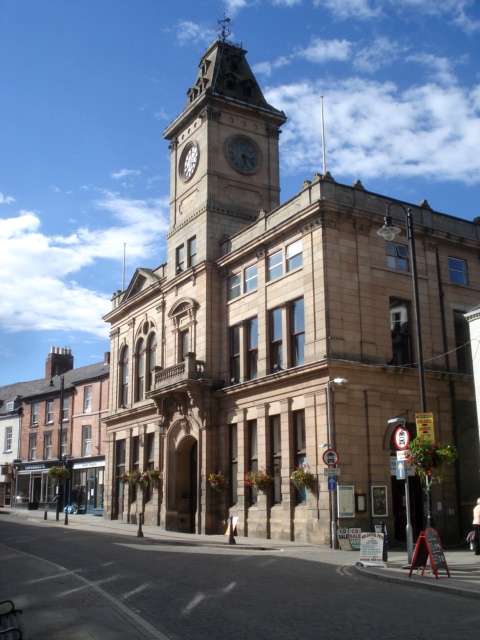
English: Welshpool Town Hall The original town hall was built in 1796. After successive extensions and enlargements it was demolished because it was considered too small. The whole was replaced in 1874 by the 'French neo-classical' building seen today, using yellow sandstone either from Shrewsbury or Flintshire. It now houses a market on Saturday and Monday and a Farmers Market on the first Friday of each month. |
| Date | |
| Source | From geograph.org.uk |
| Author | Trevor Rickard |
| Attribution (required by the license) | Trevor Rickard / Welshpool Town Hall / |
| Camera location | | View this and other nearby images on: OpenStreetMap |
|---|
_heading:0.00&language=en)
| Object location | | View this and other nearby images on: OpenStreetMap |
|---|
_heading:0.00&language=en)
Licensing

|
This image was taken from the Geograph project collection. See this photograph's page on the Geograph website for the photographer's contact details. The copyright on this image is owned by Trevor Rickard and is licensed for reuse under the Creative Commons Attribution-ShareAlike 2.0 license.
|
This file is licensed under the Creative Commons Attribution-Share Alike 2.0 Generic license.
Attribution: Trevor Rickard
- You are free:
- to share – to copy, distribute and transmit the work
- to remix – to adapt the work
- Under the following conditions:
- attribution – You must give appropriate credit, provide a link to the license, and indicate if changes were made. You may do so in any reasonable manner, but not in any way that suggests the licensor endorses you or your use.
- share alike – If you remix, transform, or build upon the material, you must distribute your contributions under the same or compatible license as the original.
File history
Click on a date/time to view the file as it appeared at that time.
| Date/Time | Thumbnail | Dimensions | User | Comment | |
|---|---|---|---|---|---|
| current | 01:15, 6 February 2011 | | 480 × 640 (136 KB) | GeographBot | == {{int:filedesc}} == {{Information |description={{en|1=Welshpool Town Hall The original town hall was built in 1796. After successive extensions and enlargements it was demolished because it was considered too small. The whole was replaced in 1874 by th |
File usage
The following pages on the English Wikipedia use this file (pages on other projects are not listed):
Global file usage
The following other wikis use this file: