
File:The site of Llanllibio Church - geograph.org.uk - 984595.jpg
No higher resolution available.
The_site_of_Llanllibio_Church_-_geograph.org.uk_-_984595.jpg (640 × 360 pixels, file size: 72 KB, MIME type: image/jpeg)
| This is a file from the Wikimedia Commons. Information from its description page there is shown below. Commons is a freely licensed media file repository. You can help. |
Summary
| Description |
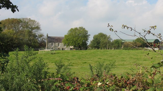
English: The site of Llanllibio Church. Tan-y-fynwent, the name of the house, becomes self explanatory when one finds that this was the site of the chapel of ease of Llanlleibio. The chapel was abandoned in the 17th century and soon became a ruin. Nothing is now left on the site, except for a slate gravestone commemorating all the dead, which can be seen right in front of the house.
984545 |
| Date | |
| Source | From geograph.org.uk |
| Author | Eric Jones |
| Attribution (required by the license) | Eric Jones / The site of Llanllibio Church / |
| Camera location | | View this and other nearby images on: OpenStreetMap |
|---|
_heading:292.00&language=en)
| Object location | | View this and other nearby images on: OpenStreetMap |
|---|
_heading:292.00&language=en)
Licensing

|
This image was taken from the Geograph project collection. See this photograph's page on the Geograph website for the photographer's contact details. The copyright on this image is owned by Eric Jones and is licensed for reuse under the Creative Commons Attribution-ShareAlike 2.0 license.
|
This file is licensed under the Creative Commons Attribution-Share Alike 2.0 Generic license.
Attribution: Eric Jones
- You are free:
- to share – to copy, distribute and transmit the work
- to remix – to adapt the work
- Under the following conditions:
- attribution – You must give appropriate credit, provide a link to the license, and indicate if changes were made. You may do so in any reasonable manner, but not in any way that suggests the licensor endorses you or your use.
- share alike – If you remix, transform, or build upon the material, you must distribute your contributions under the same or compatible license as the original.
File history
Click on a date/time to view the file as it appeared at that time.
| Date/Time | Thumbnail | Dimensions | User | Comment | |
|---|---|---|---|---|---|
| current | 02:05, 23 February 2011 | | 640 × 360 (72 KB) | GeographBot | == {{int:filedesc}} == {{Information |description={{en|1=The site of Llanllibio Church Tan-y-fynwent, the name of the house, becomes self explanatory when one finds that this was the site of the chapel of ease of Llanlleibio. The chapel was abandoned in t |
File usage
The following pages on the English Wikipedia use this file (pages on other projects are not listed):
Global file usage
The following other wikis use this file:
- Usage on vi.wikipedia.org
- Usage on www.wikidata.org