
File:St Mary's church - wall monument - geograph.org.uk - 704192.jpg

Size of this preview: 450 × 600 pixels. Other resolutions: 180 × 240 pixels | 480 × 640 pixels.
Original file (480 × 640 pixels, file size: 172 KB, MIME type: image/jpeg)
| This is a file from the Wikimedia Commons. Information from its description page there is shown below. Commons is a freely licensed media file repository. You can help. |
Summary
| Description |
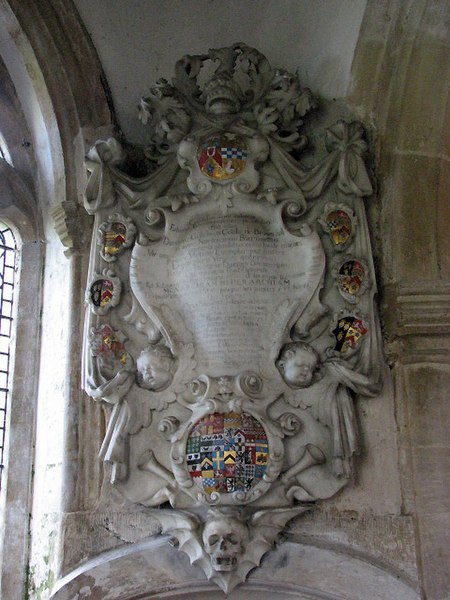
English:  St Mary's Church, Cranworth, Norfolk, mural monument to w:Sir William Cook, 2nd Baronet (c.1630-1708), of Broome Hall in Norfolk. Heraldry see: heraldryinnorfolk.wordpress.com[1]. For heraldry see File:Arms SirWilliamCook 2ndBaronet CranworthChurch Norfolk.svg The main features of St Mary's church date from the 14th century; the tower has a parapet and, unusual for Norfolk, a recessed spire. The lead roof is from 1919. The church furniture is elaborately carved from oak, the communion rail has a design of mouchette wheels. The church contains a number of interesting wall monuments, most of these to the Gurdons who lived at Letton Hall. The church is kept locked but a key is readily available. For more information see: http://www.norfolkchurches.co.uk/cranworth/cranworth.htm |
| Date | |
| Source | From geograph.org.uk |
| Author | Evelyn Simak |
| Attribution (required by the license) | Evelyn Simak / St Mary's church - wall monument / |
| Camera location | | View this and other nearby images on: OpenStreetMap |
|---|
_heading:157.00&language=en)
| Object location | | View this and other nearby images on: OpenStreetMap |
|---|
_heading:157.00&language=en)
Licensing

|
This image was taken from the Geograph project collection. See this photograph's page on the Geograph website for the photographer's contact details. The copyright on this image is owned by Evelyn Simak and is licensed for reuse under the Creative Commons Attribution-ShareAlike 2.0 license.
|
This file is licensed under the Creative Commons Attribution-Share Alike 2.0 Generic license.
Attribution: Evelyn Simak
- You are free:
- to share – to copy, distribute and transmit the work
- to remix – to adapt the work
- Under the following conditions:
- attribution – You must give appropriate credit, provide a link to the license, and indicate if changes were made. You may do so in any reasonable manner, but not in any way that suggests the licensor endorses you or your use.
- share alike – If you remix, transform, or build upon the material, you must distribute your contributions under the same or compatible license as the original.
File history
Click on a date/time to view the file as it appeared at that time.
| Date/Time | Thumbnail | Dimensions | User | Comment | |
|---|---|---|---|---|---|
| current | 23:08, 18 February 2011 | | 480 × 640 (172 KB) | GeographBot | == {{int:filedesc}} == {{Information |description={{en|1=St Mary's church - wall monument Memorial Sir William Cooke, who died in 1698. The main features of St Mary's church date from the 14th century; the tower has a parapet and, unusual for Norfolk, |
File usage
The following pages on the English Wikipedia use this file (pages on other projects are not listed):