
File:Scotts Creek, Lake County, CA USGS topo map.png
No higher resolution available.
Scotts_Creek,_Lake_County,_CA_USGS_topo_map.png (571 × 533 pixels, file size: 370 KB, MIME type: image/png)
| This is a file from the Wikimedia Commons. Information from its description page there is shown below. Commons is a freely licensed media file repository. You can help. |
Summary
| Description |
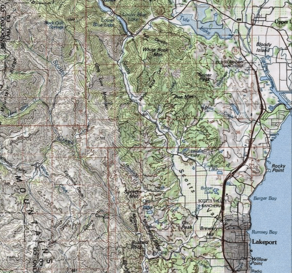
English: Scotts Creek, a tributary of Clear Lake in Lake County, California. The creek rises in the NW of the map, flows south, then southeast and then east towards Lakeport, then turns north up to the Blue Lakes, then east through Tule Lake to Rodman Slough |
| Date | |
| Source | https://geonames.usgs.gov/apex/gazvector.getesrimap?p_lat=38.9104546&p_longi=-122.6102614&fid=277549 |
| Author | USGS |
Licensing
This image is in the public domain in the United States because it only contains materials that originally came from the United States Geological Survey, an agency of the United States Department of the Interior. For more information, see the official USGS copyright policy.
|
File history
Click on a date/time to view the file as it appeared at that time.
| Date/Time | Thumbnail | Dimensions | User | Comment | |
|---|---|---|---|---|---|
| current | 11:58, 18 May 2021 | | 571 × 533 (370 KB) | Aymatth2 | Uploaded a work by USGS from https://geonames.usgs.gov/apex/gazvector.getesrimap?p_lat=38.9104546&p_longi=-122.6102614&fid=277549 with UploadWizard |
File usage
The following pages on the English Wikipedia use this file (pages on other projects are not listed):