
File:RomanEmpire 117 recoloured.svg

Size of this PNG preview of this SVG file: 800 × 587 pixels. Other resolutions: 320 × 235 pixels | 640 × 470 pixels | 1,024 × 752 pixels | 1,280 × 939 pixels | 2,560 × 1,879 pixels | 2,180 × 1,600 pixels.
Original file (SVG file, nominally 2,180 × 1,600 pixels, file size: 1.11 MB)
| This is a file from the Wikimedia Commons. Information from its description page there is shown below. Commons is a freely licensed media file repository. You can help. |
Summary
| Description |
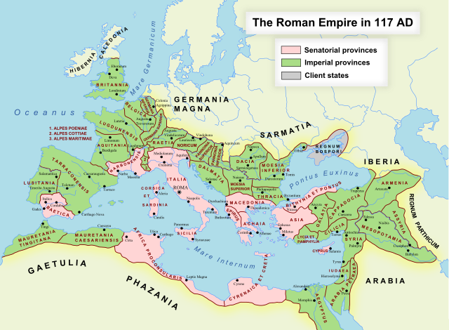
English: The maximum extent of the Roman Empire. Superimposed on a physical map. Senatorial Provinces Imperial Provinces Client States Español: Trabajo propio. Máxima extensión del Imperio Romano. Superpuesto en un mapa físico. Deutsch: Das Römische Reich zur Zeit seiner maximalen Ausehnung unter Trajan, 117 n. Chr. Senatorische Provinz Kaiserliche Provinz Klientelkönigtum |
||
| Date | (UTC) | ||
| Source |
This file was derived from: RomanEmpire 117.svg: |
||
| Author |
|
||
| Other versions | Derivative works of this file: RomanEmpire 117 recoloured 2.svg | ||
| SVG development |
|
Licensing
I, the copyright holder of this work, hereby publish it under the following license:
| I, the copyright holder of this work, release this work into the public domain. This applies worldwide. In some countries this may not be legally possible; if so: I grant anyone the right to use this work for any purpose, without any conditions, unless such conditions are required by law. |
Original upload log
This image is a derivative work of the following images:
- File:RomanEmpire_117.svg licensed with PD-self
- 2009-05-03T23:52:59Z Amadscientist 2180x1600 (2057461 Bytes) Returning map to last revision by [[User:Richardprins|Richardprins]] Gradient fill to dramatic and loses some titles and graphics.
- 2009-05-03T11:37:15Z Amadscientist 2180x1600 (2059503 Bytes) Gradient
- 2009-05-03T11:36:45Z Amadscientist 2180x1600 (2059503 Bytes) Gradient
- 2009-03-27T22:13:04Z Richardprins 2180x1600 (2057446 Bytes) Version with the latest revisions mostly from ArdadN and one from yug2
- 2008-09-06T13:38:51Z EliasAlucard 2180x1600 (635041 Bytes) '
- 2007-12-25T11:51:23Z File Upload Bot (Magnus Manske) 2180x1600 (567550 Bytes) {{BotMoveToCommons|en.wikipedia}} {{Information |Description={{en|Own work. The maximum extent of the Roman Empire. Superimposed on a physical map.}} |Source=Transfered from [http://en.wikipedia.org en.wikipedia] |Date=2007-
Uploaded with derivativeFX
File history
Click on a date/time to view the file as it appeared at that time.
| Date/Time | Thumbnail | Dimensions | User | Comment | |
|---|---|---|---|---|---|
| current | 23:09, 30 August 2018 | | 2,180 × 1,600 (1.11 MB) | Begoon | . |
| 22:51, 30 August 2018 |  | 2,180 × 1,600 (1.11 MB) | Begoon | fix validation errors | |
| 13:36, 9 December 2012 |  | 2,180 × 1,600 (1.96 MB) | Begoon | UTF8 | |
| 13:34, 9 December 2012 |  | 2,180 × 1,600 (1.96 MB) | Begoon | UTF8 - no BOM | |
| 13:25, 9 December 2012 |  | 2,180 × 1,600 (1.96 MB) | Begoon | nope - change size back | |
| 13:19, 9 December 2012 |  | 2,181 × 1,601 (1.44 MB) | Begoon | try to fix thumbnail rendering | |
| 13:03, 9 December 2012 |  | 2,180 × 1,600 (1.96 MB) | Begoon | == {{int:filedesc}} == {{Information |Description={{en|The maximum extent of the Roman Empire. Superimposed on a physical map. {{legend|#ffd5d5|Senatorial Provinces}} {{legend|#aade87|Imperial Provinces}} {{legend|#cccccc|Client States}}}} {{es|Trabajo... |
File usage
The following pages on the English Wikipedia use this file (pages on other projects are not listed):
Global file usage
The following other wikis use this file:
- Usage on fi.wikipedia.org