
File:River Roddlesworth - geograph.org.uk - 1322947.jpg
River_Roddlesworth_-_geograph.org.uk_-_1322947.jpg (640 × 424 pixels, file size: 161 KB, MIME type: image/jpeg)
| This is a file from the Wikimedia Commons. Information from its description page there is shown below. Commons is a freely licensed media file repository. You can help. |
Summary
| Description |
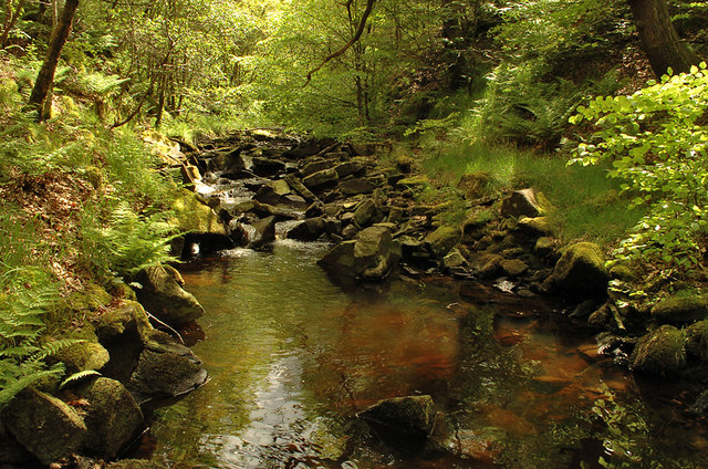
English: River Roddlesworth River Roddlesworth in Tockholes no.3 Plantation.
The source of the river is on the slopes of Great Hill, just above the ruins known as Pimm's, where the infant river is known as Calf Hey Brook. Calf Hey Brook is joined by another stream occasionally termed Roddlesworth - which rises beneath Cartridge Hill and runs past the ruins of Hollinshead Hall - beneath Slipper Lowe. From there, it follows a northerly course through Roddlesworth Plantations, around the two Roddlesworth Reservoirs fed by the river and past Red Lees (a name seemingly linked with that of the river). The river continues through the Stanworth Valley in Livesey, where it is met by Stockclough Brook, and under the M65 motorway and Leeds & Liverpool Canal. Soon after this, the Roddlesworth enters a culvert close to the Star Paper Mill. The Roddlesworth flows into the River Darwen at Moulden Brow. Between the confluence with Stockclough Brook and the Darwen, the river is known locally as Moulden (or Moulding) Water. |
| Date | |
| Source | From geograph.org.uk |
| Author | Gary Rogers |
| Attribution (required by the license) | Gary Rogers / River Roddlesworth / |
| Camera location | | View this and other nearby images on: OpenStreetMap |
|---|
_heading:157.00&language=en)
| Object location | | View this and other nearby images on: OpenStreetMap |
|---|
_heading:157.00&language=en)
Licensing

|
This image was taken from the Geograph project collection. See this photograph's page on the Geograph website for the photographer's contact details. The copyright on this image is owned by Gary Rogers and is licensed for reuse under the Creative Commons Attribution-ShareAlike 2.0 license.
|
- You are free:
- to share – to copy, distribute and transmit the work
- to remix – to adapt the work
- Under the following conditions:
- attribution – You must give appropriate credit, provide a link to the license, and indicate if changes were made. You may do so in any reasonable manner, but not in any way that suggests the licensor endorses you or your use.
- share alike – If you remix, transform, or build upon the material, you must distribute your contributions under the same or compatible license as the original.
File history
Click on a date/time to view the file as it appeared at that time.
| Date/Time | Thumbnail | Dimensions | User | Comment | |
|---|---|---|---|---|---|
| current | 22:24, 27 February 2011 | | 640 × 424 (161 KB) | GeographBot | == {{int:filedesc}} == {{Information |description={{en|1=River Roddlesworth River Roddlesworth in Tockholes no.3 Plantation. The source of the river is on the slopes of Great Hill, just above the ruins known as Pimm's, where the infant river is known a |