File:Relative height of Great Shunner Fell.png

Page contents not supported in other languages.
This is a file from the Wikimedia Commons
From Wikipedia, the free encyclopedia

Original file(1,196 × 1,987 pixels, file size: 3.6 MB, MIME type: image/png)

Summary

Description
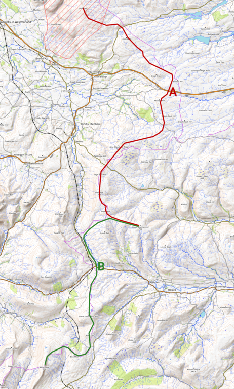
English: Determining the relative height of Great Shunner Fell (716 m), showing the two highest possible paths to Whernside (736 m) resp. Little Fell (745 m). While Whernside is nearer, the path has to descend to Garsdale Head at 324 m (B), whereas the path to Little Fell is nowhere lower than 419 m (A).
Deutsch: Bestimmung der Schartenhöhe des Great Shunner Fell (716 m). Gezeigt sind die zwei höchstmöglichen Wege zu höheren Bergen, dem Whernside (736 m) im Süden und dem Little Fell (745 m) im Norden. Whernside liegt zwar näher, der Weg muss aber bis Garsdale Head (324 m, Punkt B) absteigen, während der Weg nach Little Fell nur bis auf 419 m (A) absteigen muss.
Date
Source Map data: OpenStreetMap contributors; map rendering: OpenTopoMap.org, edited by Own work
Author Kreuzschnabel
Permission
(Reusing this file)
Image by Kreuzschnabel/Wikimedia Commons, License: artlibre

Licensing: Choose any of the following licenses for reuse of this work. Usage is free of charge as long as all terms of the license chosen are complied with. If you would like alternative terms, please get in touch with me via Wikimail or leave a request on my my discussion page to negotiate.

  • Using online: A typical example of reusing my images is given at the right, showing the author’s name and a link to the license used.
  • Using in printed media: Either close to the image or in a separate image directory, as long as unambiguously assigned, the author and license used should be specified, like: Photo: Kreuzschnabel/Wikimedia Commons, Licence: Cc-by-sa-3.0 (https://creativecommons.org/licenses/by-sa/3.0/legalcode)

In any case, I should be glad to receive a Wikimail message or, for printed media, a sample copy.

→ More information about reuse outside Wikimedia projects.

This file is copyrighted and has been released under licenses which are incompatible with Facebook's licensing terms. Therefore, it is not permitted to upload this file to Facebook. This applies accordingly to a large number of other social networks or other interactive sites.

I, the copyright holder of this work, hereby publish it under the following license:
w:en:Creative Commons
attribution share alike
This file is licensed under the Creative Commons Attribution-Share Alike 3.0 Unported license.
You are free:
  • to share – to copy, distribute and transmit the work
  • to remix – to adapt the work
Under the following conditions:
  • attribution – You must give appropriate credit, provide a link to the license, and indicate if changes were made. You may do so in any reasonable manner, but not in any way that suggests the licensor endorses you or your use.
  • share alike – If you remix, transform, or build upon the material, you must distribute your contributions under the same or compatible license as the original.
GNU head Permission is granted to copy, distribute and/or modify this document under the terms of the GNU Free Documentation License, Version 1.2 or any later version published by the Free Software Foundation; with no Invariant Sections, no Front-Cover Texts, and no Back-Cover Texts. A copy of the license is included in the section entitled GNU Free Documentation License.
Licence Art Libre Copyleft: This work of art is free; you can redistribute it and/or modify it according to terms of the Free Art License. You will find a specimen of this license on the Copyleft Attitude site as well as on other sites.
Description
This map was created from OpenStreetMap project data, collected by the community. This map may be incomplete, and may contain errors. Don't rely solely on it for navigation.
Date (see file history)
Source openstreetmap.org
Creator
OpenStreetMap contributors
Permission
(Reusing this file)

OpenStreetMap data is available under the Open Database License (details). Map tiles are licensed under the Creative Commons Attribution-ShareAlike 2.0 license (CC-BY-SA 2.0).

This work contains information from OpenStreetMap, which is made available under the Open Database License (ODbL).

The ODbL does not require any particular license for maps produced from ODbL data. Prior to 1 August 2020, map tiles produced by the OpenStreetMap Foundation were licensed under the CC-BY-SA-2.0 license. Maps produced by other people may be subject to other licences.

w:en:Creative Commons
attribution share alike
This file is licensed under the Creative Commons Attribution-Share Alike 2.0 Generic license.
You are free:
  • to share – to copy, distribute and transmit the work
  • to remix – to adapt the work
Under the following conditions:
  • attribution – You must give appropriate credit, provide a link to the license, and indicate if changes were made. You may do so in any reasonable manner, but not in any way that suggests the licensor endorses you or your use.
  • share alike – If you remix, transform, or build upon the material, you must distribute your contributions under the same or compatible license as the original.
Georeferencing Georeference the map in Wikimaps Warper If inappropriate please set warp_status = skip to hide.

Captions

Add a one-line explanation of what this file represents

Items portrayed in this file

depicts

7 October 2019

File history

Click on a date/time to view the file as it appeared at that time.

Date/TimeThumbnailDimensionsUserComment
current09:46, 7 October 2019Thumbnail for version as of 09:46, 7 October 20191,196 × 1,987 (3.6 MB)Kreuzschnabel{{Information |description ={{en|1=Determining the relative height of Great Shunner Fell (716 m), showing the two highest possible paths to Whernside (736 m) resp. Little Fell (745 m). While Whernside is nearer, the path has to descend to Garsdale Head at 324 m (B), whereas the path to Little Fell is nowhere lower than 419 m (A). }} {{de|1=Bestimmung der Schartenhöhe des Great Shunner Fell (716 m). Gezeigt sind die zwei höchstmöglichen Wege zu höheren Bergen, dem Whernside (736 m) im Süden...
The following pages on the English Wikipedia use this file (pages on other projects are not listed):

Global file usage

The following other wikis use this file:

Metadata