
File:Pocahontas Coalfield.svg

Size of this PNG preview of this SVG file: 430 × 300 pixels. Other resolutions: 320 × 223 pixels | 640 × 447 pixels | 1,024 × 714 pixels | 1,280 × 893 pixels | 2,560 × 1,786 pixels.
Original file (SVG file, nominally 430 × 300 pixels, file size: 111 KB)
| This is a file from the Wikimedia Commons. Information from its description page there is shown below. Commons is a freely licensed media file repository. You can help. |
Summary
| Description |
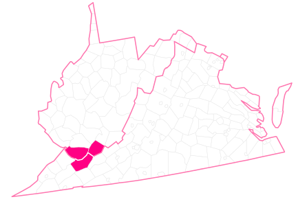
English: Map of the Pocahontas Coalfield which covers McDowell County West Virginia, Mercer County West Virginia, && Tazewell County Virginia |
| Date | |
| Source | Own work |
| Author | Kelvinsong |
Licensing
I, the copyright holder of this work, hereby publish it under the following license:
| This file is made available under the Creative Commons CC0 1.0 Universal Public Domain Dedication. | |
| The person who associated a work with this deed has dedicated the work to the public domain by waiving all of their rights to the work worldwide under copyright law, including all related and neighboring rights, to the extent allowed by law. You can copy, modify, distribute and perform the work, even for commercial purposes, all without asking permission.
|
File history
Click on a date/time to view the file as it appeared at that time.
| Date/Time | Thumbnail | Dimensions | User | Comment | |
|---|---|---|---|---|---|
| current | 23:37, 12 March 2014 | | 430 × 300 (111 KB) | IsadoraofIbiza | transparency |
| 23:35, 12 March 2014 |  | 430 × 300 (110 KB) | IsadoraofIbiza | User created page with UploadWizard |
File usage
The following pages on the English Wikipedia use this file (pages on other projects are not listed):