
File:Perry County Civil War Era Map.png

Size of this preview: 615 × 599 pixels. Other resolutions: 246 × 240 pixels | 493 × 480 pixels | 735 × 716 pixels.
Original file (735 × 716 pixels, file size: 1.37 MB, MIME type: image/png)
| This is a file from the Wikimedia Commons. Information from its description page there is shown below. Commons is a freely licensed media file repository. You can help. |
Summary
| Description |
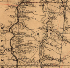
English: Excerpt of an 1874 re-printing of a Union military map of Tennessee, depicting Perry County during the early 1860s |
| Date | |
| Source | https://www.loc.gov/resource/g3960.cw0393000 |
| Author | C. S. Mergell |
Licensing
|
This work is in the public domain in its country of origin and other countries and areas where the copyright term is the author's life plus 70 years or fewer. This work is in the public domain in the United States because it was published (or registered with the U.S. Copyright Office) before January 1, 1929. | |
| This file has been identified as being free of known restrictions under copyright law, including all related and neighboring rights. | |
File history
Click on a date/time to view the file as it appeared at that time.
| Date/Time | Thumbnail | Dimensions | User | Comment | |
|---|---|---|---|---|---|
| current | 15:46, 6 December 2022 | | 735 × 716 (1.37 MB) | Nfutvol | Uploaded a work by C. S. Mergell from https://www.loc.gov/resource/g3960.cw0393000 with UploadWizard |
File usage
The following pages on the English Wikipedia use this file (pages on other projects are not listed):