
File:PA-Delaware-wedge.png
Size of this preview: 394 × 599 pixels. Other resolutions: 158 × 240 pixels | 316 × 480 pixels | 659 × 1,002 pixels.
Original file (659 × 1,002 pixels, file size: 470 KB, MIME type: image/png)
| This is a file from the Wikimedia Commons. Information from its description page there is shown below. Commons is a freely licensed media file repository. You can help. |
Summary
| Description |
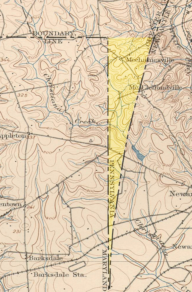
English: An 1898 United States Geological Survey view of the Elkton, Maryland quadrangle, showing the "wedge" area between Delaware and Maryland. This wedge of land, resulting from surveying oddities in colonial times, was the space left between the North Line--Maryland's eastern border--and the Twelve-Mile Circle--Delaware's western border. The land now belongs to Delaware, but, in this 1898 map, was considered a part of Pennsylvania. (The yellow highlight is an addition to the original map.) |
| Source | United States Geological Survey |
| Author |
Licensing
This work is in the public domain in the United States because it is a work prepared by an officer or employee of the United States Government as part of that person’s official duties under the terms of Title 17, Chapter 1, Section 105 of the US Code.
Note: This only applies to original works of the Federal Government and not to the work of any individual U.S. state, territory, commonwealth, county, municipality, or any other subdivision. This template also does not apply to postage stamp designs published by the United States Postal Service since 1978. (See § 313.6(C)(1) of Compendium of U.S. Copyright Office Practices). It also does not apply to certain US coins; see The US Mint Terms of Use.
|
 | |
| This file has been identified as being free of known restrictions under copyright law, including all related and neighboring rights. | ||
File history
Click on a date/time to view the file as it appeared at that time.
| Date/Time | Thumbnail | Dimensions | User | Comment | |
|---|---|---|---|---|---|
| current | 02:18, 29 April 2008 | | 659 × 1,002 (470 KB) | Captadam | {{Information |Description=An 1898 United States Geological Survey view of the Elkton, Maryland quadrangle, showing the "wedge" area between Delaware and Maryland. This wedge of land, resulting from surveying oddities in colonial times, was the space left |
File usage
The following pages on the English Wikipedia use this file (pages on other projects are not listed):
Global file usage
The following other wikis use this file:
- Usage on ja.wikipedia.org