
File:Map of Poland and Lithuania (1618-1667).svg

Size of this PNG preview of this SVG file: 750 × 599 pixels. Other resolutions: 300 × 240 pixels | 601 × 480 pixels | 961 × 768 pixels | 1,280 × 1,023 pixels | 2,560 × 2,046 pixels | 1,205 × 963 pixels.
Original file (SVG file, nominally 1,205 × 963 pixels, file size: 116 KB)
| This is a file from the Wikimedia Commons. Information from its description page there is shown below. Commons is a freely licensed media file repository. You can help. |
.svg)
| Description |
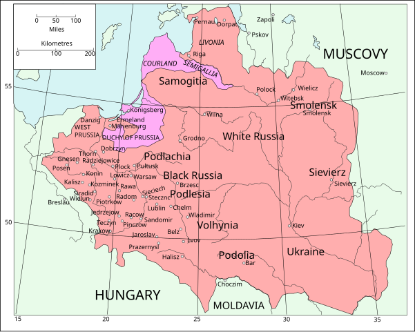
English: Map of Poland and Lithuania following the Union of Lublin in 1569.
|
||
| Date | (UTC) | ||
| Source | Map of Poland and Lithuania after the Union of Lublin (1569).jpg | ||
| Author |
|
||
| SVG development |
|
.jpg)
This file is licensed under the Creative Commons Attribution-Share Alike 3.0 Unported license.
- You are free:
- to share – to copy, distribute and transmit the work
- to remix – to adapt the work
- Under the following conditions:
- attribution – You must give appropriate credit, provide a link to the license, and indicate if changes were made. You may do so in any reasonable manner, but not in any way that suggests the licensor endorses you or your use.
- share alike – If you remix, transform, or build upon the material, you must distribute your contributions under the same or compatible license as the original.
| File | Type | Details |
|---|---|---|
| File:Polish-Lithuania map (1450-1600).svg | Large SVG | Map showing conflicts and territorial changes on the Polish-Lithuanian—Russian border, 1450–1600 |
| File:Duchy of Prussia.svg | Small SVG | Map of the Duchy of Prussia |
| File:Livonian war map (1558-1560).svg | Small SVG | Map showing campaigns in Livonia, 1558–1560. |
| File:Map of Poland and Lithuania after the Union of Lublin (1569).svg | Large SVG | Map of the w:Polish-Lithuanian Commonwealth after the Union of Lublin in 1569. |
| File:Livonian war map (1570-1577).svg | Small SVG | Map showing areas of Russian and Polish-Lithuanian forces, 1570–1577. |
| File:Campaigns of Stefan Batory.svg | Small SVG | Map of the campaign of Stefan Batory in Livonia (1575–1580). |
| File:Map of Poland and Lithuania in 1600.svg | Small SVG | Map of Livonia in 1600 |
| See also: User:Halibutt/maps, by Halibutt (talk · contribs). | ||
.svg)
.svg)
.svg)
.svg)
Original upload log
This image is a derivative work of the following images:
- Map of Poland and Lithuania after the Union of Lublin (1569).jpg licensed with PD-1923, PD-UK-unknown
- 2011-04-12T13:13:53Z Grandiose 1660x1027 (1008090 Bytes) Improve colouring.
- 2011-04-12T12:58:38Z Grandiose 1660x1027 (402170 Bytes) {{Information |Description ={{en|1=Map of Poland and Lithuania following the Union of Lublin in 1569. Taken from "The Cambridge Modern History Atlas", 1912, London: Cambridge University Press. Editors were Sir Adolphus W
File history
Click on a date/time to view the file as it appeared at that time.
| Date/Time | Thumbnail | Dimensions | User | Comment | |
|---|---|---|---|---|---|
| current | 16:44, 9 May 2011 | | 1,205 × 963 (116 KB) | Grandiose | Done my best on the Swedish coastline |
| 10:29, 14 April 2011 |  | 1,205 × 963 (116 KB) | Grandiose | A couple more places, Duchy statuses. | |
| 17:05, 13 April 2011 |  | 1,205 × 963 (117 KB) | Grandiose | {{Information |Description={{en|1=Map of Poland and Lithuania following the Union of Lublin in 1569. Adapted from "The Cambridge Modern History Atlas", 1912, London: Cambridge University Press. (See source file for more information.)}} |Source=*[[:File:M |
File usage
No pages on the English Wikipedia use this file (pages on other projects are not listed).
Global file usage
The following other wikis use this file:
- Usage on ca.wikipedia.org
- Usage on de.wikipedia.org
- Usage on fr.wikipedia.org
- Usage on uk.wikipedia.org
.svg)