
File:Map galilee cruises 123.jpg
No higher resolution available.
Map_galilee_cruises_123.jpg (678 × 483 pixels, file size: 138 KB, MIME type: image/jpeg)
| This is a file from the Wikimedia Commons. Information from its description page there is shown below. Commons is a freely licensed media file repository. You can help. |
| Description |
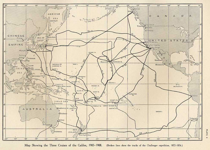
English: Map showing the three cruises undertaken by the Galilee while under charter to the Department of Terrestrial Magnetism. The track of the Challenger expedition 1872-1876 is also shown as a dashed line |
||||||
| Date | |||||||
| Source | Taken from Plate 6 Ocean Magnetic Observations, 1905-1916, and Reports on Special Researches. By L. A. Bauer, with W. J. Peters, J. A. Fleming, J. P. Ault, and W. F. G. Swann. Carnegie Institution of Washington Publication 175, vol. 3, pages 6-7, reprinted here | ||||||
| Author | Carnegie Institution of Washington's Department of Terrestrial Magnetism | ||||||
| Permission (Reusing this file) |
|


File history
Click on a date/time to view the file as it appeared at that time.
| Date/Time | Thumbnail | Dimensions | User | Comment | |
|---|---|---|---|---|---|
| current | 23:58, 22 February 2011 | | 678 × 483 (138 KB) | Mikenorton | {{Information |Description ={{en|1=Map showing the three cruises undertaken by the ''Galilee'' while under charter to the Department of Terrestrial Magnetism. The track of the Challenger expedition 1872-1876 is also shown as a dashed line}} |Source |
File usage
The following pages on the English Wikipedia use this file (pages on other projects are not listed):