
File:Lyon rings of fortification map-blank.svg

Size of this PNG preview of this SVG file: 600 × 600 pixels. Other resolutions: 240 × 240 pixels | 480 × 480 pixels | 768 × 768 pixels | 1,024 × 1,024 pixels | 2,048 × 2,048 pixels | 1,750 × 1,750 pixels.
Original file (SVG file, nominally 1,750 × 1,750 pixels, file size: 462 KB)
| This is a file from the Wikimedia Commons. Information from its description page there is shown below. Commons is a freely licensed media file repository. You can help. |
Summary
| Description |
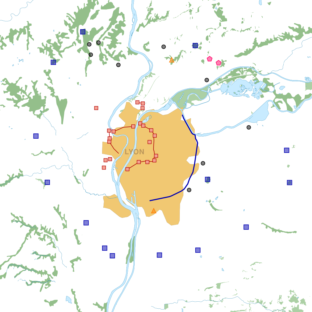
English: Map of the first ring of fortifications of Lyon (France), the Rohault de Fleury defensive system (1831-1854). Legend: Fort
Artillery battery
Redoubt
Warehouse Français : Carte des deux ceintures de fortifications de Lyon (France), le système de défense Rohault de Fleury et celui de Séré de Rivières. Légende : Fort
Batterie
Redoute
Magasin |
| Date | (UTC) |
| Source |
This file was derived from: |
| Author |
|
| Other versions | |
| SVG | W3C-validity not checked. |
| Atelier graphique |
Licensing
This file is licensed under the Creative Commons Attribution-Share Alike 2.0 Generic license.
- You are free:
- to share – to copy, distribute and transmit the work
- to remix – to adapt the work
- Under the following conditions:
- attribution – You must give appropriate credit, provide a link to the license, and indicate if changes were made. You may do so in any reasonable manner, but not in any way that suggests the licensor endorses you or your use.
- share alike – If you remix, transform, or build upon the material, you must distribute your contributions under the same or compatible license as the original.
Original upload log
This image is a derivative work of the following images:
- File:Lyon_Rohault_de_Fleury_fortifications_map-blank.svg licensed with Cc-by-sa-2.0
- 2011-05-20T12:22:23Z Sémhur 800x800 (588740 Bytes) 2 - Few mistakes corrected
- 2011-05-19T18:17:24Z Sémhur 800x800 (587132 Bytes) =={{int:filedesc}}== {{Information |Description={{Multilingual description |en= Map of the first ring of [[:en:fortifications of Lyon|]] (France), the Rohault de Fleury defensive system (1831-1854). Legend: |fr= Carte de la p
- File:Lyon_Séré_de_Rivières_fortifications_map-blank.svg licensed with Cc-by-sa-2.0
- 2012-03-08T15:41:32Z Sémhur 1750x1750 (620670 Bytes) Correcting Fort du Mont Verdun's location; new colour for redoubts
- 2012-03-08T13:38:41Z Sémhur 1750x1750 (620610 Bytes) =={{int:filedesc}}== {{Information |Description={{Multilingual description |en= Map of the first ring of [[:en:fortifications of Lyon|fortifications of Lyon]] (France), the Rohault de Fleury defensive system (1831-1854). Leg
Uploaded with derivativeFX
File history
Click on a date/time to view the file as it appeared at that time.
| Date/Time | Thumbnail | Dimensions | User | Comment | |
|---|---|---|---|---|---|
| current | 13:30, 20 July 2012 | | 1,750 × 1,750 (462 KB) | Sémhur | 26 = magasin à poudre 27 = batterie |
| 11:19, 19 July 2012 |  | 1,750 × 1,750 (462 KB) | Sémhur | + Magasin de Saint-Fons & Batterie de Décines | |
| 13:15, 24 March 2012 |  | 1,750 × 1,750 (462 KB) | Otourly | == {{int:filedesc}} == {{Information |Description={{Multilingual description |en= Map of the first ring of fortifications of Lyon (France), the Rohault de Fleury defensive system (1831-1854). <br>Legend: {{Legend||Fort|fi... |
File usage
The following pages on the English Wikipedia use this file (pages on other projects are not listed):
Global file usage
The following other wikis use this file:
- Usage on fr.wikipedia.org
- Usage on he.wikipedia.org