
File:Hazarajat-map.png
No higher resolution available.
Hazarajat-map.png (300 × 238 pixels, file size: 208 KB, MIME type: image/png)
Summary[edit]
| Description |
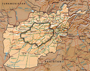
Hazarajat region shown within Afghanistan |
|---|---|
| Source | |
| Article | |
| Portion used | |
| Low resolution? |
Yes |
| Purpose of use |
For fair use in the article Hazarajat |
| Replaceable? |
There is no free equivalent of this image |
| Fair useFair use of copyrighted material in the context of Hazarajat//en.wikipedia.org/wiki/File:Hazarajat-map.pngtrue | |
Licensing[edit]
This article may contain improper use of non-free material. |
File history
Click on a date/time to view the file as it appeared at that time.
| Date/Time | Thumbnail | Dimensions | User | Comment | |
|---|---|---|---|---|---|
| current | 02:22, 1 October 2018 | | 300 × 238 (208 KB) | Shxahxh (talk | contribs) | {{Non-free use rationale | Description = Hazarajat | Source = [https://colonyofcommodus.wordpress.com/category/international-affairs/page/2/] | Article = Hazarajat | Portion = | Low resolution = Yes | Purpose = For fair use in the article Hazarajat | Replaceability = There is no free equivalent of this image | Other information = }} ==Licensing== {{Non-free}} |
You cannot overwrite this file.
File usage
The following pages on the English Wikipedia use this file (pages on other projects are not listed):