File:DNL international route map.svg

Page contents not supported in other languages.
This is a file from the Wikimedia Commons
From Wikipedia, the free encyclopedia

Original file(SVG file, nominally 454 × 450 pixels, file size: 325 KB)

Description
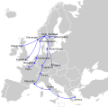
English: Route map of Det Norske Luftfartselskap's international services in 1947. Source: [1]
Date (UTC)
Source
Author
I, the copyright holder of this work, hereby publish it under the following license:
w:en:Creative Commons
attribution share alike
This file is licensed under the Creative Commons Attribution-Share Alike 2.5 Generic license.
You are free:
  • to share – to copy, distribute and transmit the work
  • to remix – to adapt the work
Under the following conditions:
  • attribution – You must give appropriate credit, provide a link to the license, and indicate if changes were made. You may do so in any reasonable manner, but not in any way that suggests the licensor endorses you or your use.
  • share alike – If you remix, transform, or build upon the material, you must distribute your contributions under the same or compatible license as the original.

Original upload log

This image is a derivative work of the following images:

  • File:Blank_map_of_Europe_EU27_iso3166-1_code.svg licensed with Cc-by-sa-2.5
    • 2009-03-14T10:55:56Z Amibreton 454x450 (490785 Bytes) {{Information |Description={{en|1=Blank Map of Europe in SVG format oriented towards EU-27 (European Union of 27 member states) mapping. Each country has an id which is its ISO-3116-1-ALPHA2 code in lower case for easy colour

Uploaded with derivativeFX

Captions

Add a one-line explanation of what this file represents

Items portrayed in this file

depicts

2 March 2010

image/svg+xml

e2d17a2bc5dad2b347435e98f93cd1e19d170077

333,250 byte

450 pixel

454 pixel

File history

Click on a date/time to view the file as it appeared at that time.

Date/TimeThumbnailDimensionsUserComment
current17:26, 25 December 2022Thumbnail for version as of 17:26, 25 December 2022454 × 450 (325 KB)IktsokhExtended Soviet borders
01:50, 19 November 2022Thumbnail for version as of 01:50, 19 November 2022454 × 450 (365 KB)M.BittonReverted to version as of 13:49, 2 March 2010 (UTC): I suggest you read COM:OVERWRITE
18:36, 18 November 2022Thumbnail for version as of 18:36, 18 November 2022454 × 450 (322 KB)Рагин1987Extended map
13:49, 2 March 2010Thumbnail for version as of 13:49, 2 March 2010454 × 450 (365 KB)Arsenikk{{Information |Description={{en|1=Route map of Det Norske Luftfartselskap's international services in 1947. Source: [http://www.timetableimages.com/i-mn/no4710i.jpg] |Source=*File:Blank_map_of_Europe_EU27_iso3166-1_code.svg |Date=2010-03-02 13:47 (U
The following pages on the English Wikipedia use this file (pages on other projects are not listed):

Metadata